Granite City Topo Map Illinois
To zoom in, hover over the map of Granite City
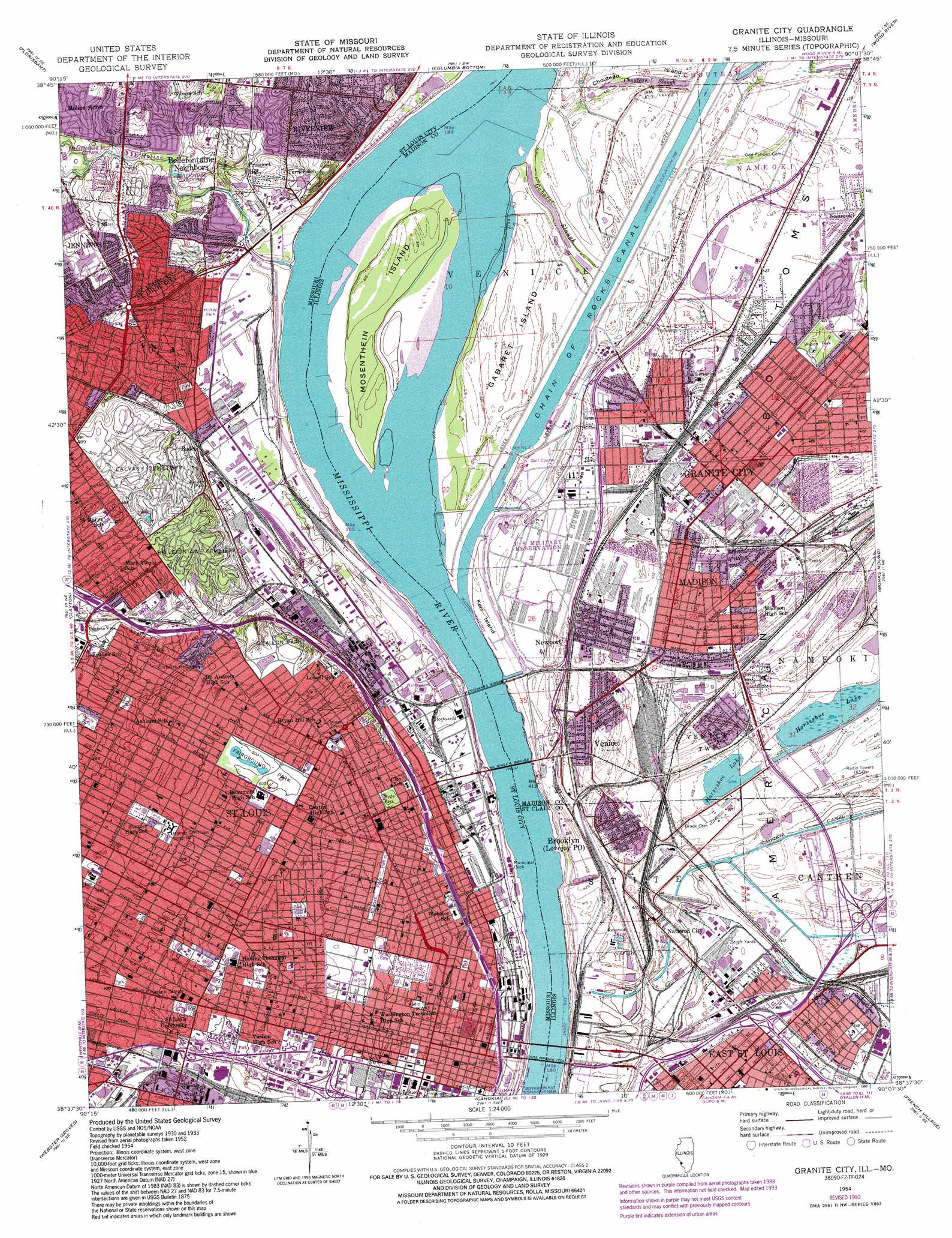
USGS Topo Quad 38090f2 - 1:24,000 scale
| Topo Map Name: | Granite City |
| USGS Topo Quad ID: | 38090f2 |
| Print Size: | ca. 21 1/4" wide x 27" high |
| Southeast Coordinates: | 38.625° N latitude / 90.125° W longitude |
| Map Center Coordinates: | 38.6875° N latitude / 90.1875° W longitude |
| U.S. States: | IL, MO |
| Filename: | o38090f2.jpg |
| Download Map JPG Image: | Granite City topo map 1:24,000 scale |
| Map Type: | Topographic |
| Topo Series: | 7.5´ |
| Map Scale: | 1:24,000 |
| Source of Map Images: | United States Geological Survey (USGS) |
| Alternate Map Versions: |
Granite City IL 1933 Download PDF Buy paper map Granite City IL 1935 Download PDF Buy paper map Granite City IL 1940 Download PDF Buy paper map Granite City IL 1940, updated 1950 Download PDF Buy paper map Granite City IL 1940, updated 1950 Download PDF Buy paper map Granite City IL 1954, updated 1958 Download PDF Buy paper map Granite City IL 1954, updated 1966 Download PDF Buy paper map Granite City IL 1954, updated 1969 Download PDF Buy paper map Granite City IL 1954, updated 1975 Download PDF Buy paper map Granite City IL 1954, updated 1982 Download PDF Buy paper map Granite City IL 1954, updated 1993 Download PDF Buy paper map Granite City IL 1993, updated 1996 Download PDF Buy paper map Granite City IL 1998, updated 1999 Download PDF Buy paper map Granite City IL 2012 Download PDF Buy paper map Granite City IL 2015 Download PDF Buy paper map |
1:24,000 Topo Quads surrounding Granite City
Grafton |
Elsah |
Alton |
Bethalto |
Prairietown |
Saint Charles |
Florissant |
Columbia Bottom |
Wood River |
Edwardsville |
Creve Coeur |
Clayton |
Granite City |
Monks Mound |
Collinsville |
Kirkwood |
Webster Groves |
Cahokia |
French Village |
O'Fallon |
Maxville |
Oakville |
Columbia |
Millstadt |
Freeburg |
> Back to 38090e1 at 1:100,000 scale
> Back to 38090a1 at 1:250,000 scale
> Back to U.S. Topo Maps home
Granite City topo map: Gazetteer
Granite City: Airports
Fostaire Heliport elevation 123m 403′Saint Louis Area Support Center Heliport elevation 126m 413′
Saint Louis Downtown Heliport elevation 121m 396′
Veterans Administration Medical Center Heliport elevation 163m 534′
Granite City: Bridges
Eads Bridge elevation 121m 396′Martin Luther King Junior Memorial Bridge elevation 121m 396′
McKinley Bridge elevation 122m 400′
McKinley Bridge elevation 122m 400′
Merchants Bridge elevation 122m 400′
Merchants Bridge elevation 122m 400′
Granite City: Canals
Granite City Sewer Canal elevation 133m 436′Granite City: Channels
Gabaret Slough elevation 123m 403′Mosenthein Chute elevation 120m 393′
Mosenthein Chute elevation 120m 393′
Granite City: Crossings
Interchange 2 elevation 128m 419′Interchange 244B elevation 150m 492′
Interchange 245A elevation 148m 485′
Interchange 245B elevation 138m 452′
Interchange 246A elevation 142m 465′
Interchange 246B elevation 142m 465′
Interchange 247 elevation 139m 456′
Interchange 248B elevation 137m 449′
Interchange 248C elevation 135m 442′
Interchange 249A elevation 143m 469′
Interchange 249B elevation 144m 472′
Interchange 249C elevation 144m 472′
Interchange 249D elevation 144m 472′
Interchange 250A elevation 143m 469′
Interchange 250B elevation 140m 459′
Interchange 250C elevation 143m 469′
Interchange 2A elevation 125m 410′
Interchange 3 elevation 127m 416′
Interchange 36D elevation 140m 459′
Interchange 37A elevation 142m 465′
Interchange 38A elevation 147m 482′
Interchange 38C elevation 152m 498′
Interchange 38D elevation 139m 456′
Interchange 4 elevation 124m 406′
Granite City: Dams
Lock Number 27 elevation 125m 410′Granite City: Flats
Kerr Island elevation 125m 410′Granite City: Harbors
Bi-State Development Agency Harbor elevation 132m 433′Granite City: Islands
Gabaret Island elevation 125m 410′Mosenthein Island elevation 126m 413′
Granite City: Levees
Chouteau Nameoki and Venice Levee elevation 127m 416′Eastside Levee and Sanitary District Levee elevation 130m 426′
Granite City: Parks
Busche Park elevation 142m 465′Christ Church Cathedral elevation 143m 469′
Columbus Square Park elevation 141m 462′
DeSoto Park elevation 152m 498′
Edward Jones Dome elevation 141m 462′
Fairground Park elevation 153m 501′
Hickey Park elevation 130m 426′
Hyde Park elevation 148m 485′
Lee Park elevation 125m 410′
Lucas Gardens elevation 145m 475′
Murphy Park elevation 156m 511′
O'Fallon Park elevation 158m 518′
Penrose Park elevation 150m 492′
Pickett Playground elevation 156m 511′
Rumbold Park elevation 153m 501′
Saint Louis Park elevation 153m 501′
Soldiers Memorial elevation 150m 492′
Tandy Park elevation 157m 515′
Washington Park elevation 141m 462′
Wilson Park elevation 128m 419′
Granite City: Populated Places
Baden elevation 131m 429′Bellefontaine Neighbors elevation 140m 459′
Brooklyn elevation 126m 413′
Carr Square elevation 152m 498′
College Hill elevation 146m 479′
Columbus Square elevation 136m 446′
Covenant Blu-Grand Center elevation 129m 423′
Eagle Park elevation 125m 410′
Granite City elevation 129m 423′
Greater Ville elevation 158m 518′
Hyde Park elevation 145m 475′
Jeff Vander Lou elevation 144m 472′
Lacledes Landing elevation 150m 492′
Madison elevation 126m 413′
Madison Station elevation 126m 413′
Mark Twain elevation 153m 501′
Midtown elevation 153m 501′
Moline Acres elevation 146m 479′
Nameoki elevation 128m 419′
National City elevation 125m 410′
Near North Riverfront elevation 161m 528′
Newport elevation 126m 413′
North Pointe elevation 151m 495′
North Riverfront elevation 129m 423′
North Venice elevation 126m 413′
O'Fallon elevation 153m 501′
Old North Saint Louis elevation 155m 508′
Penrose elevation 146m 479′
Prospect Hill elevation 141m 462′
Riverview elevation 167m 547′
Saint Louis elevation 142m 465′
Saint Louis Place elevation 139m 456′
The Ville elevation 152m 498′
Vandeventer elevation 167m 547′
Venice elevation 125m 410′
Walnut Park East elevation 153m 501′
Granite City: Post Offices
Baden Post Office elevation 131m 429′Fairground Post Office elevation 150m 492′
Granite City Post Office elevation 128m 419′
Henry W Wheeler Post Office elevation 144m 472′
Jefferson Memorial Post Office elevation 144m 472′
Madison Post Office elevation 126m 413′
Marian Oldham Post Office elevation 143m 469′
Venice Post Office elevation 125m 410′
Granite City: Streams
Maline Creek elevation 129m 423′Schoenberger Creek elevation 125m 410′
Granite City: Summits
Big Mound (historical) elevation 144m 472′Granite City digital topo map on disk
Buy this Granite City topo map showing relief, roads, GPS coordinates and other geographical features, as a high-resolution digital map file on DVD: