Jersey Island Topo Map California
To zoom in, hover over the map of Jersey Island
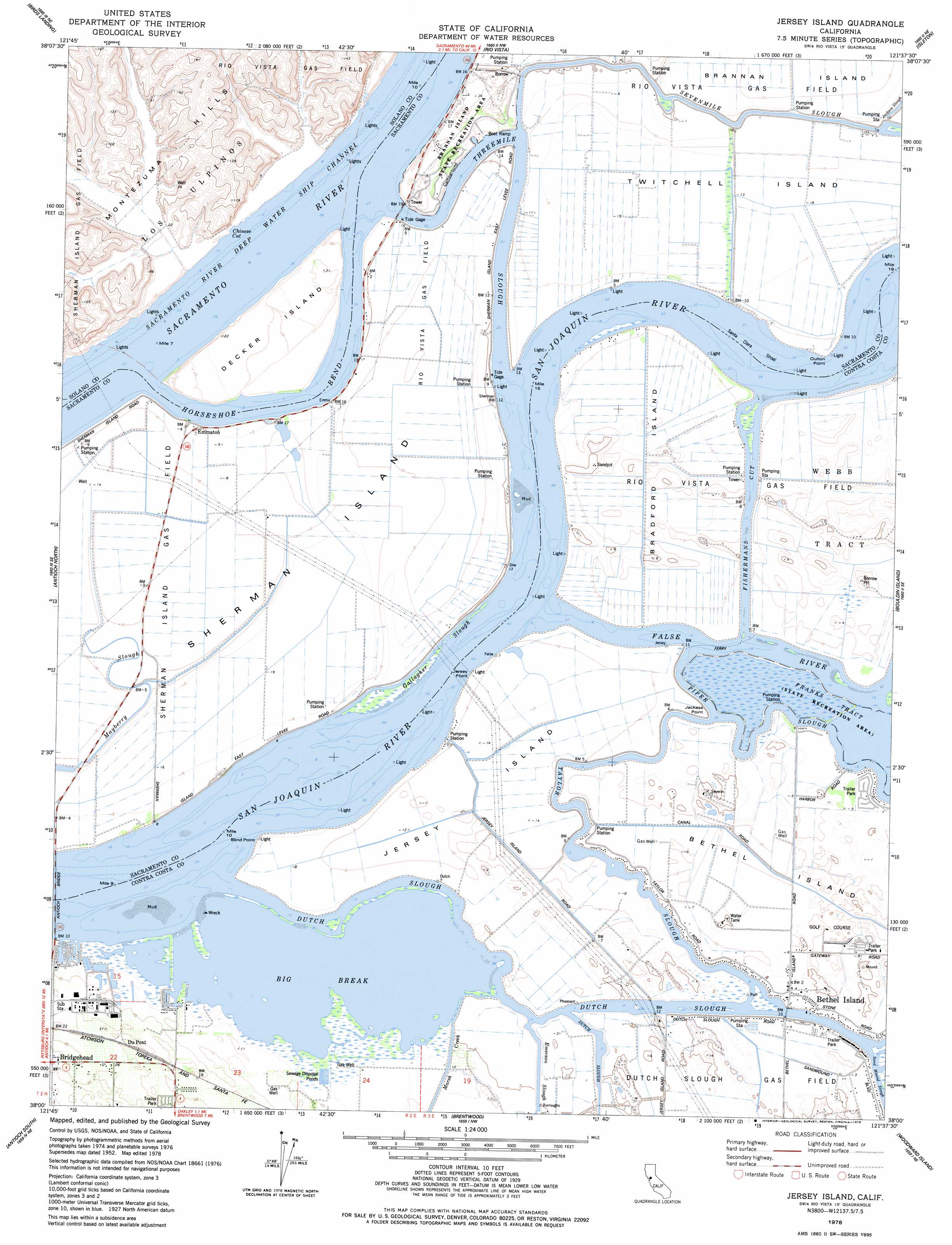
USGS Topo Quad 38121a6 - 1:24,000 scale
| Topo Map Name: | Jersey Island |
| USGS Topo Quad ID: | 38121a6 |
| Print Size: | ca. 21 1/4" wide x 27" high |
| Southeast Coordinates: | 38° N latitude / 121.625° W longitude |
| Map Center Coordinates: | 38.0625° N latitude / 121.6875° W longitude |
| U.S. State: | CA |
| Filename: | o38121a6.jpg |
| Download Map JPG Image: | Jersey Island topo map 1:24,000 scale |
| Map Type: | Topographic |
| Topo Series: | 7.5´ |
| Map Scale: | 1:24,000 |
| Source of Map Images: | United States Geological Survey (USGS) |
| Alternate Map Versions: |
Jersey Island CA 1952, updated 1954 Download PDF Buy paper map Jersey Island CA 1952, updated 1962 Download PDF Buy paper map Jersey Island CA 1952, updated 1969 Download PDF Buy paper map Jersey Island CA 1978, updated 1978 Download PDF Buy paper map Jersey Island CA 2012 Download PDF Buy paper map Jersey Island CA 2015 Download PDF Buy paper map |
1:24,000 Topo Quads surrounding Jersey Island
Elmira |
Dozier |
Liberty Island |
Courtland |
Bruceville |
Denverton |
Birds Landing |
Rio Vista |
Isleton |
Thornton |
Honker Bay |
Antioch North |
Jersey Island |
Bouldin Island |
Terminous |
Clayton |
Antioch South |
Brentwood |
Woodward Island |
Holt |
Diablo |
Tassajara |
Byron Hot Springs |
Clifton Court Forebay |
Union Island |
> Back to 38121a1 at 1:100,000 scale
> Back to 38120a1 at 1:250,000 scale
> Back to U.S. Topo Maps home
Jersey Island topo map: Gazetteer
Jersey Island: Bars
Santa Clara Shoal elevation 0m 0′Jersey Island: Bays
Big Break elevation 0m 0′Chinese Cut elevation 0m 0′
Jersey Island: Bends
Horseshoe Bend elevation 0m 0′Jersey Island: Bridges
Threemile Bridge elevation -2m -7′Jersey Island: Canals
Fishermans Cut elevation 0m 0′Jersey Island: Capes
Blind Point elevation 0m 0′Jackass Point elevation 0m 0′
Jersey Point elevation 1m 3′
Oulton Point elevation 0m 0′
Jersey Island: Guts
Dutch Slough elevation 0m 0′False River elevation 0m 0′
Fishermans Slough elevation 0m 0′
Gallagher Slough elevation 0m 0′
Piper Slough elevation 0m 0′
Serpents Slough elevation 0m 0′
Sevenmile Slough elevation 0m 0′
Taylor Slough elevation 0m 0′
Threemile Slough elevation 0m 0′
Jersey Island: Harbors
Delta Vista Berthing Area elevation 2m 6′Eddos Harbor elevation 2m 6′
Lauritzen Yacht Harbor elevation 1m 3′
Jersey Island: Islands
Bethel Island elevation 2m 6′Bradford Island elevation 0m 0′
Decker Island elevation 3m 9′
Jersey Island elevation 2m 6′
Sherman Island elevation 0m 0′
Twitchell Island elevation -2m -7′
Jersey Island: Parks
Brannan Island State Recreation Area elevation 9m 29′Brannon Island State Recreational Area elevation 9m 29′
Franks Tract State Recreation Area elevation 0m 0′
Jersey Island: Populated Places
Bethel Island elevation 2m 6′Blumenberg (historical) elevation 2m 6′
Emmaton elevation 0m 0′
Mackenson elevation 0m 0′
Noverd elevation 0m 0′
Jersey Island: Post Offices
Bethel Island Post Office elevation 2m 6′Jersey Island: Streams
Marsh Creek elevation 0m 0′Jersey Island: Swamps
Fishermans Slough (historical) elevation -1m -4′Little Franks Tract elevation 0m 0′
Short Slough (historical) elevation -1m -4′
Jersey Island digital topo map on disk
Buy this Jersey Island topo map showing relief, roads, GPS coordinates and other geographical features, as a high-resolution digital map file on DVD: