Clay Topo Map California
To zoom in, hover over the map of Clay
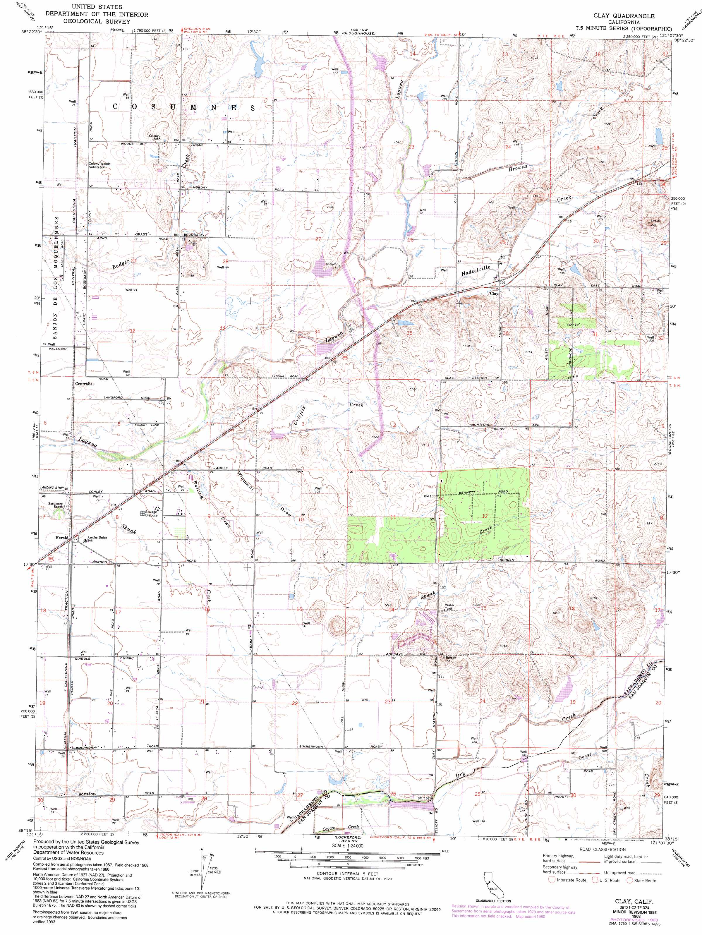
USGS Topo Quad 38121c2 - 1:24,000 scale
| Topo Map Name: | Clay |
| USGS Topo Quad ID: | 38121c2 |
| Print Size: | ca. 21 1/4" wide x 27" high |
| Southeast Coordinates: | 38.25° N latitude / 121.125° W longitude |
| Map Center Coordinates: | 38.3125° N latitude / 121.1875° W longitude |
| U.S. State: | CA |
| Filename: | o38121c2.jpg |
| Download Map JPG Image: | Clay topo map 1:24,000 scale |
| Map Type: | Topographic |
| Topo Series: | 7.5´ |
| Map Scale: | 1:24,000 |
| Source of Map Images: | United States Geological Survey (USGS) |
| Alternate Map Versions: |
Clay CA 1953, updated 1954 Download PDF Buy paper map Clay CA 1953, updated 1965 Download PDF Buy paper map Clay CA 1968, updated 1972 Download PDF Buy paper map Clay CA 1968, updated 1972 Download PDF Buy paper map Clay CA 1968, updated 1977 Download PDF Buy paper map Clay CA 1968, updated 1977 Download PDF Buy paper map Clay CA 1968, updated 1980 Download PDF Buy paper map Clay CA 1968, updated 1980 Download PDF Buy paper map Clay CA 1968, updated 1993 Download PDF Buy paper map Clay CA 2012 Download PDF Buy paper map Clay CA 2015 Download PDF Buy paper map |
1:24,000 Topo Quads surrounding Clay
Sacramento East |
Carmichael |
Buffalo Creek |
Folsom Se |
Latrobe |
Florin |
Elk Grove |
Sloughhouse |
Carbondale |
Irish Hill |
Bruceville |
Galt |
Clay |
Goose Creek |
Ione |
Thornton |
Lodi North |
Lockeford |
Clements |
Wallace |
Terminous |
Lodi South |
Waterloo |
Linden |
Valley Springs Sw |
> Back to 38121a1 at 1:100,000 scale
> Back to 38120a1 at 1:250,000 scale
> Back to U.S. Topo Maps home
Clay topo map: Gazetteer
Clay: Populated Places
Centralia elevation 20m 65′Cicero (historical) elevation 28m 91′
Clay elevation 32m 104′
Conley (historical) elevation 24m 78′
Herald elevation 22m 72′
Clay: Post Offices
Herald Post Office elevation 22m 72′Clay: Streams
Browns Creek elevation 27m 88′Griffith Creek elevation 20m 65′
Hadselville Creek elevation 22m 72′
Clay: Valleys
Rolling Draw elevation 20m 65′Windmill Draw elevation 19m 62′
Clay digital topo map on disk
Buy this Clay topo map showing relief, roads, GPS coordinates and other geographical features, as a high-resolution digital map file on DVD: