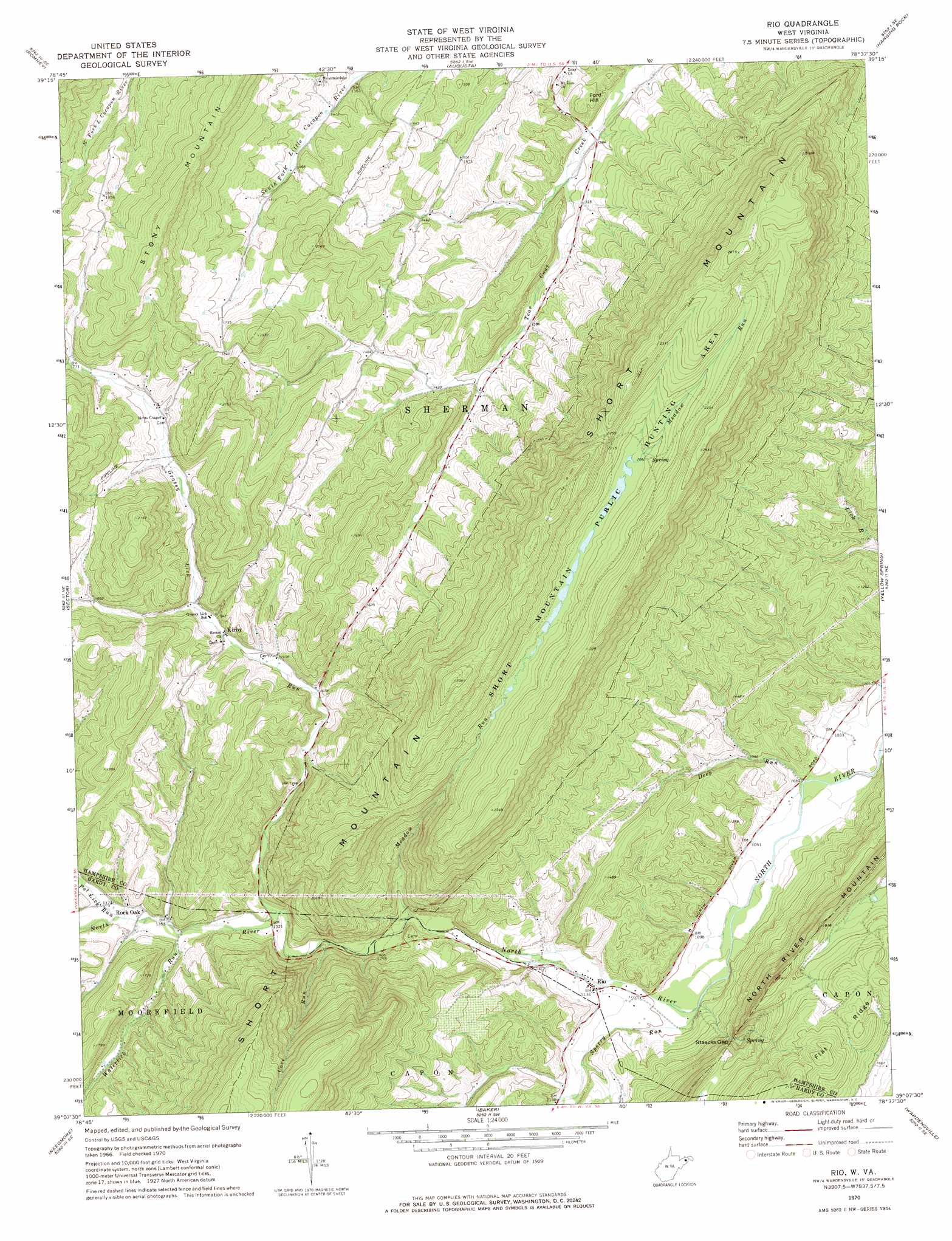
Rio Topo Map West Virginia
To zoom in, hover over the map of Rio
USGS Topo Quad 39078b6 - 1:24,000 scale
| Topo Map Name: | Rio |
| USGS Topo Quad ID: | 39078b6 |
| Print Size: | ca. 21 1/4" wide x 27" high |
| Southeast Coordinates: | 39.125° N latitude / 78.625° W longitude |
| Map Center Coordinates: | 39.1875° N latitude / 78.6875° W longitude |
| U.S. State: | WV |
| Filename: | o39078b6.jpg |
| Download Map JPG Image: | Rio topo map 1:24,000 scale |
| Map Type: | Topographic |
| Topo Series: | 7.5´ |
| Map Scale: | 1:24,000 |
| Source of Map Images: | United States Geological Survey (USGS) |
| Alternate Map Versions: |
Rio WV 1970 Download PDF Buy paper map Rio WV 1970, updated 1974 Download PDF Buy paper map Rio WV 2011 Download PDF Buy paper map Rio WV 2014 Download PDF Buy paper map Rio WV 2016 Download PDF Buy paper map |
1:24,000 Topo Quads surrounding Rio
Keyser |
Headsville |
Springfield |
Levels |
Largent |
Burlington |
Romney |
Augusta |
Hanging Rock |
Capon Bridge |
Old Fields |
Sector |
Rio |
Yellow Spring |
Capon Springs |
Moorefield |
Needmore |
Baker |
Wardensville |
Mountain Falls |
Lost River State Park |
Lost City |
Wolf Gap |
Woodstock |
Toms Brook |
> Back to 39078a1 at 1:100,000 scale
> Back to 39078a1 at 1:250,000 scale
> Back to U.S. Topo Maps home
Rio topo map: Gazetteer
Rio: Gaps
Staacks Gap elevation 406m 1332′Rio: Parks
Short Mountain Wildlife Management Area elevation 625m 2050′Rio: Populated Places
Kirby elevation 463m 1519′Rio elevation 344m 1128′
Rock Oak elevation 411m 1348′
Ruckman elevation 440m 1443′
Rio: Post Offices
Kirby Post Office elevation 462m 1515′Rio Post Office elevation 347m 1138′
Rio: Ranges
South Mountain elevation 455m 1492′Rio: Ridges
Flat Ridge elevation 577m 1893′Rio: Springs
Gap Run Spring elevation 443m 1453′Meadow Spring elevation 732m 2401′
Raymond Hawse Spring elevation 591m 1938′
Rio: Streams
Cove Run elevation 386m 1266′Deep Run elevation 310m 1017′
Grassy Lick Run elevation 401m 1315′
Meadow Run elevation 373m 1223′
Pot Lick Run elevation 416m 1364′
Sperry Run elevation 328m 1076′
Waterlick Run elevation 408m 1338′
Rio: Summits
Ford Hill elevation 435m 1427′Rio digital topo map on disk
Buy this Rio topo map showing relief, roads, GPS coordinates and other geographical features, as a high-resolution digital map file on DVD:
 map DVD")