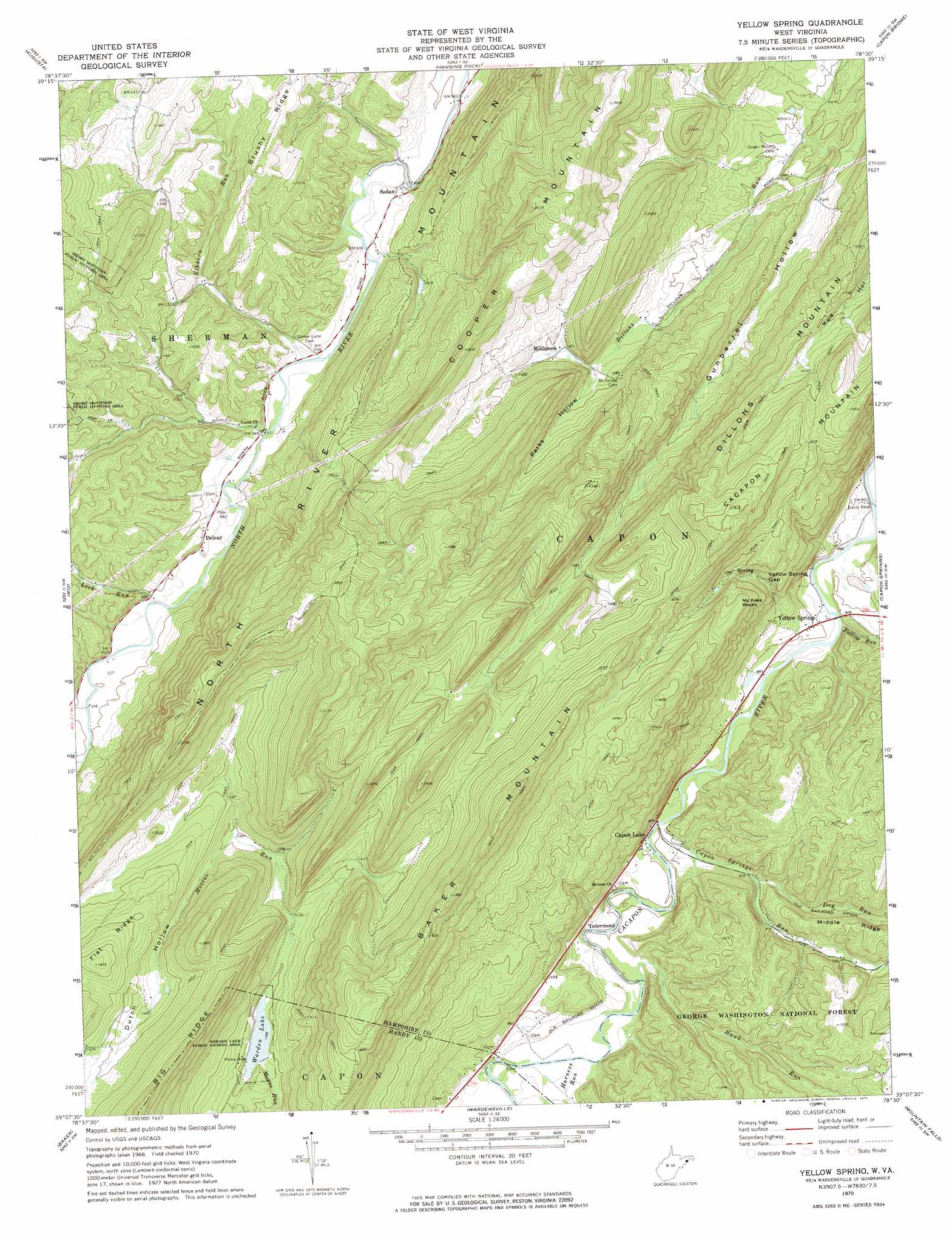
Yellow Spring Topo Map West Virginia
To zoom in, hover over the map of Yellow Spring
USGS Topo Quad 39078b5 - 1:24,000 scale
| Topo Map Name: | Yellow Spring |
| USGS Topo Quad ID: | 39078b5 |
| Print Size: | ca. 21 1/4" wide x 27" high |
| Southeast Coordinates: | 39.125° N latitude / 78.5° W longitude |
| Map Center Coordinates: | 39.1875° N latitude / 78.5625° W longitude |
| U.S. State: | WV |
| Filename: | o39078b5.jpg |
| Download Map JPG Image: | Yellow Spring topo map 1:24,000 scale |
| Map Type: | Topographic |
| Topo Series: | 7.5´ |
| Map Scale: | 1:24,000 |
| Source of Map Images: | United States Geological Survey (USGS) |
| Alternate Map Versions: |
Yellow Spring WV 1970, updated 1974 Download PDF Buy paper map Yellow Spring WV 2011 Download PDF Buy paper map Yellow Spring WV 2014 Download PDF Buy paper map Yellow Spring WV 2016 Download PDF Buy paper map |
| FStopo: | US Forest Service topo Yellow Spring is available: Download FStopo PDF Download FStopo TIF |
1:24,000 Topo Quads surrounding Yellow Spring
Headsville |
Springfield |
Levels |
Largent |
Ridge |
Romney |
Augusta |
Hanging Rock |
Capon Bridge |
Gore |
Sector |
Rio |
Yellow Spring |
Capon Springs |
Hayfield |
Needmore |
Baker |
Wardensville |
Mountain Falls |
Middletown |
Lost City |
Wolf Gap |
Woodstock |
Toms Brook |
Strasburg |
> Back to 39078a1 at 1:100,000 scale
> Back to 39078a1 at 1:250,000 scale
> Back to U.S. Topo Maps home
Yellow Spring topo map: Gazetteer
Yellow Spring: Capes
McKees Rocks elevation 473m 1551′Yellow Spring: Dams
Elkhorn Lake Dam elevation 432m 1417′Warden Lake Dam elevation 384m 1259′
Yellow Spring: Gaps
Yellow Spring Gap elevation 363m 1190′Yellow Spring: Parks
Warden Lake Wildlife Management Area elevation 392m 1286′Yellow Spring: Populated Places
Capon Lake elevation 275m 902′Capon Springs Station (historical) elevation 285m 935′
Davis Ford elevation 260m 853′
Delray elevation 304m 997′
Dillons Run (historical) elevation 330m 1082′
Intermont elevation 284m 931′
Millbrook elevation 387m 1269′
Sedan elevation 290m 951′
Yellow Spring elevation 273m 895′
Yellow Spring: Post Offices
Delray Post Office elevation 306m 1003′Yellow Spring Post Office elevation 270m 885′
Yellow Spring: Reservoirs
Moores Run Lake Number One elevation 384m 1259′Warden Lake elevation 392m 1286′
Yellow Spring: Ridges
Middle Ridge elevation 378m 1240′Pearl Ridge elevation 397m 1302′
Yellow Spring: Springs
Beall Spring elevation 399m 1309′Capon Lake Farm Spring elevation 294m 964′
Cold Spring elevation 281m 921′
Paul Keister Spring elevation 492m 1614′
Yellow Spring elevation 393m 1289′
Yellow Spring: Streams
Capon Springs Run elevation 269m 882′Dry Run elevation 285m 935′
Elkhorn Run elevation 287m 941′
Falling Run elevation 263m 862′
Harness Run elevation 275m 902′
Hawk Run elevation 273m 895′
Lick Run elevation 295m 967′
Yellow Spring: Summits
Baker Mountain elevation 624m 2047′Cacapon Mountain elevation 579m 1899′
Dillons Mountain elevation 584m 1916′
North River Mountain elevation 660m 2165′
Wacousta Hill elevation 384m 1259′
Yellow Spring: Valleys
Gunbarrel Hollow elevation 301m 987′Parks Hollow elevation 377m 1236′
Yellow Spring digital topo map on disk
Buy this Yellow Spring topo map showing relief, roads, GPS coordinates and other geographical features, as a high-resolution digital map file on DVD:
 map DVD")