Leavenworth Topo Map Kansas
To zoom in, hover over the map of Leavenworth
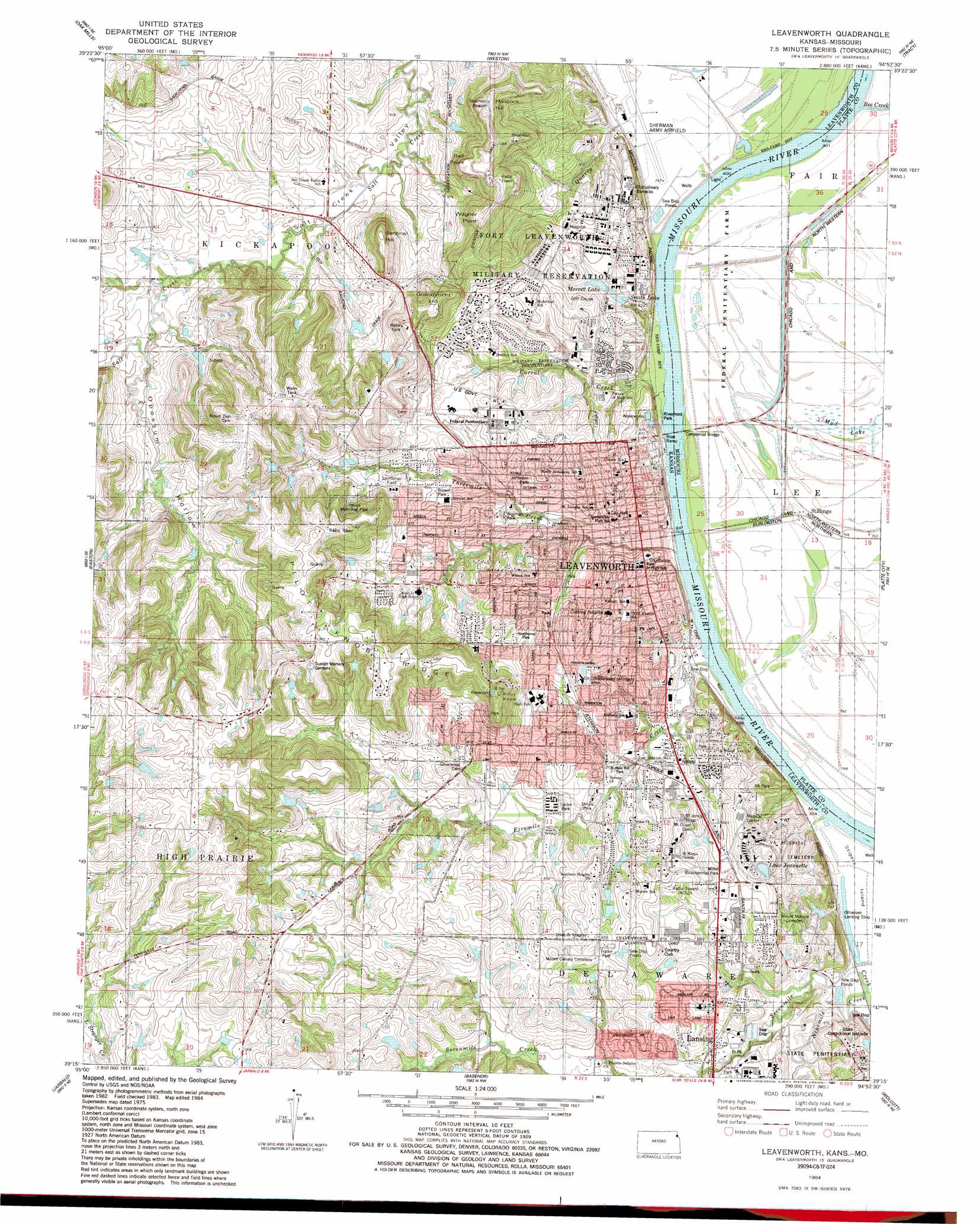
USGS Topo Quad 39094c8 - 1:24,000 scale
| Topo Map Name: | Leavenworth |
| USGS Topo Quad ID: | 39094c8 |
| Print Size: | ca. 21 1/4" wide x 27" high |
| Southeast Coordinates: | 39.25° N latitude / 94.875° W longitude |
| Map Center Coordinates: | 39.3125° N latitude / 94.9375° W longitude |
| U.S. States: | KS, MO |
| Filename: | o39094c8.jpg |
| Download Map JPG Image: | Leavenworth topo map 1:24,000 scale |
| Map Type: | Topographic |
| Topo Series: | 7.5´ |
| Map Scale: | 1:24,000 |
| Source of Map Images: | United States Geological Survey (USGS) |
| Alternate Map Versions: |
Leavenworth KS 1951 Download PDF Buy paper map Leavenworth KS 1951, updated 1951 Download PDF Buy paper map Leavenworth KS 1961, updated 1962 Download PDF Buy paper map Leavenworth KS 1961, updated 1967 Download PDF Buy paper map Leavenworth KS 1961, updated 1971 Download PDF Buy paper map Leavenworth KS 1961, updated 1976 Download PDF Buy paper map Leavenworth KS 1984, updated 1984 Download PDF Buy paper map Leavenworth KS 1984, updated 1991 Download PDF Buy paper map Leavenworth KS 1984, updated 1991 Download PDF Buy paper map Leavenworth KS 2009 Download PDF Buy paper map Leavenworth KS 2012 Download PDF Buy paper map Leavenworth KS 2015 Download PDF Buy paper map |
1:24,000 Topo Quads surrounding Leavenworth
Atchison West |
Atchison East |
De Kalb |
Dearborn |
Edgerton |
Potter |
Oak Mills |
Weston |
Tracy |
Camden Point |
Easton Sw |
Easton |
Leavenworth |
Platte City |
Ferrelview |
Mclouth |
Jarbalo |
Basehor |
Wolcott |
Parkville |
Midland |
Tonganoxie |
Bonner Springs |
Edwardsville |
Shawnee |
> Back to 39094a1 at 1:100,000 scale
> Back to 39094a1 at 1:250,000 scale
> Back to U.S. Topo Maps home
Leavenworth topo map: Gazetteer
Leavenworth: Airports
Blasers Airport elevation 311m 1020′Olhausen Landing Strip elevation 231m 757′
Leavenworth: Bridges
Centennial Bridge elevation 232m 761′Centennial Bridge elevation 232m 761′
Fort Bridge (historical) elevation 232m 761′
Terminal Bridge elevation 232m 761′
Terminal Bridge elevation 232m 761′
Leavenworth: Cliffs
Bell Point elevation 307m 1007′Leavenworth: Guts
Slabtown Slough (historical) elevation 231m 757′Leavenworth: Islands
Leavenworth Island elevation 231m 757′Leavenworth: Parks
Brewer Park elevation 254m 833′Buffalo Bill Park elevation 238m 780′
Haven Memorial Park elevation 306m 1003′
Hawthorne Park elevation 273m 895′
Jefferson Park elevation 256m 839′
Miller Bicentennial Park elevation 267m 875′
Riverfront Park elevation 233m 764′
Shrine Park elevation 249m 816′
Sportsman Field elevation 266m 872′
Veterans Administration Park elevation 262m 859′
Wallman Park elevation 263m 862′
Wollman Park elevation 258m 846′
Leavenworth: Populated Places
Bain City elevation 258m 846′Clear Creek Court Mobile Home Park elevation 241m 790′
Cochrane elevation 232m 761′
Leavenworth elevation 256m 839′
Oak Lane Mobile Home Park elevation 249m 816′
Richardson elevation 253m 830′
Stillings elevation 233m 764′
Wadsworth elevation 257m 843′
Woodmoor Mobile Home Park elevation 252m 826′
Xavier elevation 272m 892′
Zoch Trailer Court elevation 281m 921′
Leavenworth: Post Offices
Fort Leavenworth Post Office elevation 269m 882′Leavenworth Post Office elevation 244m 800′
Leavenworth: Reservoirs
Lake Jeanette elevation 269m 882′Merritt Lake elevation 250m 820′
Smith Lake elevation 245m 803′
Valley Lakes elevation 297m 974′
Leavenworth: Ridges
Pilot Knob Ridge elevation 328m 1076′Leavenworth: Streams
Bee Creek elevation 233m 764′Corral Creek elevation 232m 761′
Fivemile Creek elevation 232m 761′
Ninemile Creek elevation 232m 761′
Quarry Creek elevation 233m 764′
Threemile Creek elevation 233m 764′
Leavenworth: Summits
Government Hill elevation 324m 1062′Hancock Hill elevation 331m 1085′
Pilot Knob elevation 336m 1102′
Sentinel Hill elevation 322m 1056′
Wagner Point elevation 326m 1069′
Leavenworth: Valleys
Opossum Hollow elevation 253m 830′Leavenworth digital topo map on disk
Buy this Leavenworth topo map showing relief, roads, GPS coordinates and other geographical features, as a high-resolution digital map file on DVD: