Junction City Topo Map Kansas
To zoom in, hover over the map of Junction City
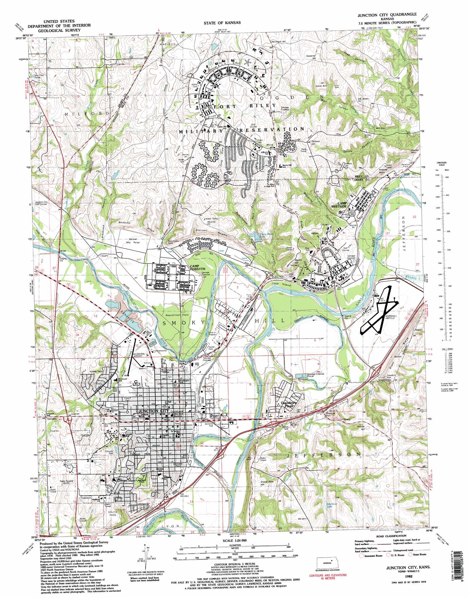
USGS Topo Quad 39096a7 - 1:24,000 scale
| Topo Map Name: | Junction City |
| USGS Topo Quad ID: | 39096a7 |
| Print Size: | ca. 21 1/4" wide x 27" high |
| Southeast Coordinates: | 39° N latitude / 96.75° W longitude |
| Map Center Coordinates: | 39.0625° N latitude / 96.8125° W longitude |
| U.S. State: | KS |
| Filename: | o39096a7.jpg |
| Download Map JPG Image: | Junction City topo map 1:24,000 scale |
| Map Type: | Topographic |
| Topo Series: | 7.5´ |
| Map Scale: | 1:24,000 |
| Source of Map Images: | United States Geological Survey (USGS) |
| Alternate Map Versions: |
Junction City KS 1950 Download PDF Buy paper map Junction City KS 1955, updated 1958 Download PDF Buy paper map Junction City KS 1955, updated 1978 Download PDF Buy paper map Junction City KS 1982, updated 1982 Download PDF Buy paper map Junction City KS 2009 Download PDF Buy paper map Junction City KS 2012 Download PDF Buy paper map Junction City KS 2016 Download PDF Buy paper map |
1:24,000 Topo Quads surrounding Junction City
Clay Center Se |
Bala |
Riley |
Olsburg Sw |
Tuttle Creek Dam |
Wakefield |
Milford |
Fort Riley Ne |
Keats |
Manhattan |
Upland |
Milford Dam |
Junction City |
Ogden |
Swede Creek |
Chapman |
Kansas Falls |
Wreford |
White City Nw |
White City Ne |
Navarre |
Woodbine |
Skiddy |
White City |
Dwight |
> Back to 39096a1 at 1:100,000 scale
> Back to 39096a1 at 1:250,000 scale
> Back to U.S. Topo Maps home
Junction City topo map: Gazetteer
Junction City: Airports
Junction City Municipal Airport elevation 333m 1092′Marshall Airfield elevation 324m 1062′
Junction City: Bridges
Engineer Bridge elevation 317m 1040′Junction City: Cliffs
Backstop Ridge elevation 349m 1145′Pawnee Point elevation 347m 1138′
Republican Point elevation 347m 1138′
Sheridan Point elevation 361m 1184′
Sherman Heights elevation 367m 1204′
Williston Point elevation 377m 1236′
Junction City: Dams
Breakneck Dam elevation 358m 1174′Camp Moon Lake Dam elevation 343m 1125′
Rimrock Dam elevation 354m 1161′
Junction City: Flats
Pawnee Flats elevation 325m 1066′Republican Flats elevation 326m 1069′
The Island elevation 323m 1059′
Wild Glen elevation 350m 1148′
Junction City: Parks
Cleary Park elevation 339m 1112′Coronado Park elevation 335m 1099′
Filby Park elevation 340m 1115′
Freedom Park elevation 356m 1167′
Mullins Park elevation 324m 1062′
Pawnee Park elevation 330m 1082′
Rimrock Park elevation 357m 1171′
Sertoma Park elevation 324m 1062′
South Park elevation 383m 1256′
Wyman Park elevation 331m 1085′
Junction City: Populated Places
Grandview Plaza elevation 345m 1131′Junction City elevation 337m 1105′
Junction City: Reservoirs
Breakneck Lake elevation 358m 1174′Cameron Springs Lake elevation 369m 1210′
Camp Moon Lake elevation 343m 1125′
Idle Hour Lake elevation 360m 1181′
Junction City Reservoir elevation 354m 1161′
Junction City: Ridges
Arnold Divide elevation 406m 1332′Grant Ridge elevation 365m 1197′
Saddle Back elevation 386m 1266′
Junction City: Streams
Dixon Creek elevation 345m 1131′Fourmile Creek elevation 326m 1069′
Franks Creek elevation 323m 1059′
Onemile Creek elevation 319m 1046′
Republican River elevation 318m 1043′
Smoky Hill River elevation 317m 1040′
Junction City: Summits
Artillery Hill elevation 396m 1299′Battery Hill elevation 386m 1266′
Caisson Hill elevation 404m 1325′
Carpenter Hill elevation 398m 1305′
Custer Hill elevation 412m 1351′
Four Way Divide elevation 412m 1351′
Franks Hill elevation 399m 1309′
Grand View Hill elevation 392m 1286′
Harvey Hill elevation 404m 1325′
Machine Gun Ridge elevation 395m 1295′
Macomb Hill elevation 393m 1289′
Morris Hill elevation 408m 1338′
Ogden Hill elevation 377m 1236′
Randolph Hill elevation 403m 1322′
Taylor Point elevation 394m 1292′
Junction City: Valleys
Breakneck Canyon elevation 335m 1099′Coyote Canyon elevation 337m 1105′
Deep Canyon elevation 330m 1082′
Governor Harvey Canyon elevation 335m 1099′
Long Draw elevation 372m 1220′
Magazine Canyon elevation 331m 1085′
Price Ravine elevation 329m 1079′
Pumphouse Canyon elevation 330m 1082′
Rock Springs Canyon elevation 351m 1151′
Wolf Canyon elevation 335m 1099′
Junction City digital topo map on disk
Buy this Junction City topo map showing relief, roads, GPS coordinates and other geographical features, as a high-resolution digital map file on DVD: