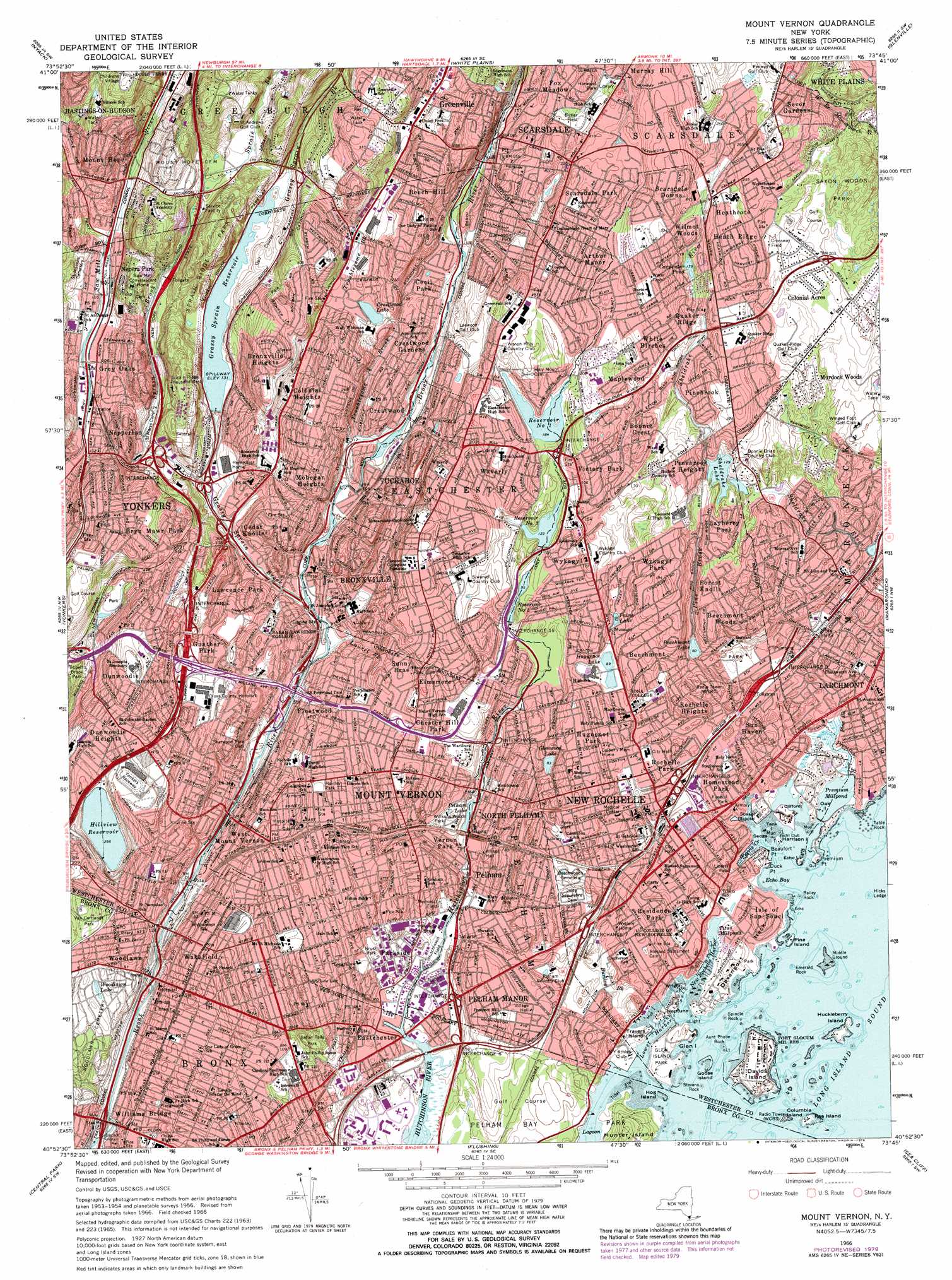
Mount Vernon Topo Map New York
To zoom in, hover over the map of Mount Vernon
USGS Topo Quad 40073h7 - 1:24,000 scale
| Topo Map Name: | Mount Vernon |
| USGS Topo Quad ID: | 40073h7 |
| Print Size: | ca. 21 1/4" wide x 27" high |
| Southeast Coordinates: | 40.875° N latitude / 73.75° W longitude |
| Map Center Coordinates: | 40.9375° N latitude / 73.8125° W longitude |
| U.S. State: | NY |
| Filename: | o40073h7.jpg |
| Download Map JPG Image: | Mount Vernon topo map 1:24,000 scale |
| Map Type: | Topographic |
| Topo Series: | 7.5´ |
| Map Scale: | 1:24,000 |
| Source of Map Images: | United States Geological Survey (USGS) |
| Alternate Map Versions: |
Mt Vernon NY 1947 Download PDF Buy paper map Mount Vernon NY 1956, updated 1958 Download PDF Buy paper map Mount Vernon NY 1956, updated 1965 Download PDF Buy paper map Mount Vernon NY 1966, updated 1970 Download PDF Buy paper map Mount Vernon NY 1966, updated 1977 Download PDF Buy paper map Mount Vernon NY 1966, updated 1979 Download PDF Buy paper map Mount Vernon NY 1966, updated 1979 Download PDF Buy paper map Mount Vernon NY 1995, updated 1999 Download PDF Buy paper map Mount Vernon NY 2010 Download PDF Buy paper map Mount Vernon NY 2013 Download PDF Buy paper map Mount Vernon NY 2016 Download PDF Buy paper map |
1:24,000 Topo Quads surrounding Mount Vernon
Thiells |
Haverstraw |
Ossining |
Mount Kisco |
Pound Ridge |
Park Ridge |
Nyack |
White Plains |
Glenville |
Stamford |
Hackensack |
Yonkers |
Mount Vernon |
Mamaroneck |
Bayville |
Weehawken |
Central Park |
Flushing |
Sea Cliff |
Hicksville |
Jersey City |
Brooklyn |
Jamaica |
Lynbrook |
Freeport |
> Back to 40073e1 at 1:100,000 scale
> Back to 40072a1 at 1:250,000 scale
> Back to U.S. Topo Maps home
Mount Vernon topo map: Gazetteer
Mount Vernon: Areas
Pond Field (historical) elevation 28m 91′Mount Vernon: Bars
Aunt Phebe Rock elevation 2m 6′Bailey Rock elevation 0m 0′
Emerald Rock elevation 0m 0′
Hicks Ledge elevation 0m 0′
Middle Ground elevation 1m 3′
Spindle Rock elevation 1m 3′
Stevens Rock elevation 2m 6′
Table Rock elevation 0m 0′
Mount Vernon: Bays
Echo Bay elevation 0m 0′Mount Vernon: Bridges
Deverman's Bridge elevation 42m 137′Hoyt's Bridge elevation 0m 0′
Hunt's Bridge (historical) elevation 0m 0′
Scott's Bridge elevation 44m 144′
Mount Vernon: Capes
Beaufort Point elevation 0m 0′Davenport Neck elevation 5m 16′
Duck Point elevation 0m 0′
Premium Point elevation 1m 3′
Mount Vernon: Crossings
Interchange 10 elevation 5m 16′Interchange 12 elevation 13m 42′
Interchange 13 elevation 15m 49′
Interchange 14 elevation 21m 68′
Interchange 15 elevation 27m 88′
Interchange 16 elevation 40m 131′
Interchange 17 elevation 42m 137′
Interchange 18 elevation 48m 157′
Interchange 19 elevation 67m 219′
Interchange 20 elevation 67m 219′
Interchange 21 elevation 55m 180′
Interchange 22 elevation 59m 193′
Interchange 4 elevation 50m 164′
Interchange 5 elevation 60m 196′
Interchange 6 elevation 36m 118′
Interchange 6 elevation 9m 29′
Interchange 7 elevation 22m 72′
Interchange 7 elevation 14m 45′
Interchange 8 elevation 18m 59′
Interchange 8 elevation 6m 19′
Interchange 9 elevation 4m 13′
Interchange 9 elevation 9m 29′
Mount Vernon: Harbors
Ferris Creek elevation 0m 0′Lower Harbor elevation 0m 0′
New Rochelle Harbor elevation 0m 0′
Mount Vernon: Islands
Clifford Island elevation 3m 9′Columbia Island elevation 0m 0′
Davids Island elevation 5m 16′
Echo Island elevation 3m 9′
Glen Island elevation 5m 16′
Goose Island elevation 3m 9′
Harrison Island elevation 0m 0′
Hog Island elevation 3m 9′
Huckleberry Island elevation 3m 9′
Hunter Island elevation 25m 82′
Neptune Island elevation 2m 6′
Oak Island elevation 2m 6′
Pea Island elevation 2m 6′
Pine Island elevation 0m 0′
Sedge Island elevation 0m 0′
Tank Island elevation 0m 0′
Travers Island elevation 4m 13′
Wright Island elevation 0m 0′
Mount Vernon: Lakes
Bronxville Lake elevation 24m 78′Crestwood Lake elevation 50m 164′
Paine Lake elevation 27m 88′
Premium Millpond elevation 0m 0′
Sheldrake Lake elevation 36m 118′
Titus Millpond elevation 0m 0′
Woodlawn Lake elevation 50m 164′
Mount Vernon: Mines
Benedict Marble Quarry (historical) elevation 0m 0′Mount Vernon: Parks
A Z Hogan Park elevation 0m 0′Addison Park elevation 13m 42′
Agnes Haywood Playground elevation 40m 131′
Aiello Park elevation 6m 19′
Albert P Richter Park elevation 33m 108′
Andrews Court elevation 63m 206′
Beechmont Oval elevation 26m 85′
Boniface Circle elevation 48m 157′
Bregano Memorial Park elevation 57m 187′
Brom Dyckman Park elevation 45m 147′
Brush Memorial Park elevation 18m 59′
Butler Field elevation 59m 193′
Cerone Avenue Park elevation 83m 272′
Chase Road Park elevation 50m 164′
City Park elevation 9m 29′
Cohn Park elevation 50m 164′
Corell Park elevation 62m 203′
Coyne Park elevation 61m 200′
Crossway Field elevation 62m 203′
Davenport Park elevation 6m 19′
Davis Park elevation 77m 252′
De Lima Park elevation 55m 180′
D'Onofrio Park elevation 6m 19′
Dunwoodie Park elevation 55m 180′
Eastchester Memorial Park elevation 73m 239′
Edenwald Playground elevation 39m 127′
Faneuil Park elevation 6m 19′
Farnsworth Park elevation 42m 137′
Feeny Park elevation 30m 98′
Five Islands Park elevation 0m 0′
Flowers Park elevation 13m 42′
Foy Park elevation 11m 36′
Glen Island Park elevation 4m 13′
Glenhill Avenue Park And Playground elevation 89m 291′
Glover's Field elevation 4m 13′
H F Redmond Junior Memorial Park elevation 43m 141′
Hartley Park elevation 32m 104′
Harwood Park elevation 58m 190′
Henning Park elevation 49m 160′
Hillside Park Playground elevation 55m 180′
Hudson Park elevation 3m 9′
Huguenot Park elevation 21m 68′
Hunt Woods Park elevation 31m 101′
Hyatt Field elevation 0m 0′
James P Scotti Junior Park elevation 24m 78′
John E Andrus Memorial Park elevation 27m 88′
Joseph Kardash Parklet elevation 0m 0′
Kane Avenue Park elevation 0m 0′
Lefurgy Park elevation 71m 232′
Leif Erickson Park elevation 5m 16′
Lester Park elevation 25m 82′
Liberty Park elevation 3m 9′
Lincoln Park elevation 21m 68′
Lorenzen Street Park elevation 2m 6′
Mann Park elevation 30m 98′
Maura Lawn elevation 17m 55′
Mazzella Field elevation 16m 52′
Memorial Field elevation 8m 26′
Monsignor Fermi Park elevation 85m 278′
Music Terrace elevation 65m 213′
Neptune Park elevation 3m 9′
Parkway Field elevation 23m 75′
Raymond Leroy Williams Park elevation 46m 150′
Redmond Field elevation 42m 137′
Rice Oval elevation 22m 72′
Richard W Schultze Memorial Park elevation 37m 121′
Rienzi Playground elevation 47m 154′
Roosevelt Square elevation 37m 121′
Roosevelt Square elevation 26m 85′
Rory O'Moore Parklet elevation 94m 308′
Saint Pauls Church National Historic Site elevation 5m 16′
Saxon Woods Park elevation 55m 180′
September 11 Memorial Park elevation 17m 55′
Seton Falls Park elevation 20m 65′
Sprain Ridge Park elevation 99m 324′
Stars And Stripes Playground elevation 29m 95′
Station Park Plaza elevation 14m 45′
Stephenson Park elevation 7m 22′
Stillwell Park elevation 45m 147′
Sunnybrook Park elevation 42m 137′
Sycamore Park elevation 33m 108′
The Lawn elevation 15m 49′
Titus Mill Pond State Tidal Wetlands elevation 0m 0′
Trenchard Street Park elevation 64m 209′
Uniontown Playground elevation 62m 203′
Vanderberg Park elevation 11m 36′
Victory Park elevation 63m 206′
Villa Park elevation 40m 131′
Village Hall Park elevation 17m 55′
Wakefield Park elevation 23m 75′
Wakefield Playground elevation 46m 150′
Willsons Woods Park elevation 21m 68′
Mount Vernon: Populated Places
Arthur Manor elevation 70m 229′Bayberry Park elevation 48m 157′
Baychester Houses elevation 39m 127′
Beech Hill elevation 88m 288′
Beechmont elevation 32m 104′
Beechmont Woods elevation 29m 95′
Beverly Crest elevation 80m 262′
Bonnie Crest elevation 58m 190′
Bronxville elevation 28m 91′
Bronxville Heights elevation 105m 344′
Bryn Mawr Park elevation 91m 298′
Cecil Park elevation 39m 127′
Cedar Knolls elevation 45m 147′
Chester Heights elevation 24m 78′
Chester Hill Park elevation 39m 127′
Colonial Acres elevation 60m 196′
Colonial Heights elevation 60m 196′
Cotswold elevation 99m 324′
Crestwood elevation 47m 154′
Crestwood Gardens elevation 46m 150′
Dunwoodie elevation 79m 259′
Dunwoodie Heights elevation 84m 275′
Eastchester elevation 7m 22′
Eastchester elevation 16m 52′
Eastchester Heights elevation 42m 137′
Edenwald Houses elevation 41m 134′
Elmsmere elevation 52m 170′
Empire Park elevation 60m 196′
Fleetwood elevation 48m 157′
Forest Heights elevation 40m 131′
Forest Knolls elevation 43m 141′
Gramatan Hills elevation 81m 265′
Greenville elevation 76m 249′
Grey Oaks elevation 37m 121′
Gun Hill Houses elevation 32m 104′
Gunther Park elevation 46m 150′
Halcyon Park elevation 15m 49′
Heath Ridge elevation 79m 259′
Heathcote elevation 74m 242′
Homestead Park elevation 6m 19′
Huguenot Park elevation 34m 111′
Isle of San Souci elevation 10m 32′
Larchmont elevation 16m 52′
Lawrence Park elevation 34m 111′
Lincoln Heights elevation 51m 167′
Maplewood elevation 62m 203′
McLean Heights elevation 49m 160′
Mohegan Heights elevation 44m 144′
Moorelands elevation 43m 141′
Mount Hope elevation 77m 252′
Mount Vernon elevation 34m 111′
Murdock Woods elevation 39m 127′
Murray Hill elevation 63m 206′
Nepera Park elevation 37m 121′
Nepperhan elevation 53m 173′
Nepperhan Heights elevation 88m 288′
New Rochelle elevation 26m 85′
North Pelham elevation 15m 49′
Parkside elevation 14m 45′
Pelham elevation 22m 72′
Pelham Manor elevation 19m 62′
Pinckney Heights elevation 36m 118′
Pine Brook elevation 13m 42′
Pinebrook elevation 63m 206′
Pinebrook Heights elevation 45m 147′
Quaker Ridge elevation 68m 223′
Residence Park elevation 10m 32′
Rochelle Heights elevation 28m 91′
Rochelle Park elevation 20m 65′
Rosedale elevation 12m 39′
Scarsdale Downs elevation 88m 288′
Scarsdale Park elevation 74m 242′
Secor Gardens elevation 63m 206′
Sun Haven elevation 12m 39′
Sunny Brae elevation 41m 134′
Tuckahoe elevation 34m 111′
Vernon Park elevation 13m 42′
Victory Park elevation 62m 203′
Wakefield elevation 45m 147′
Waverly elevation 61m 200′
West Mount Vernon elevation 37m 121′
White Birches elevation 70m 229′
Williams Bridge elevation 31m 101′
Wilmot Woods elevation 71m 232′
Woodlawn elevation 43m 141′
Woodside elevation 19m 62′
Wykagyl elevation 39m 127′
Wykagyl Park elevation 47m 154′
Mount Vernon: Post Offices
Bronxville Post Office elevation 28m 91′Centuck Station Yonkers Post Office elevation 50m 164′
East Station Yonkers Post Office elevation 69m 226′
Fleetwood Station Mount Vernon Post Office elevation 45m 147′
Larchmont Post Office elevation 11m 36′
Mount Vernon Post Office elevation 36m 118′
New Rochelle Post Office elevation 27m 88′
Pelham Post Office elevation 16m 52′
Scarsdale Post Office elevation 47m 154′
Tuckahoe Post Office elevation 32m 104′
Wakefield Station Bronx Post Office elevation 51m 167′
Williamsbridge Station Bronx Post Office elevation 31m 101′
Woodlawn Station Bronx Post Office elevation 48m 157′
Wykagyl Station New Rochelle Post Office elevation 43m 141′
Mount Vernon: Reservoirs
Beechmont Lake elevation 18m 59′Carpenter Pond elevation 54m 177′
Crane Pond elevation 67m 219′
Crystal Lake (historical) elevation 7m 22′
Duck Pond elevation 70m 229′
Fort Field Reservoir (historical) elevation 97m 318′
Glenwood Lake elevation 24m 78′
Grassy Sprain Reservoir elevation 39m 127′
Hillview Reservoir elevation 89m 291′
Huguenot Lake elevation 21m 68′
Lake Ida elevation 0m 0′
Neptune Pond elevation 0m 0′
Pelham Lake elevation 13m 42′
Reservoir Number One elevation 50m 164′
Reservoir Number Three elevation 37m 121′
Reservoir Number Two elevation 30m 98′
Mount Vernon: Springs
Gramatan Springs elevation 28m 91′Mount Vernon: Streams
Burling Brook elevation 5m 16′Grassy Sprain Brook elevation 22m 72′
Laurel Brook elevation 22m 72′
New Rochelle Creek elevation 2m 6′
Pine Brook elevation 41m 134′
Premium River elevation 0m 0′
Sprain Brook elevation 31m 101′
Troublesome Brook elevation 28m 91′
Mount Vernon: Summits
Cronins Hill elevation 65m 213′Post Hill elevation 98m 321′
Valentine Hill elevation 98m 321′
Mount Vernon: Swamps
Great Swamp (historical) elevation 17m 55′Mount Vernon digital topo map on disk
Buy this Mount Vernon topo map showing relief, roads, GPS coordinates and other geographical features, as a high-resolution digital map file on DVD:
Atlantic Coast (NY, NJ, PA, DE, MD, VA, NC)
Buy digital topo maps: Atlantic Coast (NY, NJ, PA, DE, MD, VA, NC)
 map DVD")