Mount Kisco Topo Map New York
To zoom in, hover over the map of Mount Kisco
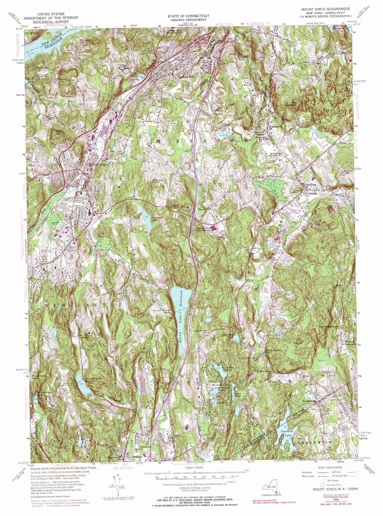
USGS Topo Quad 41073b6 - 1:24,000 scale
| Topo Map Name: | Mount Kisco |
| USGS Topo Quad ID: | 41073b6 |
| Print Size: | ca. 21 1/4" wide x 27" high |
| Southeast Coordinates: | 41.125° N latitude / 73.625° W longitude |
| Map Center Coordinates: | 41.1875° N latitude / 73.6875° W longitude |
| U.S. States: | NY, CT |
| Filename: | o41073b6.jpg |
| Download Map JPG Image: | Mount Kisco topo map 1:24,000 scale |
| Map Type: | Topographic |
| Topo Series: | 7.5´ |
| Map Scale: | 1:24,000 |
| Source of Map Images: | United States Geological Survey (USGS) |
| Alternate Map Versions: |
Mount Kisco NY 1955, updated 1956 Download PDF Buy paper map Mount Kisco NY 1955, updated 1961 Download PDF Buy paper map Mount Kisco NY 1955, updated 1968 Download PDF Buy paper map Mount Kisco NY 1955, updated 1973 Download PDF Buy paper map Mount Kisco NY 1955, updated 1990 Download PDF Buy paper map Mount Kisco NY 1998, updated 2001 Download PDF Buy paper map Mount Kisco NY 2010 Download PDF Buy paper map Mount Kisco NY 2013 Download PDF Buy paper map Mount Kisco NY 2016 Download PDF Buy paper map |
1:24,000 Topo Quads surrounding Mount Kisco
West Point |
Oscawana Lake |
Lake Carmel |
Brewster |
Danbury |
Peekskill |
Mohegan Lake |
Croton Falls |
Peach Lake |
Bethel |
Haverstraw |
Ossining |
Mount Kisco |
Pound Ridge |
Norwalk North |
Nyack |
White Plains |
Glenville |
Stamford |
Norwalk South |
Yonkers |
Mount Vernon |
Mamaroneck |
Bayville |
Lloyd Harbor |
> Back to 41073a1 at 1:100,000 scale
> Back to 41072a1 at 1:250,000 scale
> Back to U.S. Topo Maps home
Mount Kisco topo map: Gazetteer
Mount Kisco: Airports
Harris Hill Heliport elevation 93m 305′La Roe Airport (historical) elevation 110m 360′
Mount Kisco: Areas
Cohansey elevation 127m 416′Mount Kisco: Capes
Burying Point elevation 140m 459′Mount Kisco: Crossings
Interchange 4 elevation 159m 521′Mount Kisco: Dams
Converse Lake Dam elevation 130m 426′Saddle Pond Dam elevation 150m 492′
Mount Kisco: Lakes
Beaver Lake elevation 120m 393′Calder Lake elevation 178m 583′
Cobamong Pond elevation 141m 462′
Converse Lake elevation 130m 426′
Davis Pond elevation 175m 574′
Giffords Lake elevation 133m 436′
Godeman Pond elevation 148m 485′
Heaptaugua Lake elevation 175m 574′
Lake Marie elevation 80m 262′
Long Pond elevation 143m 469′
Mount Kisco: Parks
A L Ehrmann Park and Recreation Center elevation 122m 400′Arthur W Butler Memorial Sanctuary elevation 224m 734′
Beaver Dam Park elevation 103m 337′
Bedford Hills Memorial Park elevation 86m 282′
Bedford Hills Memorial Park elevation 86m 282′
Bedford Village Historic District elevation 109m 357′
Bedford Village Memorial Park elevation 110m 360′
Cat Rocks Park elevation 157m 515′
Choate Audubon Sanctuary elevation 93m 305′
Clark Field elevation 119m 390′
Eugene and Agnes Meyer Nature Preserve elevation 191m 626′
Guard Hill Preserve elevation 193m 633′
Haas Audubon Sanctuary elevation 198m 649′
J Edward Fox Memorial Park elevation 87m 285′
Kirby Plaza elevation 0m 0′
Leonard Park elevation 125m 410′
Lombardi Park elevation 118m 387′
Marsh Memorial Sanctuary elevation 107m 351′
Piney Woods Preserve elevation 104m 341′
Wampus Brook Park elevation 115m 377′
Wampus Lake County Park elevation 138m 452′
Westmoreland Sanctuary elevation 127m 416′
Mount Kisco: Populated Places
Armonk elevation 118m 387′Banksville elevation 138m 452′
Bedford elevation 115m 377′
Bedford Center elevation 117m 383′
Bedford Four Corners elevation 148m 485′
Bedford Hills elevation 104m 341′
Kirbyville elevation 106m 347′
Mount Kisco elevation 93m 305′
North Castle elevation 182m 597′
Stanwood elevation 102m 334′
Windmill Farm elevation 197m 646′
Mount Kisco: Post Offices
Bedford Hills Post Office elevation 87m 285′Mount Kisco: Ranges
Coman Hills elevation 191m 626′Mount Kisco: Reservoirs
Byram Lake Reservoir elevation 136m 446′Converse Lake elevation 132m 433′
Howlands Lake elevation 137m 449′
North Lake elevation 162m 531′
Potters Pond elevation 105m 344′
Saddle Pond elevation 150m 492′
Wampus Lake Reservoir elevation 137m 449′
Whippoorwill Lake elevation 136m 446′
Windmill Lake elevation 189m 620′
Mount Kisco: Ridges
Chestnut Ridge elevation 200m 656′Mount Kisco: Streams
Broad Brook elevation 70m 229′Chappaqua Brook elevation 84m 275′
Shallow Brook elevation 128m 419′
Mount Kisco: Summits
Bull Hill elevation 141m 462′Guard Hill elevation 226m 741′
Halls Hill elevation 186m 610′
Indian Hill elevation 201m 659′
Mount Aspetong elevation 229m 751′
Nonames Hill elevation 246m 807′
Ray Hill elevation 178m 583′
Mount Kisco: Swamps
Cranberry Meadows elevation 90m 295′Mount Kisco digital topo map on disk
Buy this Mount Kisco topo map showing relief, roads, GPS coordinates and other geographical features, as a high-resolution digital map file on DVD:
New York, Vermont, Connecticut & Western Massachusetts
Buy digital topo maps: New York, Vermont, Connecticut & Western Massachusetts