Pound Ridge Topo Map New York
To zoom in, hover over the map of Pound Ridge
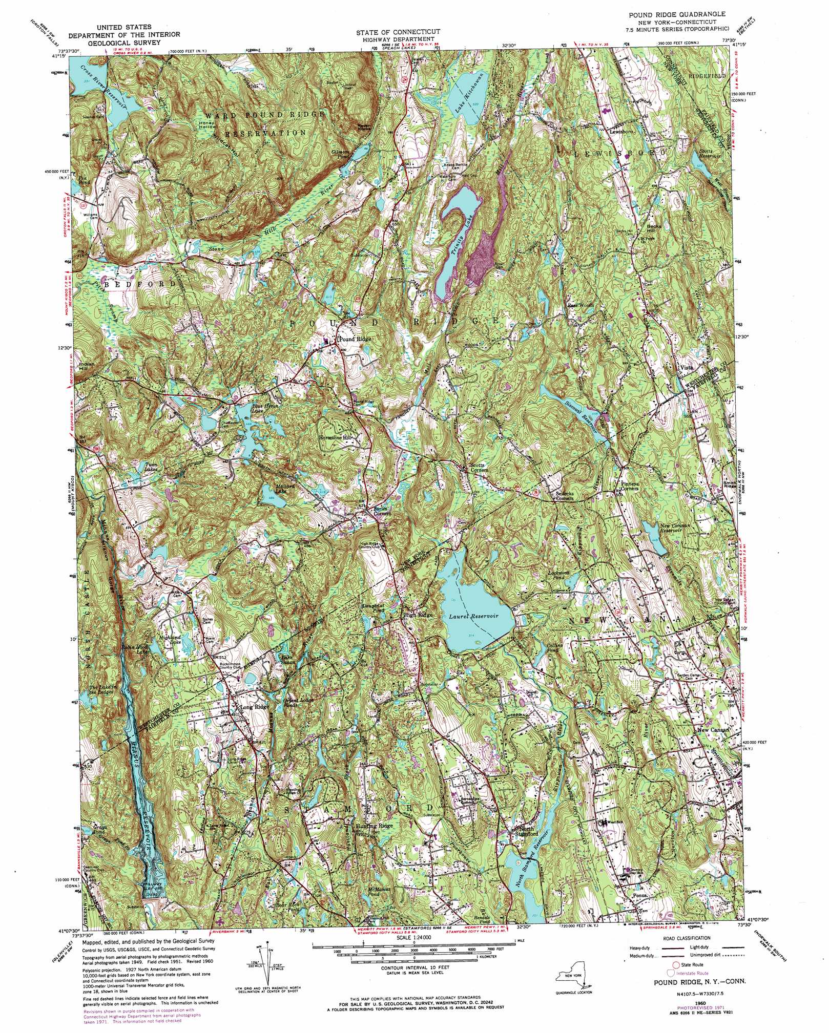
USGS Topo Quad 41073b5 - 1:24,000 scale
| Topo Map Name: | Pound Ridge |
| USGS Topo Quad ID: | 41073b5 |
| Print Size: | ca. 21 1/4" wide x 27" high |
| Southeast Coordinates: | 41.125° N latitude / 73.5° W longitude |
| Map Center Coordinates: | 41.1875° N latitude / 73.5625° W longitude |
| U.S. States: | NY, CT |
| Filename: | o41073b5.jpg |
| Download Map JPG Image: | Pound Ridge topo map 1:24,000 scale |
| Map Type: | Topographic |
| Topo Series: | 7.5´ |
| Map Scale: | 1:24,000 |
| Source of Map Images: | United States Geological Survey (USGS) |
| Alternate Map Versions: |
Pound Ridge NY 1947 Download PDF Buy paper map Pound Ridge NY 1951, updated 1956 Download PDF Buy paper map Pound Ridge NY 1960, updated 1961 Download PDF Buy paper map Pound Ridge NY 1960, updated 1966 Download PDF Buy paper map Pound Ridge NY 1960, updated 1973 Download PDF Buy paper map Pound Ridge NY 1960, updated 1973 Download PDF Buy paper map Pound Ridge NY 2013 Download PDF Buy paper map Pound Ridge NY 2016 Download PDF Buy paper map |
1:24,000 Topo Quads surrounding Pound Ridge
Oscawana Lake |
Lake Carmel |
Brewster |
Danbury |
Newtown |
Mohegan Lake |
Croton Falls |
Peach Lake |
Bethel |
Botsford |
Ossining |
Mount Kisco |
Pound Ridge |
Norwalk North |
Westport |
White Plains |
Glenville |
Stamford |
Norwalk South |
Sherwood Point |
Mount Vernon |
Mamaroneck |
Bayville |
Lloyd Harbor |
Northport |
> Back to 41073a1 at 1:100,000 scale
> Back to 41072a1 at 1:250,000 scale
> Back to U.S. Topo Maps home
Pound Ridge topo map: Gazetteer
Pound Ridge: Basins
Honey Hollow elevation 148m 485′Pound Ridge: Cliffs
Raven Rocks elevation 179m 587′Pound Ridge: Dams
Cox's Dam elevation 134m 439′Grays Pond Dam elevation 119m 390′
Laurel Reservoir Dam elevation 86m 282′
Mianus Reservoir Dam elevation 64m 209′
New Canaan Reservoir Dam elevation 131m 429′
Siscowit Reservoir Dam elevation 136m 446′
Pound Ridge: Lakes
Collins Pond elevation 79m 259′Doughnut Lake elevation 135m 442′
Highland Lake elevation 136m 446′
Lake Kitchawan elevation 158m 518′
Lake Susan elevation 118m 387′
Lockwood Pond elevation 112m 367′
McManus Lake elevation 71m 232′
Orient Lodge Lake elevation 120m 393′
Pea Pond elevation 131m 429′
The Lake in the Ledges elevation 133m 436′
Twin Lakes elevation 130m 426′
Pound Ridge: Parks
Bartlett Arboretum Historic Preserve elevation 74m 242′Chestnut Hill Park elevation 68m 223′
Halle Ravine Preserve elevation 145m 475′
Long Ridge Village Historic District elevation 134m 439′
Scofield Park elevation 88m 288′
Ward Pound Ridge Reservation elevation 183m 600′
Pound Ridge: Populated Places
East Woods elevation 177m 580′High Ridge elevation 136m 446′
High Ridge elevation 142m 465′
Horseshoe Hill elevation 180m 590′
Lewisboro elevation 222m 728′
Long Ridge elevation 130m 426′
North Stamford elevation 75m 246′
Pinneys Corners elevation 155m 508′
Ponus elevation 101m 331′
Pound Ridge elevation 189m 620′
Sarles Corners elevation 116m 380′
Scotts Corners elevation 121m 396′
Sellecks Corners elevation 139m 456′
Vista elevation 170m 557′
Pound Ridge: Ranges
Candlewood Hills elevation 175m 574′Pound Ridge: Reservoirs
Bear Rock Pond elevation 85m 278′Blue Heron Lake elevation 142m 465′
Gilmore Pond elevation 140m 459′
Grays Pond elevation 119m 390′
Laurel Reservoir elevation 86m 282′
Mallard Lake elevation 145m 475′
Mianus Reservoir elevation 64m 209′
Mianus Reservoir elevation 62m 203′
New Canaan Reservoir elevation 131m 429′
North Stamford Reservoir elevation 59m 193′
Robin Hood Lake elevation 130m 426′
Scotts Reservoir elevation 159m 521′
Siscowit Reservoir elevation 136m 446′
Trinity Lake elevation 137m 449′
Pound Ridge: Ridges
Gibses Ridge elevation 166m 544′Smith Ridge elevation 146m 479′
Pound Ridge: Streams
Grays Pond Brook elevation 80m 262′Mill River elevation 78m 255′
Piping Brook elevation 116m 380′
Piping Brook elevation 113m 370′
Scotts Brook elevation 154m 505′
Pound Ridge: Summits
Becks Hill elevation 208m 682′Burial Hill elevation 156m 511′
Great Hill elevation 177m 580′
Wren Knolls elevation 113m 370′
Pound Ridge: Swamps
Pitch Swamp elevation 124m 406′Pound Ridge: Valleys
Halle Ravine elevation 127m 416′Mianus Gorge elevation 78m 255′
Wildcat Hollow elevation 149m 488′
Pound Ridge digital topo map on disk
Buy this Pound Ridge topo map showing relief, roads, GPS coordinates and other geographical features, as a high-resolution digital map file on DVD:
New York, Vermont, Connecticut & Western Massachusetts
Buy digital topo maps: New York, Vermont, Connecticut & Western Massachusetts