Mount Pleasant Topo Map Indiana
To zoom in, hover over the map of Mount Pleasant
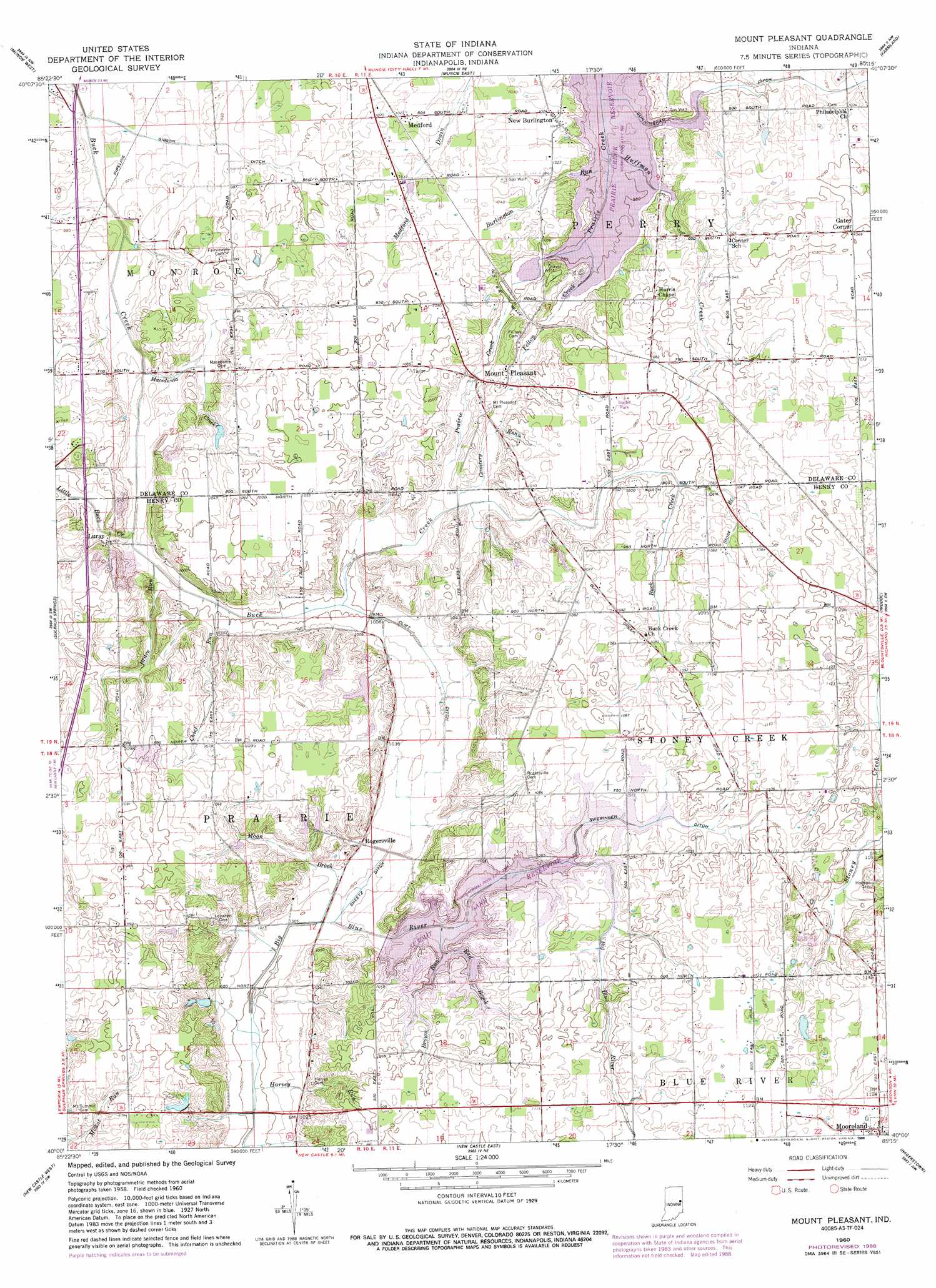
USGS Topo Quad 40085a3 - 1:24,000 scale
| Topo Map Name: | Mount Pleasant |
| USGS Topo Quad ID: | 40085a3 |
| Print Size: | ca. 21 1/4" wide x 27" high |
| Southeast Coordinates: | 40° N latitude / 85.25° W longitude |
| Map Center Coordinates: | 40.0625° N latitude / 85.3125° W longitude |
| U.S. State: | IN |
| Filename: | o40085a3.jpg |
| Download Map JPG Image: | Mount Pleasant topo map 1:24,000 scale |
| Map Type: | Topographic |
| Topo Series: | 7.5´ |
| Map Scale: | 1:24,000 |
| Source of Map Images: | United States Geological Survey (USGS) |
| Alternate Map Versions: |
Mount Pleasant IN 1960, updated 1961 Download PDF Buy paper map Mount Pleasant IN 1960, updated 1980 Download PDF Buy paper map Mount Pleasant IN 1960, updated 1982 Download PDF Buy paper map Mount Pleasant IN 1960, updated 1988 Download PDF Buy paper map Mount Pleasant IN 2010 Download PDF Buy paper map Mount Pleasant IN 2013 Download PDF Buy paper map Mount Pleasant IN 2016 Download PDF Buy paper map |
1:24,000 Topo Quads surrounding Mount Pleasant
Gaston |
Wheeling |
Eaton |
Redkey |
Ridgeville |
Gilman |
Muncie West |
Muncie East |
Farmland |
Maxville |
Middletown |
Sulphur Springs |
Mount Pleasant |
Modoc |
Carlos |
Shirley |
New Castle West |
New Castle East |
Hagerstown |
Greens Fork |
Knightstown |
Dunreith |
Lewisville |
Cambridge City |
Jacksonburg |
> Back to 40085a1 at 1:100,000 scale
> Back to 40084a1 at 1:250,000 scale
> Back to U.S. Topo Maps home
Mount Pleasant topo map: Gazetteer
Mount Pleasant: Airports
Starkeys Airport elevation 340m 1115′Mount Pleasant: Canals
Clift Ditch elevation 306m 1003′Cunningham Ditch elevation 305m 1000′
Gibson Ditch elevation 295m 967′
Sheetz Ditch elevation 307m 1007′
Sweringen Ditch elevation 327m 1072′
Mount Pleasant: Populated Places
Gates Corner elevation 319m 1046′Luray elevation 304m 997′
Medford elevation 312m 1023′
Mount Pleasant elevation 313m 1026′
New Burlington elevation 311m 1020′
Rogersville elevation 312m 1023′
Mount Pleasant: Reservoirs
Summit Lake Reservoir elevation 327m 1072′Mount Pleasant: Streams
Brave Run elevation 299m 980′Brown Run elevation 326m 1069′
Burlington Run elevation 304m 997′
Cemetery Run elevation 309m 1013′
Chief Run elevation 302m 990′
Felton Creek elevation 303m 994′
Harvey Run elevation 303m 994′
Huffman Creek elevation 303m 994′
Little Buck Creek elevation 298m 977′
Macedonia Creek elevation 296m 971′
Moon Brook elevation 307m 1007′
Red Brook elevation 325m 1066′
Stone Branch elevation 318m 1043′
Mount Pleasant digital topo map on disk
Buy this Mount Pleasant topo map showing relief, roads, GPS coordinates and other geographical features, as a high-resolution digital map file on DVD:
Northern Illinois, Northern Indiana & Southwestern Michigan
Buy digital topo maps: Northern Illinois, Northern Indiana & Southwestern Michigan