Muncie West Topo Map Indiana
To zoom in, hover over the map of Muncie West
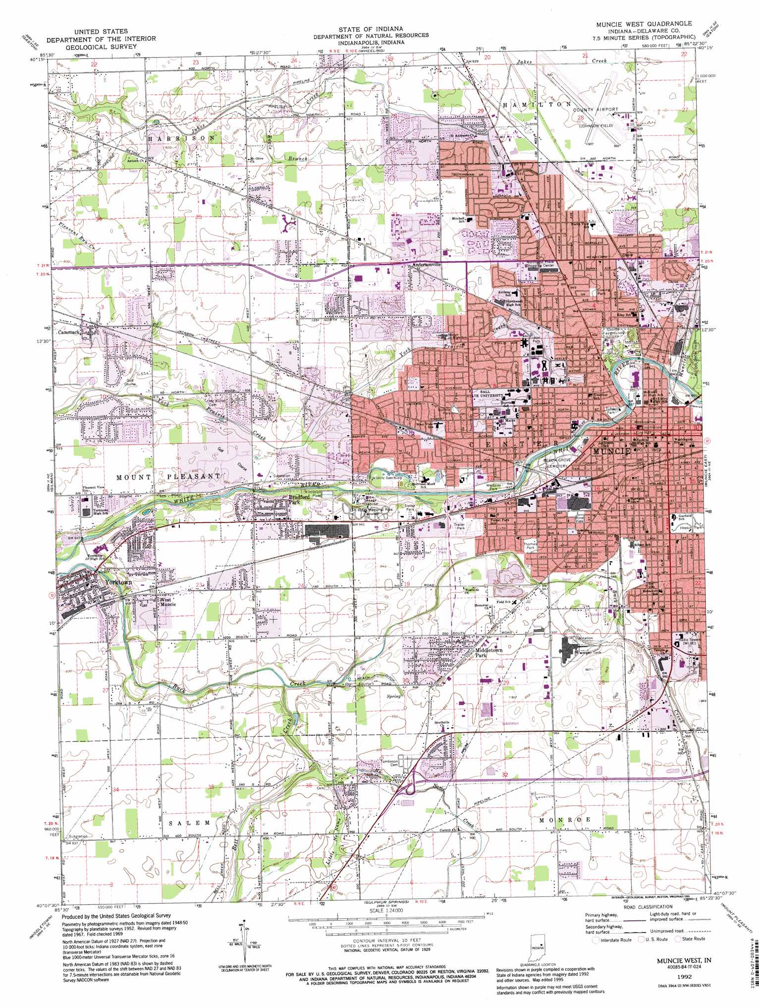
USGS Topo Quad 40085b4 - 1:24,000 scale
| Topo Map Name: | Muncie West |
| USGS Topo Quad ID: | 40085b4 |
| Print Size: | ca. 21 1/4" wide x 27" high |
| Southeast Coordinates: | 40.125° N latitude / 85.375° W longitude |
| Map Center Coordinates: | 40.1875° N latitude / 85.4375° W longitude |
| U.S. State: | IN |
| Filename: | o40085b4.jpg |
| Download Map JPG Image: | Muncie West topo map 1:24,000 scale |
| Map Type: | Topographic |
| Topo Series: | 7.5´ |
| Map Scale: | 1:24,000 |
| Source of Map Images: | United States Geological Survey (USGS) |
| Alternate Map Versions: |
Muncie West IN 1952, updated 1953 Download PDF Buy paper map Muncie West IN 1962, updated 1964 Download PDF Buy paper map Muncie West IN 1969, updated 1971 Download PDF Buy paper map Muncie West IN 1969, updated 1982 Download PDF Buy paper map Muncie West IN 1969, updated 1988 Download PDF Buy paper map Muncie West IN 1992, updated 1995 Download PDF Buy paper map Muncie West IN 1992, updated 1995 Download PDF Buy paper map Muncie West IN 2010 Download PDF Buy paper map Muncie West IN 2013 Download PDF Buy paper map Muncie West IN 2016 Download PDF Buy paper map |
1:24,000 Topo Quads surrounding Muncie West
Fairmount |
Gas City |
Hartford City West |
Hartford City East |
Pennville |
Alexandria |
Gaston |
Wheeling |
Eaton |
Redkey |
Anderson North |
Gilman |
Muncie West |
Muncie East |
Farmland |
Anderson South |
Middletown |
Sulphur Springs |
Mount Pleasant |
Modoc |
Pendleton |
Shirley |
New Castle West |
New Castle East |
Hagerstown |
> Back to 40085a1 at 1:100,000 scale
> Back to 40084a1 at 1:250,000 scale
> Back to U.S. Topo Maps home
Muncie West topo map: Gazetteer
Muncie West: Airports
Delaware County Airport-Johnson Field elevation 284m 931′Muncie West: Canals
Heath Ditch elevation 284m 931′Riggins Ditch elevation 281m 921′
Muncie West: Parks
Bradford Park elevation 285m 935′Cowing Park elevation 289m 948′
Guthrie Park elevation 285m 935′
Heekin Park elevation 293m 961′
John B And June M Scheumann Stadium elevation 285m 935′
McCulloch Park elevation 294m 964′
Rose Park elevation 291m 954′
Thomas Park elevation 289m 948′
Tuhey Park elevation 283m 928′
Westside Park elevation 280m 918′
Muncie West: Populated Places
Andersonville elevation 286m 938′Cammack elevation 284m 931′
Drew elevation 290m 951′
Middletown Park elevation 289m 948′
Muncie elevation 290m 951′
West Muncie elevation 284m 931′
Yorktown elevation 279m 915′
Muncie West: Streams
Bell Creek elevation 280m 918′Eagle Branch elevation 276m 905′
Little No Name Creek elevation 282m 925′
Muncie Creek elevation 282m 925′
No Name Creek elevation 282m 925′
Muncie West digital topo map on disk
Buy this Muncie West topo map showing relief, roads, GPS coordinates and other geographical features, as a high-resolution digital map file on DVD:
Northern Illinois, Northern Indiana & Southwestern Michigan
Buy digital topo maps: Northern Illinois, Northern Indiana & Southwestern Michigan