Alexandria Topo Map Indiana
To zoom in, hover over the map of Alexandria
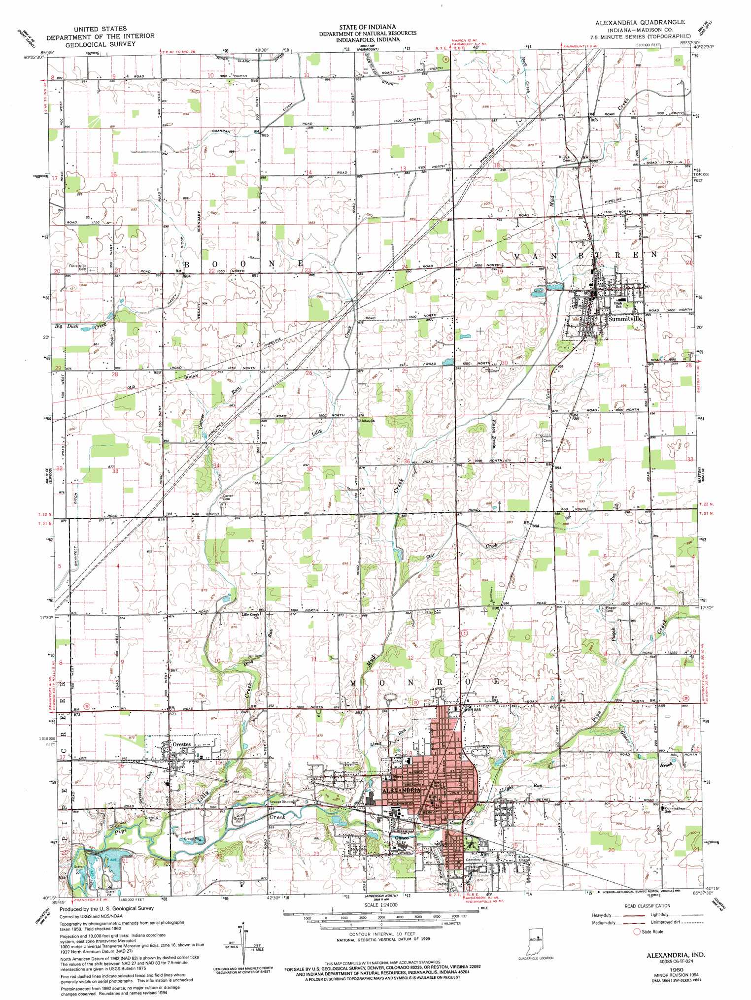
USGS Topo Quad 40085c6 - 1:24,000 scale
| Topo Map Name: | Alexandria |
| USGS Topo Quad ID: | 40085c6 |
| Print Size: | ca. 21 1/4" wide x 27" high |
| Southeast Coordinates: | 40.25° N latitude / 85.625° W longitude |
| Map Center Coordinates: | 40.3125° N latitude / 85.6875° W longitude |
| U.S. State: | IN |
| Filename: | o40085c6.jpg |
| Download Map JPG Image: | Alexandria topo map 1:24,000 scale |
| Map Type: | Topographic |
| Topo Series: | 7.5´ |
| Map Scale: | 1:24,000 |
| Source of Map Images: | United States Geological Survey (USGS) |
| Alternate Map Versions: |
Alexandria IN 1960, updated 1961 Download PDF Buy paper map Alexandria IN 1960, updated 1978 Download PDF Buy paper map Alexandria IN 1960, updated 1994 Download PDF Buy paper map Alexandria IN 2010 Download PDF Buy paper map Alexandria IN 2013 Download PDF Buy paper map Alexandria IN 2016 Download PDF Buy paper map |
1:24,000 Topo Quads surrounding Alexandria
Amboy |
Sweetser |
Marion |
Van Buren |
Roll |
Greentown |
Point Isabel |
Fairmount |
Gas City |
Hartford City West |
Windfall |
Elwood |
Alexandria |
Gaston |
Wheeling |
Omega |
Frankton |
Anderson North |
Gilman |
Muncie West |
Riverwood |
Lapel |
Anderson South |
Middletown |
Sulphur Springs |
> Back to 40085a1 at 1:100,000 scale
> Back to 40084a1 at 1:250,000 scale
> Back to U.S. Topo Maps home
Alexandria topo map: Gazetteer
Alexandria: Canals
Coahran Ditch elevation 270m 885′Hasty Ditch elevation 270m 885′
Jones Clark Ditch elevation 269m 882′
Alexandria: Parks
Beulah Park elevation 266m 872′Alexandria: Populated Places
Alexandria elevation 265m 869′Gimco City elevation 257m 843′
Orestes elevation 266m 872′
Summitville elevation 269m 882′
Alexandria: Streams
Alexandria Creek elevation 258m 846′Beulah Run elevation 261m 856′
Carver Run elevation 263m 862′
Dong Run elevation 262m 859′
Gimco Brook elevation 261m 856′
Light Run elevation 260m 853′
Lilly Creek elevation 253m 830′
Limit Run elevation 258m 846′
Mud Creek elevation 257m 843′
Orestes Run elevation 253m 830′
Pisgah Run elevation 262m 859′
Star Creek elevation 260m 853′
Vinson Drain elevation 262m 859′
Alexandria digital topo map on disk
Buy this Alexandria topo map showing relief, roads, GPS coordinates and other geographical features, as a high-resolution digital map file on DVD:
Northern Illinois, Northern Indiana & Southwestern Michigan
Buy digital topo maps: Northern Illinois, Northern Indiana & Southwestern Michigan