Bluffton Topo Map Indiana
To zoom in, hover over the map of Bluffton
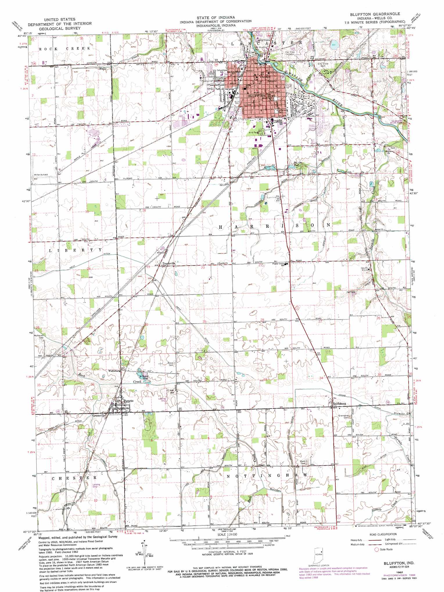
USGS Topo Quad 40085f2 - 1:24,000 scale
| Topo Map Name: | Bluffton |
| USGS Topo Quad ID: | 40085f2 |
| Print Size: | ca. 21 1/4" wide x 27" high |
| Southeast Coordinates: | 40.625° N latitude / 85.125° W longitude |
| Map Center Coordinates: | 40.6875° N latitude / 85.1875° W longitude |
| U.S. State: | IN |
| Filename: | o40085f2.jpg |
| Download Map JPG Image: | Bluffton topo map 1:24,000 scale |
| Map Type: | Topographic |
| Topo Series: | 7.5´ |
| Map Scale: | 1:24,000 |
| Source of Map Images: | United States Geological Survey (USGS) |
| Alternate Map Versions: |
Bluffton IN 1962, updated 1964 Download PDF Buy paper map Bluffton IN 1962, updated 1982 Download PDF Buy paper map Bluffton IN 1962, updated 1988 Download PDF Buy paper map Bluffton IN 2010 Download PDF Buy paper map Bluffton IN 2013 Download PDF Buy paper map Bluffton IN 2016 Download PDF Buy paper map |
1:24,000 Topo Quads surrounding Bluffton
Huntington |
Zanesville |
Ossian |
Poe |
Hoagland |
Majenica |
Markle |
Uniondale |
Preble |
Decatur |
Warren |
Liberty Center |
Bluffton |
Linn Grove |
Berne |
Roll |
Montpelier |
Petroleum |
Domestic |
Geneva |
Hartford City West |
Hartford City East |
Pennville |
Blaine |
Portland |
> Back to 40085e1 at 1:100,000 scale
> Back to 40084a1 at 1:250,000 scale
> Back to U.S. Topo Maps home
Bluffton topo map: Gazetteer
Bluffton: Airports
Brinnemans Headacres Airport elevation 260m 853′Bluffton: Canals
Boyer Ditch elevation 252m 826′Craven Ditch elevation 252m 826′
Crosbie Ditch elevation 253m 830′
Delong Ditch elevation 250m 820′
Irvin Ditch elevation 260m 853′
Johns Ditch elevation 255m 836′
Johnson Ditch elevation 251m 823′
King Ditch elevation 258m 846′
Lambert Ditch elevation 260m 853′
Lee Number Two Ditch elevation 261m 856′
Maddux-Showalter Ditch elevation 260m 853′
Markley Ditch elevation 248m 813′
Popejoy Ditch elevation 253m 830′
Bluffton: Parks
4-H Park elevation 253m 830′Jefferson Park elevation 251m 823′
Washington Park elevation 250m 820′
Bluffton: Populated Places
Bluffton elevation 252m 826′Greenville elevation 259m 849′
Poneto elevation 259m 849′
Reiffsburg elevation 259m 849′
Travisville elevation 257m 843′
Wellsburg elevation 258m 846′
Bluffton: Streams
Elm Creek elevation 256m 839′Johns Creek elevation 254m 833′
Sixmile Creek elevation 246m 807′
Bluffton digital topo map on disk
Buy this Bluffton topo map showing relief, roads, GPS coordinates and other geographical features, as a high-resolution digital map file on DVD:
Northern Illinois, Northern Indiana & Southwestern Michigan
Buy digital topo maps: Northern Illinois, Northern Indiana & Southwestern Michigan