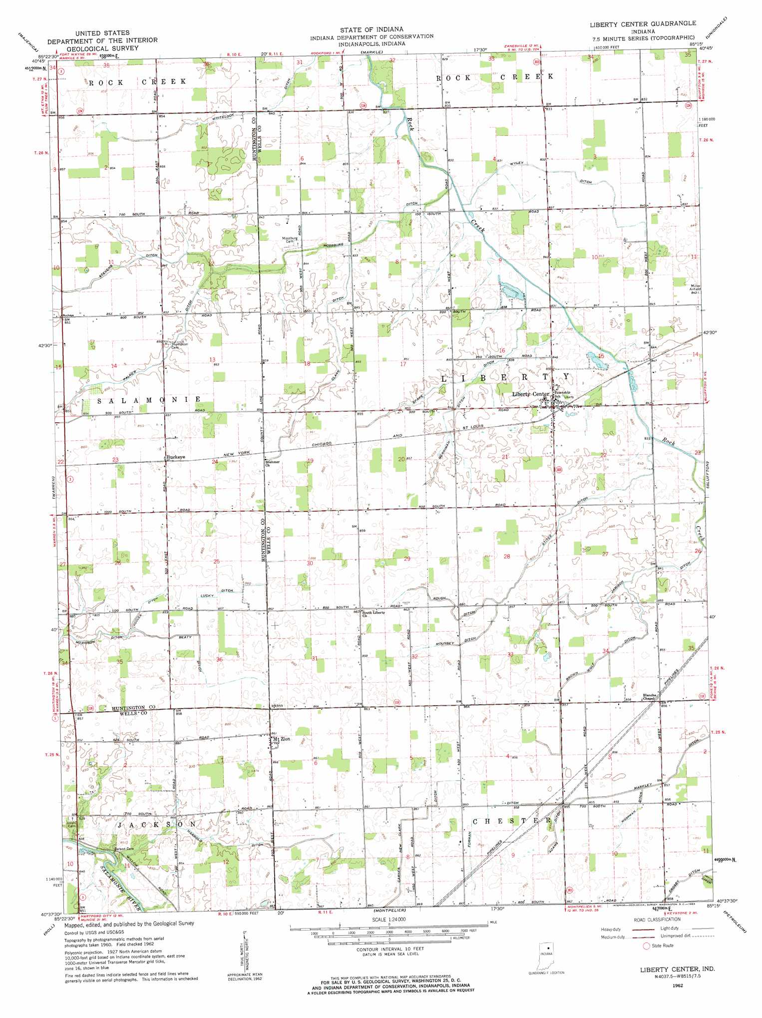
Liberty Center Topo Map Indiana
To zoom in, hover over the map of Liberty Center
USGS Topo Quad 40085f3 - 1:24,000 scale
| Topo Map Name: | Liberty Center |
| USGS Topo Quad ID: | 40085f3 |
| Print Size: | ca. 21 1/4" wide x 27" high |
| Southeast Coordinates: | 40.625° N latitude / 85.25° W longitude |
| Map Center Coordinates: | 40.6875° N latitude / 85.3125° W longitude |
| U.S. State: | IN |
| Filename: | o40085f3.jpg |
| Download Map JPG Image: | Liberty Center topo map 1:24,000 scale |
| Map Type: | Topographic |
| Topo Series: | 7.5´ |
| Map Scale: | 1:24,000 |
| Source of Map Images: | United States Geological Survey (USGS) |
| Alternate Map Versions: |
Liberty Center IN 1962, updated 1963 Download PDF Buy paper map Liberty Center IN 2010 Download PDF Buy paper map Liberty Center IN 2013 Download PDF Buy paper map Liberty Center IN 2016 Download PDF Buy paper map |
1:24,000 Topo Quads surrounding Liberty Center
Bippus |
Huntington |
Zanesville |
Ossian |
Poe |
Andrews |
Majenica |
Markle |
Uniondale |
Preble |
Mount Etna |
Warren |
Liberty Center |
Bluffton |
Linn Grove |
Van Buren |
Roll |
Montpelier |
Petroleum |
Domestic |
Gas City |
Hartford City West |
Hartford City East |
Pennville |
Blaine |
> Back to 40085e1 at 1:100,000 scale
> Back to 40084a1 at 1:250,000 scale
> Back to U.S. Topo Maps home
Liberty Center topo map: Gazetteer
Liberty Center: Canals
Adams Ditch elevation 260m 853′Beaty Ditch elevation 261m 856′
Brown Wolf Ditch elevation 260m 853′
Carnes New Clark Ditch elevation 261m 856′
Clark Ditch elevation 258m 846′
Crosby Ditch elevation 260m 853′
Forman Ditch elevation 261m 856′
Harrold Ditch elevation 257m 843′
Hoover Ditch elevation 261m 856′
Jamison Ditch elevation 257m 843′
Lucky Ditch elevation 261m 856′
Markley Ditch elevation 260m 853′
Merrima Ditch elevation 258m 846′
Moorman Ditch elevation 261m 856′
Mossburg Ditch elevation 253m 830′
Mounsey Ditch elevation 261m 856′
Neff Ditch elevation 253m 830′
Palmer Ditch elevation 258m 846′
Roush Ditch elevation 260m 853′
Spake Ditch elevation 256m 839′
Stevens Ditch elevation 258m 846′
Stites Ditch elevation 257m 843′
Whitelock Ditch elevation 255m 836′
Wyley Ditch elevation 254m 833′
Liberty Center: Populated Places
Buckeye elevation 263m 862′Liberty Center elevation 260m 853′
Mount Zion elevation 263m 862′
Liberty Center digital topo map on disk
Buy this Liberty Center topo map showing relief, roads, GPS coordinates and other geographical features, as a high-resolution digital map file on DVD:
Northern Illinois, Northern Indiana & Southwestern Michigan
Buy digital topo maps: Northern Illinois, Northern Indiana & Southwestern Michigan