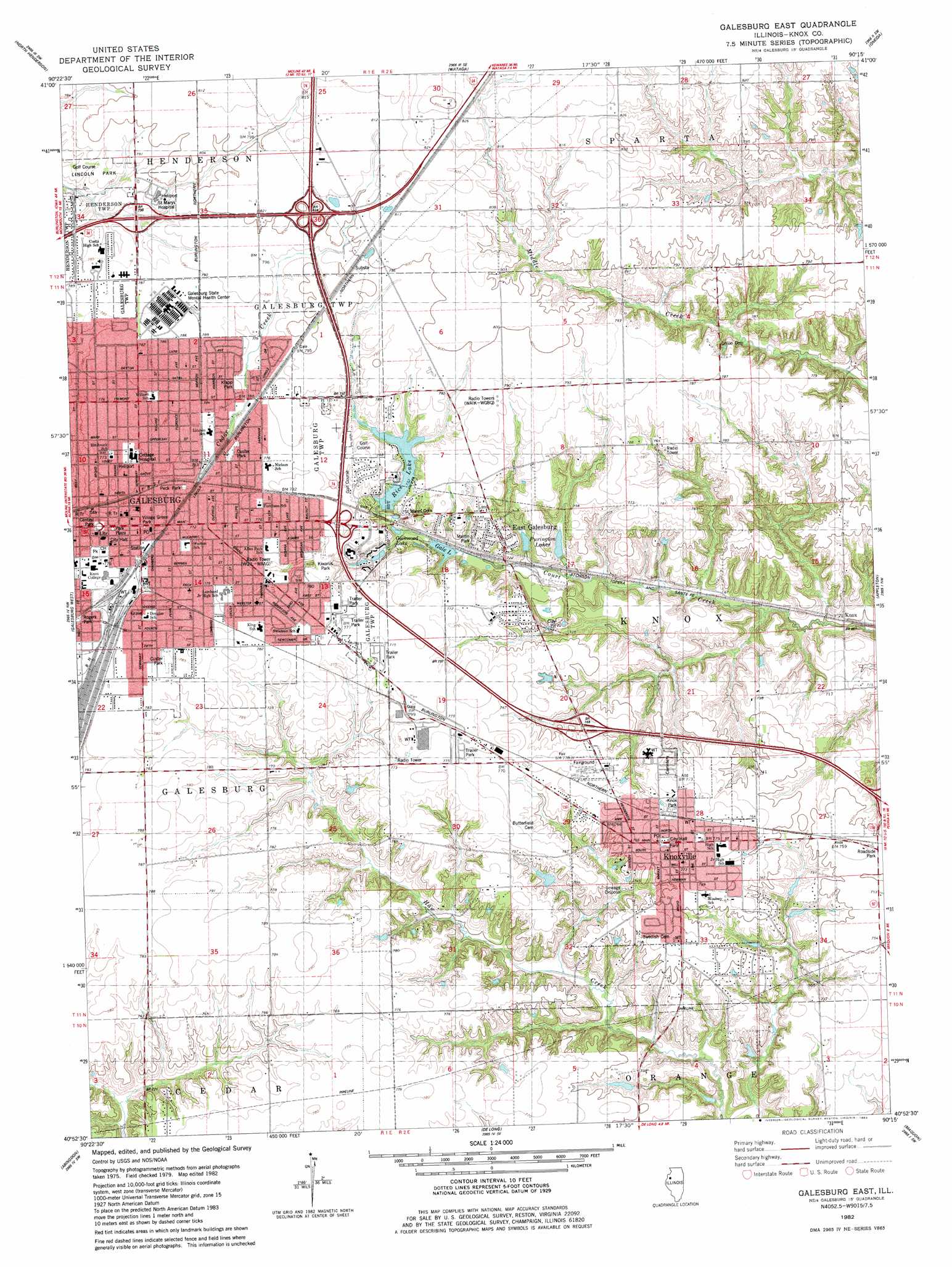
Galesburg East Topo Map Illinois
To zoom in, hover over the map of Galesburg East
USGS Topo Quad 40090h3 - 1:24,000 scale
| Topo Map Name: | Galesburg East |
| USGS Topo Quad ID: | 40090h3 |
| Print Size: | ca. 21 1/4" wide x 27" high |
| Southeast Coordinates: | 40.875° N latitude / 90.25° W longitude |
| Map Center Coordinates: | 40.9375° N latitude / 90.3125° W longitude |
| U.S. State: | IL |
| Filename: | o40090h3.jpg |
| Download Map JPG Image: | Galesburg East topo map 1:24,000 scale |
| Map Type: | Topographic |
| Topo Series: | 7.5´ |
| Map Scale: | 1:24,000 |
| Source of Map Images: | United States Geological Survey (USGS) |
| Alternate Map Versions: |
Galesburg East IL 1982, updated 1983 Download PDF Buy paper map Galesburg East IL 2012 Download PDF Buy paper map Galesburg East IL 2015 Download PDF Buy paper map |
1:24,000 Topo Quads surrounding Galesburg East
Viola |
New Windsor |
Woodhull |
Nekoma |
Galva |
Alexis |
North Henderson |
Wataga |
Oneida |
Victoria |
Cameron |
Galesburg West |
Galesburg East |
Appleton |
Williamsfield |
Berwick |
Abingdon |
De Long |
Maquon |
Yates City |
Greenbush |
Avon |
London Mills |
Fairview |
Farmington West |
> Back to 40090e1 at 1:100,000 scale
> Back to 40090a1 at 1:250,000 scale
> Back to U.S. Topo Maps home
Galesburg East topo map: Gazetteer
Galesburg East: Airports
Galesburg Cottage Hospital Heliport elevation 235m 770′Galesburg East: Crossings
Interchange 46 elevation 248m 813′Interchange 48 elevation 244m 800′
Interchange 51 elevation 230m 754′
Galesburg East: Dams
Lake Rice Dam elevation 229m 751′Galesburg East: Lakes
Glenwood Lake elevation 217m 711′Galesburg East: Parks
Carl Sandburg Birthplace Historic Site elevation 238m 780′Central Park elevation 235m 770′
Custer Park elevation 239m 784′
Custer Park elevation 234m 767′
Galesburg Historic District elevation 234m 767′
Kiwanis Park elevation 236m 774′
Klapp Park elevation 238m 780′
Knox Park elevation 235m 770′
Lincoln Park elevation 235m 770′
Martin Park elevation 230m 754′
Park Plaza elevation 235m 770′
Peck Park elevation 234m 767′
Village Green Park elevation 237m 777′
Galesburg East: Populated Places
East Galesburg elevation 236m 774′Galesburg elevation 235m 770′
Knox elevation 201m 659′
Knoxville elevation 238m 780′
Galesburg East: Post Offices
Center Point Post Office (historical) elevation 243m 797′Galesburg Post Office elevation 238m 780′
Knoxville Post Office elevation 238m 780′
Galesburg East: Reservoirs
Gale Lake elevation 219m 718′Purington Lakes elevation 217m 711′
Rice Lake elevation 229m 751′
Galesburg East digital topo map on disk
Buy this Galesburg East topo map showing relief, roads, GPS coordinates and other geographical features, as a high-resolution digital map file on DVD: