Gould Nw Topo Map Colorado
To zoom in, hover over the map of Gould Nw
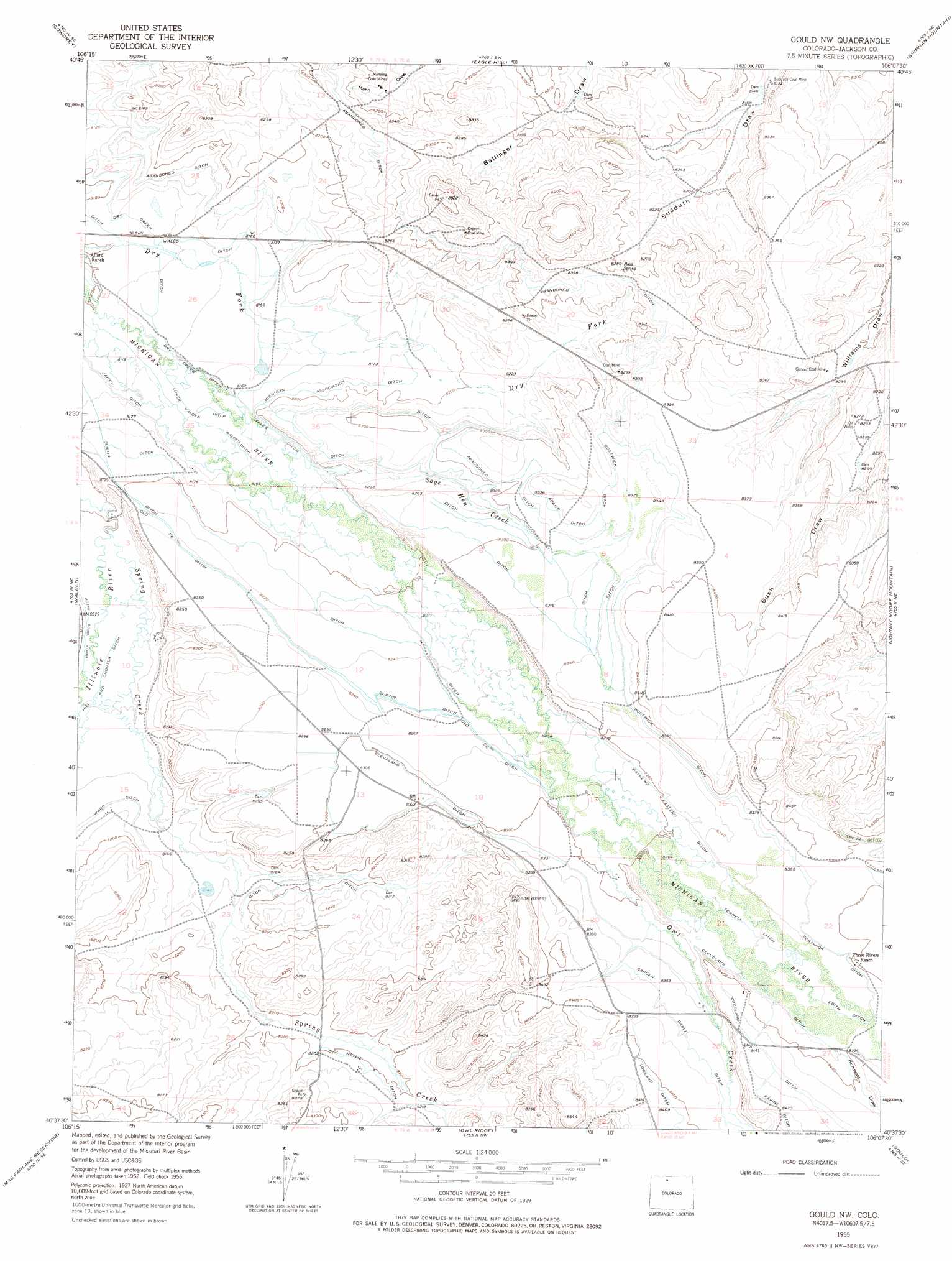
USGS Topo Quad 40106f2 - 1:24,000 scale
| Topo Map Name: | Gould Nw |
| USGS Topo Quad ID: | 40106f2 |
| Print Size: | ca. 21 1/4" wide x 27" high |
| Southeast Coordinates: | 40.625° N latitude / 106.125° W longitude |
| Map Center Coordinates: | 40.6875° N latitude / 106.1875° W longitude |
| U.S. State: | CO |
| Filename: | o40106f2.jpg |
| Download Map JPG Image: | Gould Nw topo map 1:24,000 scale |
| Map Type: | Topographic |
| Topo Series: | 7.5´ |
| Map Scale: | 1:24,000 |
| Source of Map Images: | United States Geological Survey (USGS) |
| Alternate Map Versions: |
Gould NW CO 1955, updated 1957 Download PDF Buy paper map Gould NW CO 1955, updated 1963 Download PDF Buy paper map Gould NW CO 1955, updated 1975 Download PDF Buy paper map Gould NW CO 2010 Download PDF Buy paper map Gould NW CO 2013 Download PDF Buy paper map Gould NW CO 2016 Download PDF Buy paper map |
1:24,000 Topo Quads surrounding Gould Nw
Independence Mountain |
Northgate |
Kings Canyon |
Old Roach |
Crazy Mountain |
Lake John |
Cowdrey |
Eagle Hill |
Shipman Mountain |
Glendevey |
Delaney Butte |
Walden |
Gould Nw |
Johnny Moore Mountain |
Rawah Lakes |
Coalmont |
Macfarlane Reservoir |
Owl Ridge |
Gould |
Clark Peak |
Spicer Peak |
Buffalo Peak |
Rand |
Jack Creek Ranch |
Mount Richthofen |
> Back to 40106e1 at 1:100,000 scale
> Back to 40106a1 at 1:250,000 scale
> Back to U.S. Topo Maps home
Gould Nw topo map: Gazetteer
Gould Nw: Canals
Bostwick Ditch elevation 2552m 8372′Carden Dagle Ditch elevation 2550m 8366′
Cleveland Ditch elevation 2539m 8330′
Curtin Ditch elevation 2518m 8261′
Edith Ditch elevation 2552m 8372′
Hill and Crouter Ditch elevation 2476m 8123′
Jakey Ditch elevation 2482m 8143′
Lower Walden Ditch elevation 2482m 8143′
Mathews Eastern Ditch elevation 2537m 8323′
Michigan Association Ditch elevation 2496m 8188′
Nellie E Ditch elevation 2505m 8218′
Old S C Ditch elevation 2515m 8251′
Walden Ditch elevation 2487m 8159′
Wales Ditch elevation 2489m 8166′
Gould Nw: Mines
Capron Mine elevation 2535m 8316′Conrad Coal Mine elevation 2517m 8257′
Manning Coal Mines elevation 2488m 8162′
Monolith Mine elevation 2569m 8428′
Sudduth Coal Mine elevation 2481m 8139′
Gould Nw: Streams
Dry Fork Michigan River elevation 2528m 8293′Meadow Creek elevation 2557m 8389′
Owl Creek elevation 2525m 8284′
Sage Hen Creek elevation 2494m 8182′
Spring Creek elevation 2471m 8106′
Gould Nw: Valleys
Ballinger Draw elevation 2532m 8307′Kimmons Draw elevation 2556m 8385′
Gould Nw digital topo map on disk
Buy this Gould Nw topo map showing relief, roads, GPS coordinates and other geographical features, as a high-resolution digital map file on DVD: