Squaw Valley Peak Topo Map California
To zoom in, hover over the map of Squaw Valley Peak
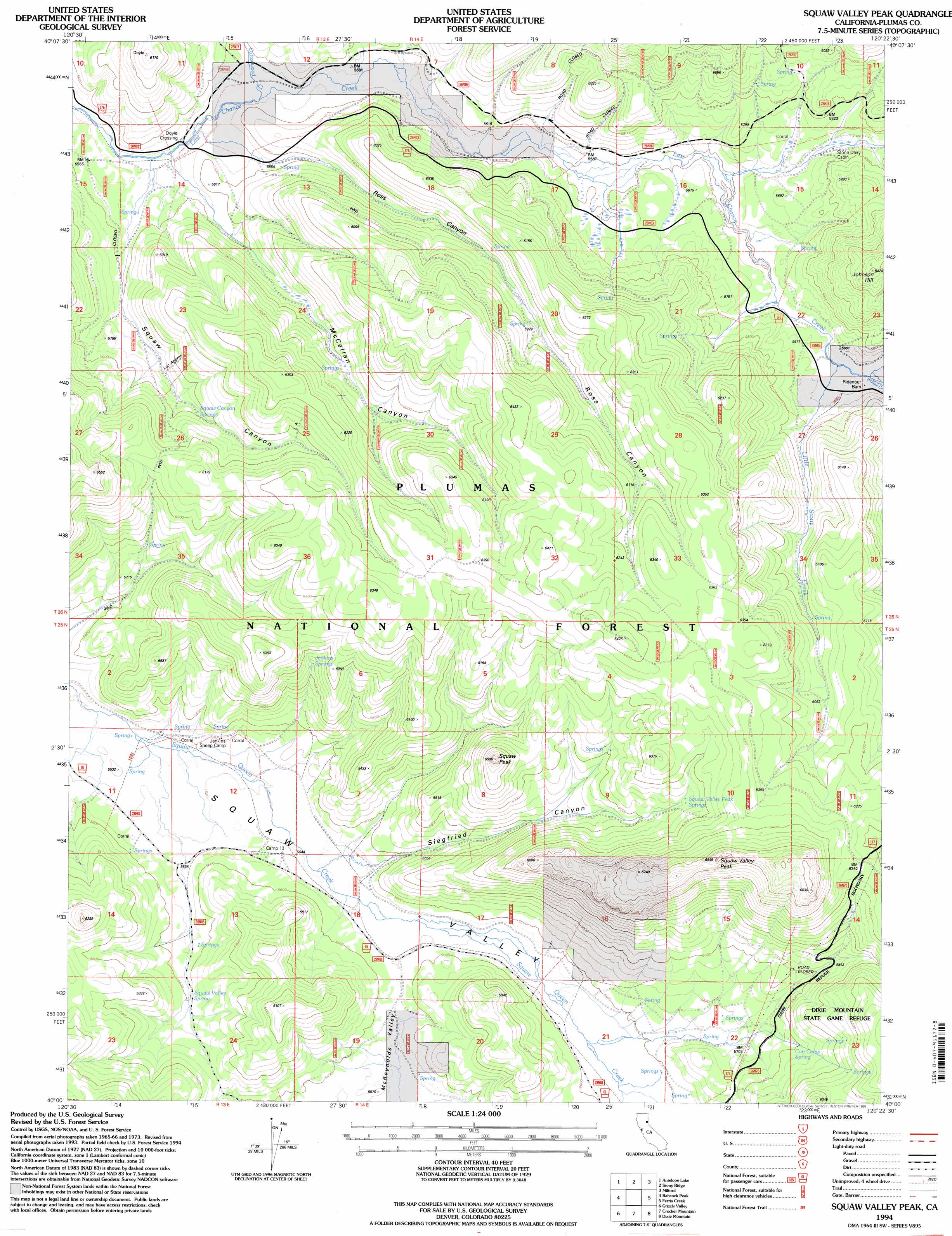
USGS Topo Quad 40120a4 - 1:24,000 scale
| Topo Map Name: | Squaw Valley Peak |
| USGS Topo Quad ID: | 40120a4 |
| Print Size: | ca. 21 1/4" wide x 27" high |
| Southeast Coordinates: | 40° N latitude / 120.375° W longitude |
| Map Center Coordinates: | 40.0625° N latitude / 120.4375° W longitude |
| U.S. State: | CA |
| Filename: | o40120a4.jpg |
| Download Map JPG Image: | Squaw Valley Peak topo map 1:24,000 scale |
| Map Type: | Topographic |
| Topo Series: | 7.5´ |
| Map Scale: | 1:24,000 |
| Source of Map Images: | United States Geological Survey (USGS) |
| Alternate Map Versions: |
Squaw Valley Peak CA 1977, updated 1978 Download PDF Buy paper map Squaw Valley Peak CA 1994, updated 1998 Download PDF Buy paper map Squaw Valley Peak CA 1994, updated 1998 Download PDF Buy paper map Ross Canyon CA 2012 Download PDF Buy paper map Ross Canyon CA 2015 Download PDF Buy paper map |
| FStopo: | US Forest Service topo Squaw Valley Peak is available: Download FStopo PDF Download FStopo TIF |
1:24,000 Topo Quads surrounding Squaw Valley Peak
Diamond Mountain |
Janesville |
Standish |
Wendel Hot Springs |
Wendel |
Kettle Rock |
Antelope Lake |
Stony Ridge |
Milford |
Herlong |
Genesee Valley |
Babcock Peak |
Squaw Valley Peak |
Ferris Creek |
Mckesick Peak |
Mount Ingalls |
Grizzly Valley |
Crocker Mountain |
Dixie Mountain |
Frenchman Lake |
Johnsville |
Blairsden |
Portola |
Reconnaissance Peak |
Chilcoot |
> Back to 40120a1 at 1:100,000 scale
> Back to 40120a1 at 1:250,000 scale
> Back to U.S. Topo Maps home
Squaw Valley Peak topo map: Gazetteer
Squaw Valley Peak: Crossings
Doyle Crossing elevation 1682m 5518′Squaw Valley Peak: Springs
Cow Camp Spring elevation 1771m 5810′Jenkins Springs elevation 1785m 5856′
Squaw Valley Peak Springs elevation 1862m 6108′
Squaw Valley Spring elevation 1708m 5603′
Squaw Valley Peak: Streams
Cottonwood Creek elevation 1694m 5557′Little Stony Creek elevation 1721m 5646′
Rogers Creek elevation 1681m 5515′
Willow Creek elevation 1724m 5656′
Squaw Valley Peak: Summits
Squaw Peak elevation 1976m 6482′Squaw Valley Peak elevation 2078m 6817′
Squaw Valley Peak: Valleys
McClellan Canyon elevation 1686m 5531′Ross Canyon elevation 1689m 5541′
Siegfried Canyon elevation 1695m 5561′
Squaw Canyon elevation 1686m 5531′
Squaw Valley Peak digital topo map on disk
Buy this Squaw Valley Peak topo map showing relief, roads, GPS coordinates and other geographical features, as a high-resolution digital map file on DVD: