Frenchman Lake Topo Map California
To zoom in, hover over the map of Frenchman Lake
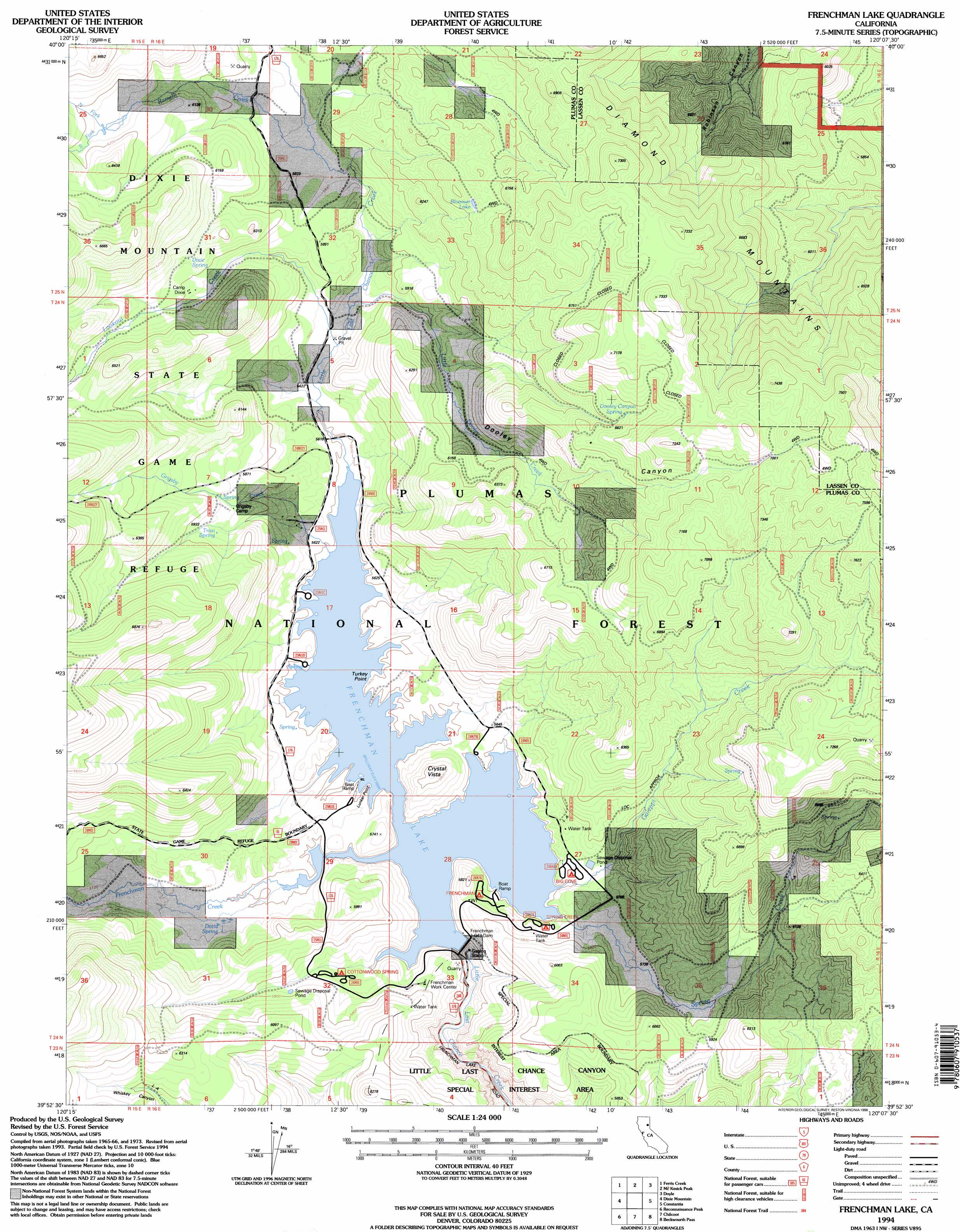
USGS Topo Quad 39120h2 - 1:24,000 scale
| Topo Map Name: | Frenchman Lake |
| USGS Topo Quad ID: | 39120h2 |
| Print Size: | ca. 21 1/4" wide x 27" high |
| Southeast Coordinates: | 39.875° N latitude / 120.125° W longitude |
| Map Center Coordinates: | 39.9375° N latitude / 120.1875° W longitude |
| U.S. State: | CA |
| Filename: | o39120h2.jpg |
| Download Map JPG Image: | Frenchman Lake topo map 1:24,000 scale |
| Map Type: | Topographic |
| Topo Series: | 7.5´ |
| Map Scale: | 1:24,000 |
| Source of Map Images: | United States Geological Survey (USGS) |
| Alternate Map Versions: |
Frenchman Lake CA 1979, updated 1979 Download PDF Buy paper map Frenchman Lake CA 1994, updated 1998 Download PDF Buy paper map Frenchman Lake CA 1994, updated 1998 Download PDF Buy paper map Frenchman Lake CA 2012 Download PDF Buy paper map Frenchman Lake CA 2015 Download PDF Buy paper map |
| FStopo: | US Forest Service topo Frenchman Lake is available: Download FStopo PDF Download FStopo TIF |
1:24,000 Topo Quads surrounding Frenchman Lake
Stony Ridge |
Milford |
Herlong |
Calneva |
Flanigan |
Squaw Valley Peak |
Ferris Creek |
Mckesick Peak |
Doyle |
State Line Peak |
Crocker Mountain |
Dixie Mountain |
Frenchman Lake |
Constantia |
|
Portola |
Reconnaissance Peak |
Chilcoot |
Beckwourth Pass |
Granite Peak |
Calpine |
Antelope Valley |
Loyalton |
Evans Canyon |
Reno Nw |
> Back to 39120e1 at 1:100,000 scale
> Back to 39120a1 at 1:250,000 scale
> Back to U.S. Topo Maps home
Frenchman Lake topo map: Gazetteer
Frenchman Lake: Capes
Lunker Point elevation 1706m 5597′Turkey Point elevation 1710m 5610′
Frenchman Lake: Dams
Frenchman 1-043 Dam elevation 1700m 5577′Frenchman Dam elevation 1707m 5600′
Frenchman Lake: Flats
Last Chance Valley (historical) elevation 1704m 5590′Frenchman Lake: Lakes
Bloomer Lake elevation 1973m 6473′Frenchman Lake: Parks
Little Last Chance Canyon Scenic Area elevation 1660m 5446′Frenchman Lake: Reservoirs
Frenchman Lake elevation 1707m 5600′Frenchman Lake: Springs
Dixie Spring elevation 1848m 6062′Dooley Canyon Spring elevation 2031m 6663′
Dotta Spring elevation 1721m 5646′
Grigsby Spring elevation 1802m 5912′
Trosi Spring elevation 1798m 5898′
Frenchman Lake: Streams
Frenchman Creek elevation 1704m 5590′Galeppi Creek elevation 1705m 5593′
Grigsby Creek elevation 1705m 5593′
Little Dooley Creek elevation 1724m 5656′
Lookout Creek elevation 1724m 5656′
North Fork Ramelli Creek elevation 1874m 6148′
Ramelli Creek elevation 1785m 5856′
South Fork Ramelli Creek elevation 1873m 6145′
Spring Creek elevation 1706m 5597′
Frenchman Lake: Valleys
Dooley Canyon elevation 1742m 5715′Frenchman Lake digital topo map on disk
Buy this Frenchman Lake topo map showing relief, roads, GPS coordinates and other geographical features, as a high-resolution digital map file on DVD: