Newtown Topo Map Connecticut
To zoom in, hover over the map of Newtown
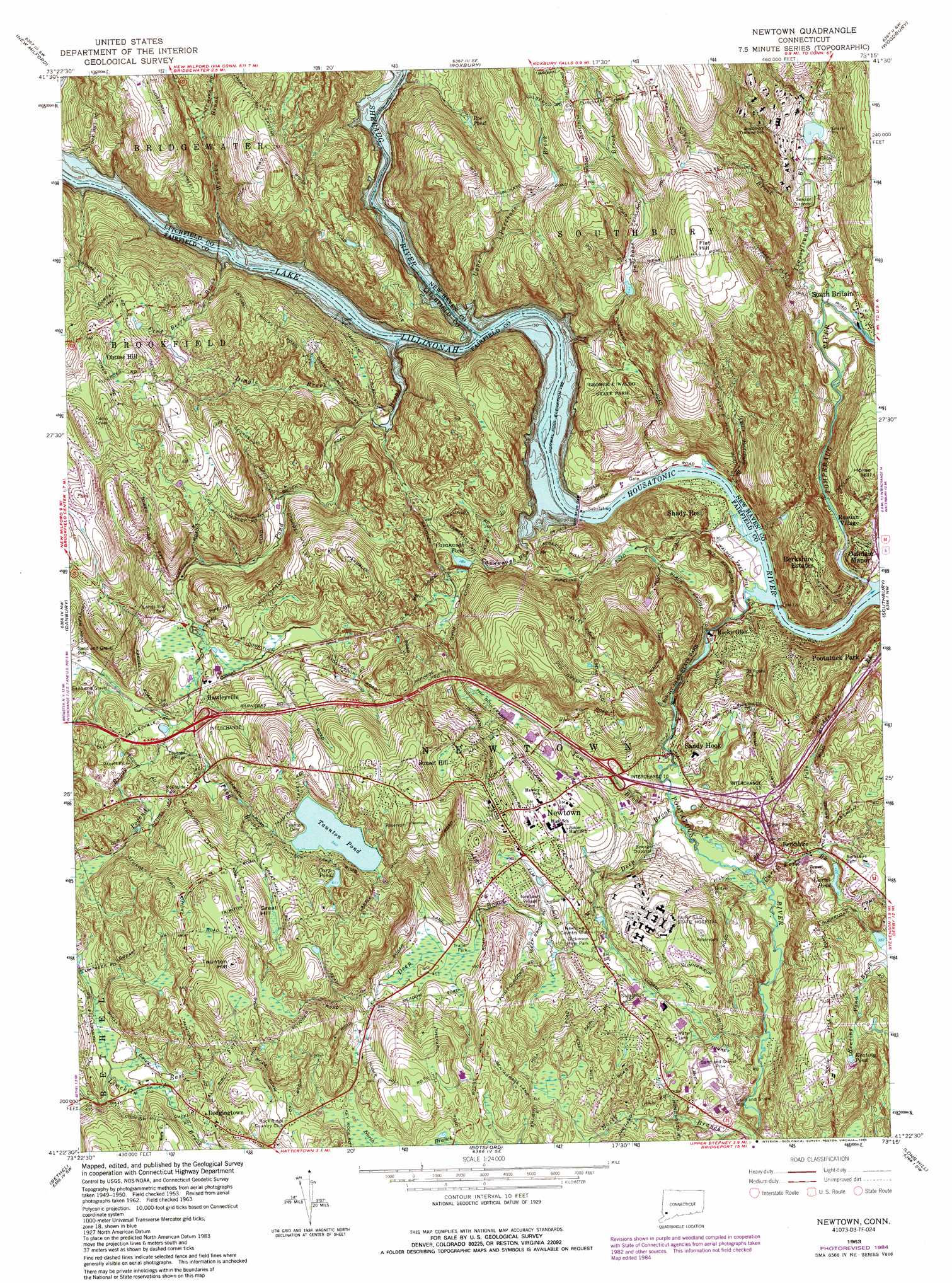
USGS Topo Quad 41073d3 - 1:24,000 scale
| Topo Map Name: | Newtown |
| USGS Topo Quad ID: | 41073d3 |
| Print Size: | ca. 21 1/4" wide x 27" high |
| Southeast Coordinates: | 41.375° N latitude / 73.25° W longitude |
| Map Center Coordinates: | 41.4375° N latitude / 73.3125° W longitude |
| U.S. State: | CT |
| Filename: | o41073d3.jpg |
| Download Map JPG Image: | Newtown topo map 1:24,000 scale |
| Map Type: | Topographic |
| Topo Series: | 7.5´ |
| Map Scale: | 1:24,000 |
| Source of Map Images: | United States Geological Survey (USGS) |
| Alternate Map Versions: |
Newtown CT 1953, updated 1959 Download PDF Buy paper map Newtown CT 1963, updated 1965 Download PDF Buy paper map Newtown CT 1963, updated 1974 Download PDF Buy paper map Newtown CT 1963, updated 1985 Download PDF Buy paper map Newtown CT 1963, updated 1985 Download PDF Buy paper map Newtown CT 2012 Download PDF Buy paper map Newtown CT 2015 Download PDF Buy paper map |
1:24,000 Topo Quads surrounding Newtown
Dover Plains |
Kent |
New Preston |
Litchfield |
Thomaston |
Pawling |
New Milford |
Roxbury |
Woodbury |
Waterbury |
Brewster |
Danbury |
Newtown |
Southbury |
Naugatuck |
Peach Lake |
Bethel |
Botsford |
Long Hill |
Ansonia |
Pound Ridge |
Norwalk North |
Westport |
Bridgeport |
Milford |
> Back to 41073a1 at 1:100,000 scale
> Back to 41072a1 at 1:250,000 scale
> Back to U.S. Topo Maps home
Newtown topo map: Gazetteer
Newtown: Bridges
Stanley Simon Bridge elevation 116m 380′Newtown: Crossings
Interchange 10 elevation 101m 331′Interchange 11 elevation 108m 354′
Interchange 9 elevation 122m 400′
Newtown: Dams
Curtis Pond Dam elevation 108m 354′Gravel Pond Dam elevation 52m 170′
Rocky Glen Dam elevation 67m 219′
Sandy Hook Dam elevation 75m 246′
Shedpaug Dam elevation 60m 196′
Sheraug Dam elevation 56m 183′
Taunton Pond Dam elevation 165m 541′
Walnut Hill Pond Dam elevation 108m 354′
Wellgoto Pond Dam elevation 118m 387′
Wewaka Brook Pond Dam elevation 121m 396′
Newtown: Lakes
Carp Pond elevation 186m 610′Cavanaugh Pond elevation 87m 285′
Keating Pond elevation 157m 515′
Roe Pond elevation 111m 364′
Taunton Pond elevation 165m 541′
Newtown: Parks
Bend of the River Sanctuary elevation 73m 239′Dickinson Memorial Park elevation 126m 413′
George C Waldo State Park elevation 98m 321′
Rocky Glen State Park elevation 110m 360′
Russian Village Historic District elevation 95m 311′
South Britain Historic District elevation 44m 144′
Town Park elevation 66m 216′
Treadwell Memorial Park elevation 105m 344′
Newtown: Populated Places
Berkshire elevation 102m 334′Berkshire Estates elevation 99m 324′
Dodgingtown elevation 156m 511′
Hawleyville elevation 110m 360′
Morgan Fair Corners elevation 135m 442′
Newtown elevation 145m 475′
Oakdale Manor elevation 48m 157′
Obtuse Hill elevation 182m 597′
Pootatuck Park elevation 133m 436′
Rocky Glen elevation 72m 236′
Russian Village elevation 69m 226′
Sandy Hook elevation 79m 259′
Shady Rest elevation 43m 141′
South Britain elevation 47m 154′
Newtown: Post Offices
Sandy Hook Post Office elevation 85m 278′Newtown: Reservoirs
Curtis Pond elevation 108m 354′Gravel Pond elevation 52m 170′
Lake Lillinonah elevation 56m 183′
Pootatuck River Reservoir elevation 67m 219′
Walnut Hill Pond elevation 108m 354′
Wellgoto Pond elevation 118m 387′
Wewaka Brook Pond elevation 121m 396′
Newtown: Streams
Cavanaugh Brook elevation 60m 196′Cold Spring Brook elevation 115m 377′
Curtis Pond Brook elevation 79m 259′
Deep Brook elevation 72m 236′
Dingle Brook elevation 65m 213′
East Fork elevation 133m 436′
Fred Beers Brook elevation 65m 213′
Keating Pond Brook elevation 108m 354′
Little Pootatuck Brook elevation 32m 104′
North Branch Pootatuck River elevation 148m 485′
Pogond Brook elevation 104m 341′
Pomperaug River elevation 32m 104′
Pond Brook elevation 60m 196′
Pootatuck River elevation 32m 104′
Purchase Brook elevation 76m 249′
Shepaug River elevation 60m 196′
Spruce Brook elevation 48m 157′
Tom Brook elevation 71m 232′
Transylvania Brook elevation 39m 127′
Upper Purchase Brook elevation 68m 223′
Wewaka Brook elevation 89m 291′
Newtown: Summits
Barnabas Hill elevation 200m 656′Cedar Hill elevation 185m 606′
Flat Hill elevation 213m 698′
Great Hill elevation 217m 711′
Horse Hill elevation 131m 429′
Mount Pleasant elevation 230m 754′
Sugar Hill elevation 213m 698′
Sugarloaf elevation 137m 449′
Sunset Hill elevation 188m 616′
Taunton Hill elevation 251m 823′
Newtown digital topo map on disk
Buy this Newtown topo map showing relief, roads, GPS coordinates and other geographical features, as a high-resolution digital map file on DVD:
New York, Vermont, Connecticut & Western Massachusetts
Buy digital topo maps: New York, Vermont, Connecticut & Western Massachusetts