Sylvania Topo Map Ohio
To zoom in, hover over the map of Sylvania
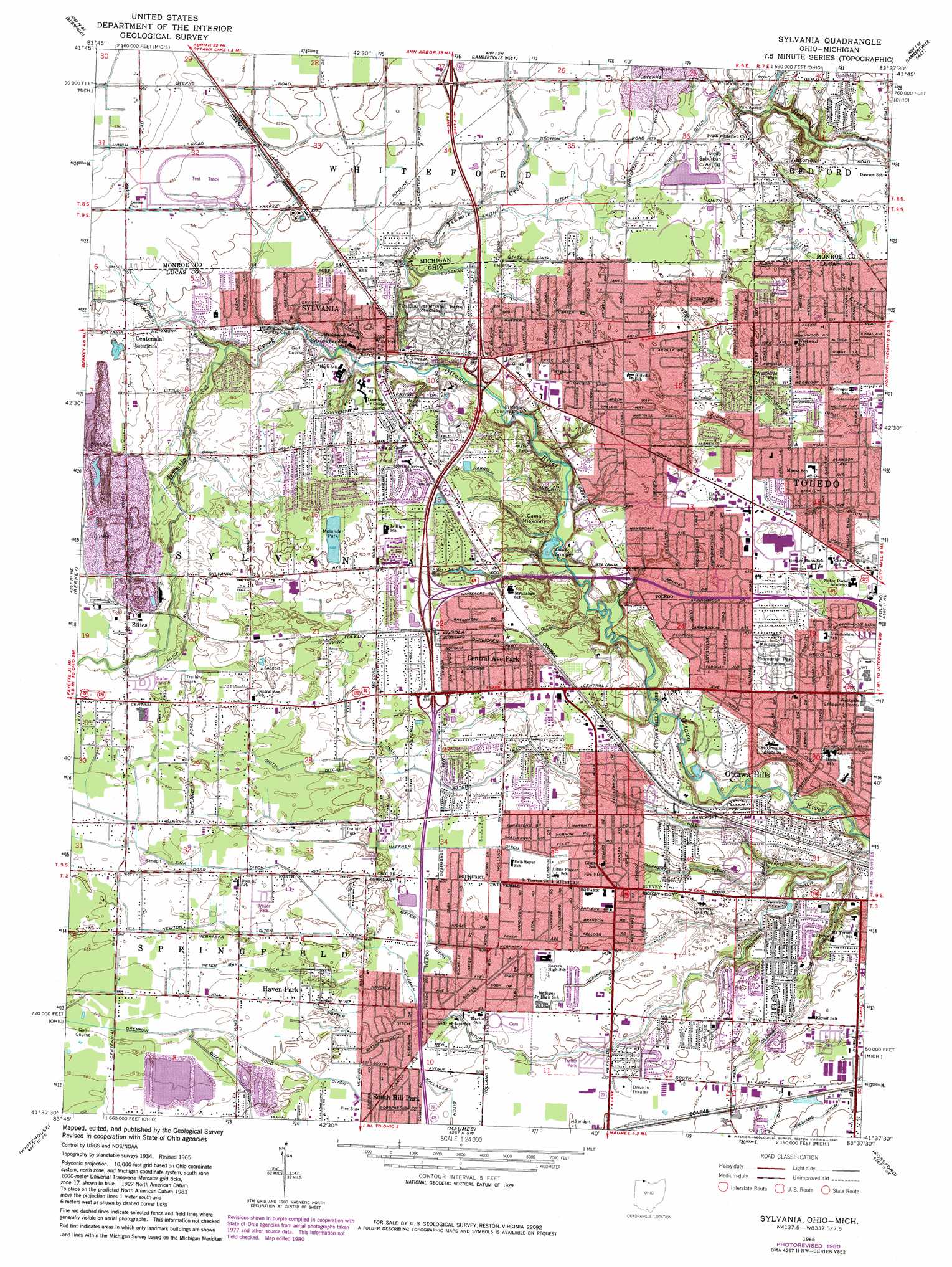
USGS Topo Quad 41083f6 - 1:24,000 scale
| Topo Map Name: | Sylvania |
| USGS Topo Quad ID: | 41083f6 |
| Print Size: | ca. 21 1/4" wide x 27" high |
| Southeast Coordinates: | 41.625° N latitude / 83.625° W longitude |
| Map Center Coordinates: | 41.6875° N latitude / 83.6875° W longitude |
| U.S. States: | OH, MI |
| Filename: | o41083f6.jpg |
| Download Map JPG Image: | Sylvania topo map 1:24,000 scale |
| Map Type: | Topographic |
| Topo Series: | 7.5´ |
| Map Scale: | 1:24,000 |
| Source of Map Images: | United States Geological Survey (USGS) |
| Alternate Map Versions: |
Sylvania OH 1951, updated 1952 Download PDF Buy paper map Sylvania OH 1951, updated 1952 Download PDF Buy paper map Sylvania OH 1965, updated 1967 Download PDF Buy paper map Sylvania OH 1965, updated 1977 Download PDF Buy paper map Sylvania OH 1965, updated 1980 Download PDF Buy paper map Sylvania OH 2011 Download PDF Buy paper map Sylvania OH 2013 Download PDF Buy paper map Sylvania OH 2016 Download PDF Buy paper map |
1:24,000 Topo Quads surrounding Sylvania
Tecumseh South |
Deerfield |
Dundee |
Ida |
Monroe |
Palmyra |
Blissfield |
Lambertville West |
Lambertville East |
Erie |
Assumption |
Berkey |
Sylvania |
Toledo |
Oregon |
Swanton |
Whitehouse |
Maumee |
Rossford |
Walbridge |
Colton |
Grand Rapids |
Bowling Green North |
Dunbridge |
Pemberville |
> Back to 41083e1 at 1:100,000 scale
> Back to 41082a1 at 1:250,000 scale
> Back to U.S. Topo Maps home
Sylvania topo map: Gazetteer
Sylvania: Airports
Dana Heliport elevation 190m 623′Flower Memorial Hospital Heliport elevation 196m 643′
Toledo Suburban Airport elevation 204m 669′
Sylvania: Canals
Deline Ditch elevation 186m 610′Dennis Ditch elevation 185m 606′
Eggeman Ditch elevation 203m 666′
Eisenbraum Ditch elevation 193m 633′
Good Ditch elevation 193m 633′
Haefner Ditch elevation 192m 629′
Harroun Ditch elevation 196m 643′
Heath Ditch elevation 201m 659′
Heldman Ditch elevation 186m 610′
Kallager Ditch elevation 192m 629′
Kitzman Ditch elevation 193m 633′
Kubitz Ditch elevation 201m 659′
Mayer Ditch elevation 193m 633′
Newton Ditch elevation 200m 656′
Peter May Ditch elevation 200m 656′
Potter Ditch elevation 193m 633′
Schlicker Ditch elevation 198m 649′
Schreiber Ditch elevation 202m 662′
Smith Ditch elevation 201m 659′
Smith Ditch elevation 200m 656′
Wahl Ditch elevation 189m 620′
Zink Ditch elevation 199m 652′
Sylvania: Crossings
Interchange 1 elevation 206m 675′Interchange 13 elevation 200m 656′
Interchange 14 elevation 201m 659′
Interchange 15 elevation 193m 633′
Interchange 15 elevation 192m 629′
Interchange 16 elevation 193m 633′
Sylvania: Lakes
Lake Sawyer elevation 184m 603′Sylvania: Mines
Sylvania Quarry elevation 198m 649′Sylvania: Parks
Molander Park elevation 204m 669′Nona Frances Centennial Park elevation 205m 672′
Rogers Park elevation 191m 626′
Westwood Park elevation 194m 636′
Wildwood Preserve Metropark elevation 195m 639′
Winterfield Park elevation 190m 623′
Sylvania: Populated Places
Centennial elevation 205m 672′Central Avenue Park elevation 197m 646′
Elden Heights elevation 205m 672′
Haven Park elevation 199m 652′
Hidden Creek Manufactured Home Community elevation 204m 669′
Ottawa Hills elevation 184m 603′
Reynolds Corners elevation 191m 626′
Richards (historical) elevation 191m 626′
Silica elevation 203m 666′
South Hill Park elevation 193m 633′
Sylvania elevation 202m 662′
Sylvania: Post Offices
Reynolds Corners Post Office (historical) elevation 191m 626′Richards Post Office (historical) elevation 190m 623′
Silica Post Office (historical) elevation 203m 666′
Sylvania Post Office elevation 201m 659′
Sylvania: Streams
North Tenmile Creek elevation 189m 620′North Tenmile Creek elevation 189m 620′
Tenmile Creek elevation 189m 620′
Sylvania digital topo map on disk
Buy this Sylvania topo map showing relief, roads, GPS coordinates and other geographical features, as a high-resolution digital map file on DVD:
 map DVD")