Rochelle Topo Map Illinois
To zoom in, hover over the map of Rochelle
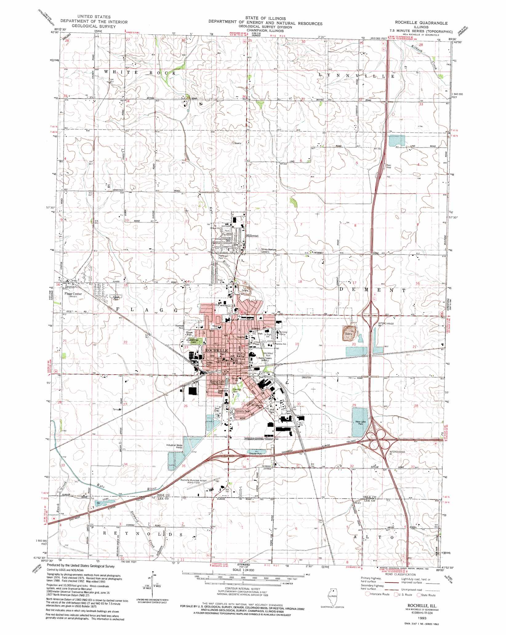
USGS Topo Quad 41089h1 - 1:24,000 scale
| Topo Map Name: | Rochelle |
| USGS Topo Quad ID: | 41089h1 |
| Print Size: | ca. 21 1/4" wide x 27" high |
| Southeast Coordinates: | 41.875° N latitude / 89° W longitude |
| Map Center Coordinates: | 41.9375° N latitude / 89.0625° W longitude |
| U.S. State: | IL |
| Filename: | o41089h1.jpg |
| Download Map JPG Image: | Rochelle topo map 1:24,000 scale |
| Map Type: | Topographic |
| Topo Series: | 7.5´ |
| Map Scale: | 1:24,000 |
| Source of Map Images: | United States Geological Survey (USGS) |
| Alternate Map Versions: |
Rochelle IL 1975, updated 1978 Download PDF Buy paper map Rochelle IL 1993, updated 1993 Download PDF Buy paper map Rochelle IL 2012 Download PDF Buy paper map Rochelle IL 2015 Download PDF Buy paper map |
1:24,000 Topo Quads surrounding Rochelle
Seward |
Kishwaukee |
Rockford South |
Cherry Valley |
Belvidere South |
Oregon |
Stillman Valley |
Kings |
Fairdale |
Kirkland |
Daysville |
Chana |
Rochelle |
Creston |
De Kalb |
Franklin Grove |
Ashton |
Steward |
Lee |
Waterman |
Amboy |
Sublette |
Compton |
Paw Paw |
Shabbona Grove |
> Back to 41089e1 at 1:100,000 scale
> Back to 41088a1 at 1:250,000 scale
> Back to U.S. Topo Maps home
Rochelle topo map: Gazetteer
Rochelle: Airports
Rochelle Emergency Landing Heliport elevation 241m 790′Rochelle Municipal Airport elevation 236m 774′
Rochelle: Crossings
Interchange 97 elevation 246m 807′Interchange 99 elevation 243m 797′
Rochelle: Lakes
Spring Lake elevation 237m 777′Rochelle: Mines
Macklin Quarry elevation 221m 725′O'Neill Quarry elevation 232m 761′
Rochelle: Parks
Atwood Park elevation 242m 793′Central Park elevation 250m 820′
Connolly Park elevation 237m 777′
Cooper Park elevation 246m 807′
Drexler Park elevation 235m 770′
Flannigan Park elevation 242m 793′
Helms Park and Athletic Complex elevation 248m 813′
Kelley Park elevation 244m 800′
Marina Park elevation 237m 777′
Memorial Park elevation 241m 790′
Mid-West Park elevation 238m 780′
New Lake Park elevation 240m 787′
Powers Park elevation 249m 816′
Sweeney Park elevation 237m 777′
Tilton Park elevation 239m 784′
V F W Park elevation 244m 800′
Rochelle: Populated Places
Askvig Addition elevation 246m 807′Briarwood elevation 249m 816′
Flagg Center elevation 252m 826′
Highland Estates elevation 247m 810′
Hillcrest elevation 253m 830′
Ramsey Acres elevation 252m 826′
Rochelle elevation 251m 823′
Rolling Greens Mobile Home Park elevation 244m 800′
Southgate elevation 241m 790′
Rochelle: Post Offices
Rochelle Post Office elevation 246m 807′Rochelle: Reservoirs
Lake Lida elevation 235m 770′Lake Sule elevation 241m 790′
Rochelle: Streams
Beach Creek elevation 235m 770′Steward Creek elevation 235m 770′
Rochelle digital topo map on disk
Buy this Rochelle topo map showing relief, roads, GPS coordinates and other geographical features, as a high-resolution digital map file on DVD:
Northern Illinois, Northern Indiana & Southwestern Michigan
Buy digital topo maps: Northern Illinois, Northern Indiana & Southwestern Michigan