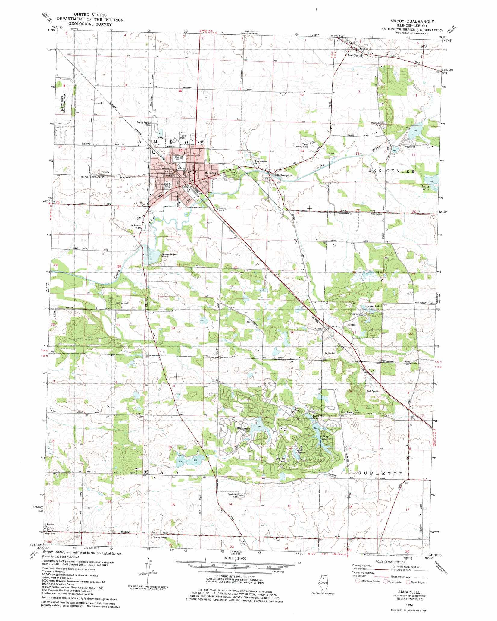
Amboy Topo Map Illinois
To zoom in, hover over the map of Amboy
USGS Topo Quad 41089f3 - 1:24,000 scale
| Topo Map Name: | Amboy |
| USGS Topo Quad ID: | 41089f3 |
| Print Size: | ca. 21 1/4" wide x 27" high |
| Southeast Coordinates: | 41.625° N latitude / 89.25° W longitude |
| Map Center Coordinates: | 41.6875° N latitude / 89.3125° W longitude |
| U.S. State: | IL |
| Filename: | o41089f3.jpg |
| Download Map JPG Image: | Amboy topo map 1:24,000 scale |
| Map Type: | Topographic |
| Topo Series: | 7.5´ |
| Map Scale: | 1:24,000 |
| Source of Map Images: | United States Geological Survey (USGS) |
| Alternate Map Versions: |
Amboy IL 1982, updated 1983 Download PDF Buy paper map Amboy IL 2012 Download PDF Buy paper map Amboy IL 2015 Download PDF Buy paper map |
1:24,000 Topo Quads surrounding Amboy
Polo |
Grand Detour |
Daysville |
Chana |
Rochelle |
Dixon West |
Dixon East |
Franklin Grove |
Ashton |
Steward |
Harmon |
Walton |
Amboy |
Sublette |
Compton |
Walnut |
Ohio |
Lamoille |
Mendota West |
Mendota East |
Buoane |
Princeton North |
Malden |
Ladd |
Troy Grove |
> Back to 41089e1 at 1:100,000 scale
> Back to 41088a1 at 1:250,000 scale
> Back to U.S. Topo Maps home
Amboy topo map: Gazetteer
Amboy: Airports
Leffelman Airport elevation 284m 931′Taylor Airport elevation 233m 764′
Amboy: Dams
Bass Lake Dam elevation 265m 869′Woodhaven Lake Dam elevation 268m 879′
Amboy: Lakes
Lake Sunset elevation 273m 895′Leake Lake elevation 232m 761′
Lyon Lakes elevation 256m 839′
Mallard Pond elevation 282m 925′
Amboy: Mines
Amboy Quarry elevation 228m 748′Amboy: Populated Places
Amboy elevation 227m 744′Binghampton elevation 229m 751′
Lee Center elevation 242m 793′
Maytown elevation 267m 875′
Shelburn (historical) elevation 223m 731′
Amboy: Post Offices
Amboy Post Office elevation 228m 748′Lee Center Post Office elevation 241m 790′
Amboy: Reservoirs
Bass Lake elevation 265m 869′Black Oak Lake elevation 260m 853′
Woodhaven Lake elevation 268m 879′
Amboy: Woods
Inlet Grove elevation 238m 780′Amboy digital topo map on disk
Buy this Amboy topo map showing relief, roads, GPS coordinates and other geographical features, as a high-resolution digital map file on DVD:
Northern Illinois, Northern Indiana & Southwestern Michigan
Buy digital topo maps: Northern Illinois, Northern Indiana & Southwestern Michigan