Lake Alice Topo Map Nebraska
To zoom in, hover over the map of Lake Alice
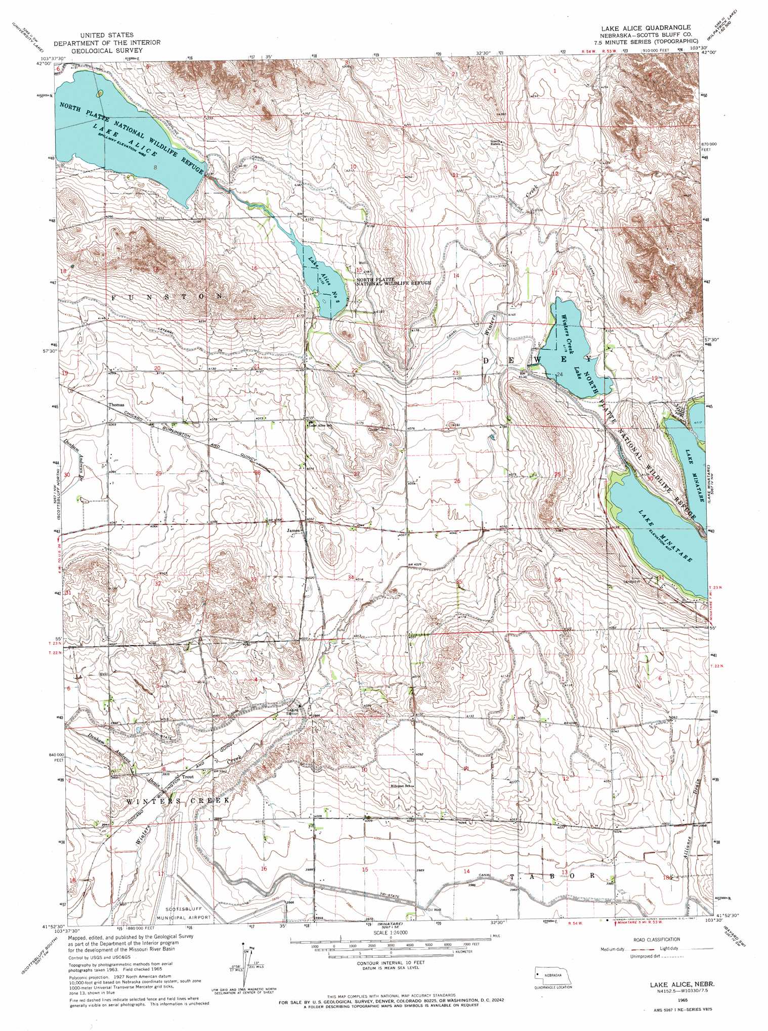
USGS Topo Quad 41103h5 - 1:24,000 scale
| Topo Map Name: | Lake Alice |
| USGS Topo Quad ID: | 41103h5 |
| Print Size: | ca. 21 1/4" wide x 27" high |
| Southeast Coordinates: | 41.875° N latitude / 103.5° W longitude |
| Map Center Coordinates: | 41.9375° N latitude / 103.5625° W longitude |
| U.S. State: | NE |
| Filename: | O41103H5.jpg |
| Download Map JPG Image: | Lake Alice topo map 1:24,000 scale |
| Map Type: | Topographic |
| Topo Series: | 7.5´ |
| Map Scale: | 1:24,000 |
| Source of Map Images: | United States Geological Survey (USGS) |
| Alternate Map Versions: |
Lake Alice NE 1965, updated 1967 Download PDF Buy paper map Lake Alice NE 2011 Download PDF Buy paper map Lake Alice NE 2014 Download PDF Buy paper map |
1:24,000 Topo Quads surrounding Lake Alice
Chalk Buttes Ne |
University Lake Nw |
University Lake Ne |
Kilpatrick Lake Nw |
Kilpatrick Lake Ne |
Erdman Ranch |
University Lake |
University Lake Se |
Kilpatrick Lake Sw |
Kilpatrick Lake |
Mitchell |
Scottsbluff North |
Lake Alice |
Lake Minatare |
Bayard Ne |
Roubadeau Pass |
Scottsbluff South |
Minatare |
Bayard Sw |
Bayard |
Murray Lake Ne |
Wildcat Mountain |
Wright Gap |
Mcgrew |
South Bayard |
> Back to 41103e1 at 1:100,000 scale
> Back to 41102a1 at 1:250,000 scale
> Back to U.S. Topo Maps home
Lake Alice topo map: Gazetteer
Lake Alice: Canals
Dunham Andrews Drain elevation 1195m 3920′Supply Canal elevation 1262m 4140′
Tri-State Canal elevation 1215m 3986′
Lake Alice: Dams
Lake Alice Lower Dam elevation 1273m 4176′Minatare Dam elevation 1260m 4133′
Lake Alice: Lakes
Winters Creek Lake elevation 1255m 4117′Lake Alice: Parks
Lake Minatare State Recreation Area elevation 1268m 4160′Lake Alice: Populated Places
James elevation 1229m 4032′Trout elevation 1201m 3940′
Lake Alice: Reservoirs
Lake Alice elevation 1273m 4176′Lake Alice elevation 1275m 4183′
Lake Alice Number Two elevation 1260m 4133′
Lake Mintare elevation 1260m 4133′
Lake Alice digital topo map on disk
Buy this Lake Alice topo map showing relief, roads, GPS coordinates and other geographical features, as a high-resolution digital map file on DVD:
Eastern Wyoming & Western South Dakota
Buy digital topo maps: Eastern Wyoming & Western South Dakota