West Rupert Topo Map Vermont
To zoom in, hover over the map of West Rupert
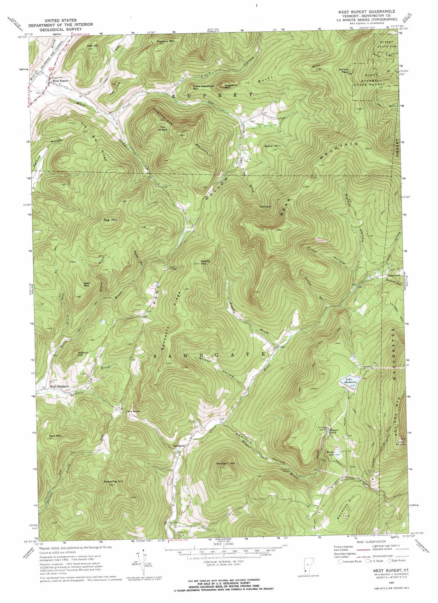
USGS Topo Quad 43073b2 - 1:24,000 scale
| Topo Map Name: | West Rupert |
| USGS Topo Quad ID: | 43073b2 |
| Print Size: | ca. 21 1/4" wide x 27" high |
| Southeast Coordinates: | 43.125° N latitude / 73.125° W longitude |
| Map Center Coordinates: | 43.1875° N latitude / 73.1875° W longitude |
| U.S. State: | VT |
| Filename: | o43073b2.jpg |
| Download Map JPG Image: | West Rupert topo map 1:24,000 scale |
| Map Type: | Topographic |
| Topo Series: | 7.5´ |
| Map Scale: | 1:24,000 |
| Source of Map Images: | United States Geological Survey (USGS) |
| Alternate Map Versions: |
West Rupert VT 1967, updated 1972 Download PDF Buy paper map West Rupert VT 1995, updated 2000 Download PDF Buy paper map West Rupert VT 2012 Download PDF Buy paper map West Rupert VT 2015 Download PDF Buy paper map |
| FStopo: | US Forest Service topo West Rupert is available: Download FStopo PDF Download FStopo TIF |
1:24,000 Topo Quads surrounding West Rupert
Fort Ann |
Granville |
Wells |
Middletown Springs |
Wallingford |
Hartford |
West Pawlet |
Pawlet |
Dorset |
Danby |
Cossayuna |
Salem |
West Rupert |
Manchester |
Peru |
Cambridge |
Shushan |
Arlington |
Sunderland |
Stratton Mountain |
Eagle Bridge |
Hoosick Falls |
Bennington |
Woodford |
Mount Snow |
> Back to 43073a1 at 1:100,000 scale
> Back to 43072a1 at 1:250,000 scale
> Back to U.S. Topo Maps home
West Rupert topo map: Gazetteer
West Rupert: Basins
The Oven elevation 565m 1853′West Rupert: Dams
Barbos Lake Dam elevation 562m 1843′Hooper Brook Dam elevation 686m 2250′
Hopper Brook Dam elevation 546m 1791′
Lake Madeleine Dam elevation 655m 2148′
West Rupert: Forests
Rupert State Forest elevation 643m 2109′West Rupert: Gaps
The Notch elevation 350m 1148′West Rupert: Lakes
Hopper Pond elevation 546m 1791′West Rupert: Populated Places
Beartown elevation 437m 1433′Sandgate elevation 245m 803′
West Rupert elevation 226m 741′
West Sandgate elevation 257m 843′
West Rupert: Reservoirs
Barbos Lake elevation 562m 1843′Lake Madeleine elevation 655m 2148′
West Rupert: Ridges
Bennetts Ridge elevation 679m 2227′The Big Ridge elevation 432m 1417′
West Rupert: Streams
Baker Brook elevation 389m 1276′Brown Brook elevation 324m 1062′
Devils Glen Brook elevation 282m 925′
Hopper Brook elevation 250m 820′
Mill Brook elevation 219m 718′
Norton Brook elevation 346m 1135′
Oven Brook elevation 401m 1315′
Pruddy Brook elevation 294m 964′
Sandgate Brook elevation 253m 830′
West Rupert: Summits
Bald Mountain elevation 590m 1935′Bass Hill elevation 501m 1643′
Bear Mountain elevation 1007m 3303′
Burnt Hill elevation 758m 2486′
Egg Mountain elevation 758m 2486′
Flat Hill elevation 408m 1338′
Haystack Mountain elevation 571m 1873′
Little Equinox elevation 1008m 3307′
Little Haystack Mountain elevation 432m 1417′
Masters Mountain elevation 576m 1889′
Minister Hill elevation 643m 2109′
Moffitt Mountain elevation 693m 2273′
Oak Hill elevation 448m 1469′
Pendock Hill elevation 704m 2309′
Shatterack Mountain elevation 722m 2368′
Spruce Peak elevation 855m 2805′
Swearing Hill elevation 635m 2083′
Tate Mountain elevation 511m 1676′
The Ox Bow elevation 533m 1748′
Walnut Hill elevation 478m 1568′
West Rupert: Swamps
Spruce Swamp (historical) elevation 663m 2175′West Rupert: Valleys
Clark Hollow elevation 286m 938′Corbett Hollow elevation 414m 1358′
Frost Hollow elevation 411m 1348′
Hamilton Hollow elevation 250m 820′
Kate Hollow elevation 400m 1312′
Kent Hollow elevation 284m 931′
Mears Hollow elevation 400m 1312′
Moffitt Hollow elevation 381m 1250′
Tidd Hollow elevation 251m 823′
Wilcox Hollow elevation 286m 938′
Youlin Hollow elevation 242m 793′
West Rupert digital topo map on disk
Buy this West Rupert topo map showing relief, roads, GPS coordinates and other geographical features, as a high-resolution digital map file on DVD:
New York, Vermont, Connecticut & Western Massachusetts
Buy digital topo maps: New York, Vermont, Connecticut & Western Massachusetts