Lexington Topo Map New York
To zoom in, hover over the map of Lexington
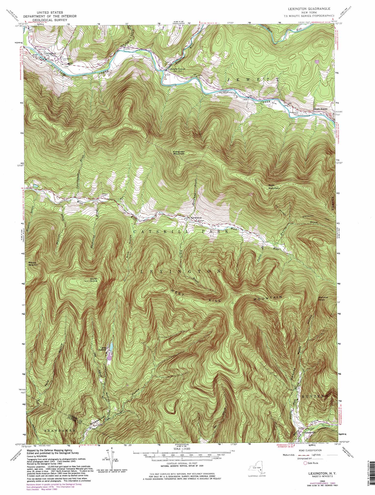
USGS Topo Quad 42074b3 - 1:24,000 scale
| Topo Map Name: | Lexington |
| USGS Topo Quad ID: | 42074b3 |
| Print Size: | ca. 21 1/4" wide x 27" high |
| Southeast Coordinates: | 42.125° N latitude / 74.25° W longitude |
| Map Center Coordinates: | 42.1875° N latitude / 74.3125° W longitude |
| U.S. State: | NY |
| Filename: | o42074b3.jpg |
| Download Map JPG Image: | Lexington topo map 1:24,000 scale |
| Map Type: | Topographic |
| Topo Series: | 7.5´ |
| Map Scale: | 1:24,000 |
| Source of Map Images: | United States Geological Survey (USGS) |
| Alternate Map Versions: |
Lexington NY 1946 Download PDF Buy paper map Lexington NY 1960, updated 1961 Download PDF Buy paper map Lexington NY 1960, updated 1968 Download PDF Buy paper map Lexington NY 1960, updated 1981 Download PDF Buy paper map Lexington NY 2010 Download PDF Buy paper map Lexington NY 2013 Download PDF Buy paper map Lexington NY 2016 Download PDF Buy paper map |
1:24,000 Topo Quads surrounding Lexington
Stamford |
Gilboa |
Livingstonville |
Durham |
Greenville |
Roxbury |
Prattsville |
Ashland |
Hensonville |
Freehold |
Fleischmanns |
West Kill |
Lexington |
Hunter |
Kaaterskill |
Seager |
Shandaken |
Phoenicia |
Bearsville |
Woodstock |
Claryville |
Peekamoose Mountain |
West Shokan |
Ashokan |
Kingston West |
> Back to 42074a1 at 1:100,000 scale
> Back to 42074a1 at 1:250,000 scale
> Back to U.S. Topo Maps home
Lexington topo map: Gazetteer
Lexington: Gaps
Diamond Notch elevation 814m 2670′Lexington: Populated Places
Jewett Center elevation 428m 1404′Lanesville elevation 390m 1279′
Lexington elevation 403m 1322′
South Jewett elevation 463m 1519′
Spruceton elevation 575m 1886′
Lexington: Streams
Bennett Brook elevation 485m 1591′East Kill elevation 421m 1381′
Hagadone Brook elevation 514m 1686′
Herdman Brook elevation 572m 1876′
Hollow Tree Brook elevation 390m 1279′
Hunter Brook elevation 627m 2057′
John Chase Brook elevation 415m 1361′
Newton Brook elevation 472m 1548′
Pettit Branch elevation 621m 2037′
Schoolhouse Brook elevation 498m 1633′
Styles Brook elevation 571m 1873′
Lexington: Summits
Evergreen Mountain elevation 1027m 3369′Mount Sherrill elevation 1082m 3549′
North Dome elevation 1096m 3595′
Rusk Mountain elevation 1121m 3677′
West Kill Mountain elevation 1186m 3891′
Lexington: Valleys
Diamond Notch Hollow elevation 391m 1282′Jay Hand Hollow elevation 371m 1217′
Mill Hollow elevation 421m 1381′
Mink Hollow elevation 536m 1758′
Ox Hollow elevation 685m 2247′
Lexington digital topo map on disk
Buy this Lexington topo map showing relief, roads, GPS coordinates and other geographical features, as a high-resolution digital map file on DVD:
New York, Vermont, Connecticut & Western Massachusetts
Buy digital topo maps: New York, Vermont, Connecticut & Western Massachusetts