New Lothrop Topo Map Michigan
To zoom in, hover over the map of New Lothrop
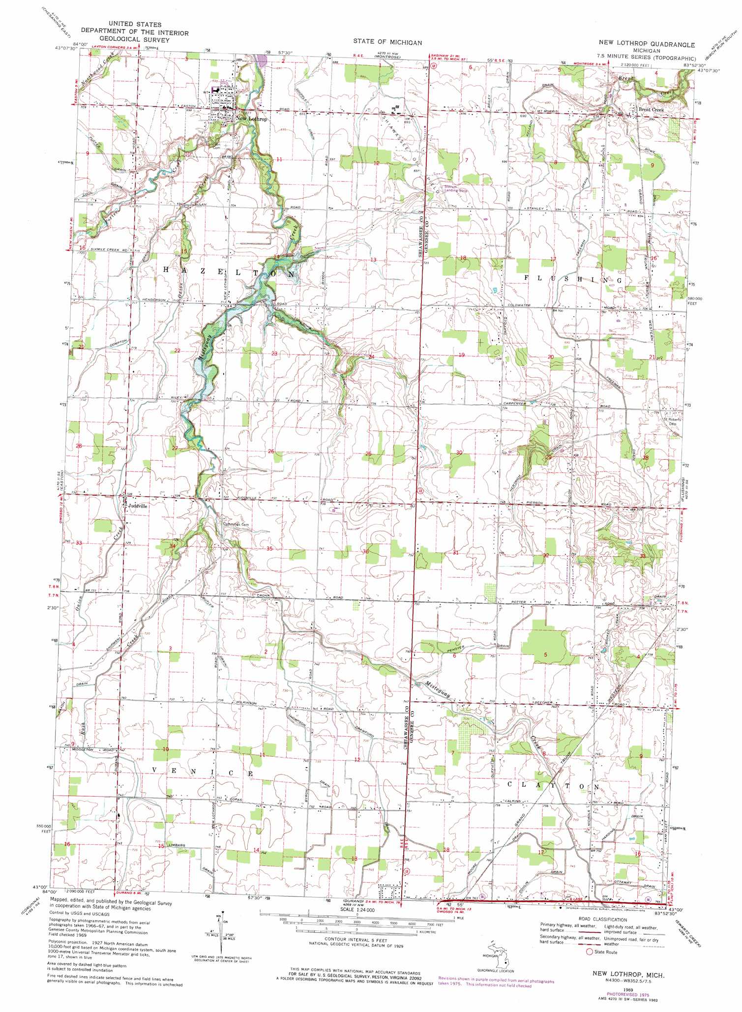
USGS Topo Quad 43083a8 - 1:24,000 scale
| Topo Map Name: | New Lothrop |
| USGS Topo Quad ID: | 43083a8 |
| Print Size: | ca. 21 1/4" wide x 27" high |
| Southeast Coordinates: | 43° N latitude / 83.875° W longitude |
| Map Center Coordinates: | 43.0625° N latitude / 83.9375° W longitude |
| U.S. State: | MI |
| Filename: | o43083a8.jpg |
| Download Map JPG Image: | New Lothrop topo map 1:24,000 scale |
| Map Type: | Topographic |
| Topo Series: | 7.5´ |
| Map Scale: | 1:24,000 |
| Source of Map Images: | United States Geological Survey (USGS) |
| Alternate Map Versions: |
New Lothrop MI 1969, updated 1971 Download PDF Buy paper map New Lothrop MI 1969, updated 1976 Download PDF Buy paper map New Lothrop MI 2011 Download PDF Buy paper map New Lothrop MI 2014 Download PDF Buy paper map New Lothrop MI 2016 Download PDF Buy paper map |
1:24,000 Topo Quads surrounding New Lothrop
Saint Charles |
Alicia |
Bridgeport |
Birch Run North |
Frankenmuth |
Chesaning West |
Chesaning East |
Montrose |
Birch Run South |
Clio |
Owosso North |
Easton |
New Lothrop |
Flushing |
Flint North |
Owosso South |
Corunna |
Durand |
Swartz Creek |
Flint South |
Perry |
Corunna Se |
Byron |
Linden |
Fenton |
> Back to 43083a1 at 1:100,000 scale
> Back to 43082a1 at 1:250,000 scale
> Back to U.S. Topo Maps home
New Lothrop topo map: Gazetteer
New Lothrop: Airports
Minarik Airport elevation 223m 731′New Lothrop: Canals
Butler Drain elevation 224m 734′Compton Drain elevation 218m 715′
Conlin Drain elevation 230m 754′
Crawford Drain elevation 226m 741′
Cronk Drain elevation 217m 711′
Crooked Creek Drain elevation 222m 728′
Freeman Drain elevation 212m 695′
Harding Drain elevation 230m 754′
Hertrich Drain elevation 219m 718′
Kelland Drain elevation 206m 675′
Moore Drain elevation 230m 754′
Ottaway Drain elevation 228m 748′
Penoyer Drain elevation 228m 748′
Puffer Drain elevation 216m 708′
Rowe Drain elevation 209m 685′
Shippley Drain elevation 210m 688′
Thompson Drain elevation 226m 741′
New Lothrop: Oilfields
Shiawassee Oil Field elevation 211m 692′New Lothrop: Parks
Brent Creek United Methodist Church Historical Marker elevation 209m 685′Judd's Corners Historical Marker elevation 221m 725′
Methodist Episcopal Church Historical Marker elevation 211m 692′
New Lothrop: Populated Places
Brent Creek elevation 209m 685′Juddville elevation 221m 725′
New Lothrop elevation 212m 695′
New Lothrop: Post Offices
Brentcreek Post Office (historical) elevation 209m 685′Hazelton Post Office (historical) elevation 217m 711′
Judd's Corners Post Office (historical) elevation 221m 725′
New Lothrop Post Office elevation 211m 692′
New Lothrop: Streams
Onion Creek elevation 204m 669′Porter Creek elevation 204m 669′
Rush Creek elevation 214m 702′
New Lothrop digital topo map on disk
Buy this New Lothrop topo map showing relief, roads, GPS coordinates and other geographical features, as a high-resolution digital map file on DVD:
 map DVD")