Elgin Topo Map Illinois
To zoom in, hover over the map of Elgin
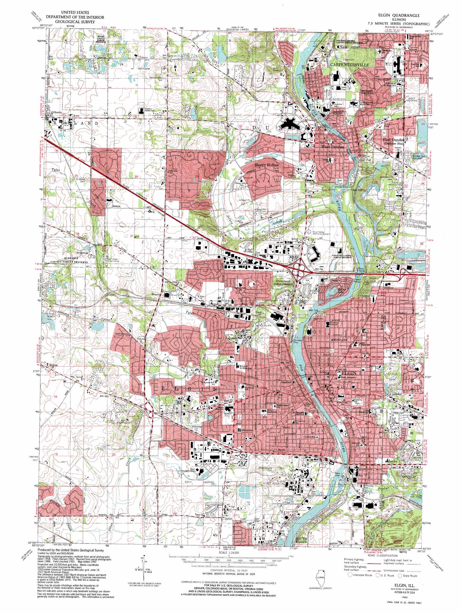
USGS Topo Quad 42088a3 - 1:24,000 scale
| Topo Map Name: | Elgin |
| USGS Topo Quad ID: | 42088a3 |
| Print Size: | ca. 21 1/4" wide x 27" high |
| Southeast Coordinates: | 42° N latitude / 88.25° W longitude |
| Map Center Coordinates: | 42.0625° N latitude / 88.3125° W longitude |
| U.S. State: | IL |
| Filename: | o42088a3.jpg |
| Download Map JPG Image: | Elgin topo map 1:24,000 scale |
| Map Type: | Topographic |
| Topo Series: | 7.5´ |
| Map Scale: | 1:24,000 |
| Source of Map Images: | United States Geological Survey (USGS) |
| Alternate Map Versions: |
Elgin IL 1962, updated 1964 Download PDF Buy paper map Elgin IL 1962, updated 1973 Download PDF Buy paper map Elgin IL 1962, updated 1981 Download PDF Buy paper map Elgin IL 1962, updated 1989 Download PDF Buy paper map Elgin IL 1992, updated 1992 Download PDF Buy paper map Elgin IL 1998, updated 2002 Download PDF Buy paper map Elgin IL 2012 Download PDF Buy paper map Elgin IL 2015 Download PDF Buy paper map |
1:24,000 Topo Quads surrounding Elgin
Marengo North |
Woodstock |
Mchenry |
Wauconda |
Grayslake |
Marengo South |
Huntley |
Crystal Lake |
Barrington |
Lake Zurich |
Hampshire |
Pingree Grove |
Elgin |
Streamwood |
Palatine |
Maple Park |
Elburn |
Geneva |
West Chicago |
Lombard |
Big Rock |
Sugar Grove |
Aurora North |
Naperville |
Wheaton |
> Back to 42088a1 at 1:100,000 scale
> Back to 42088a1 at 1:250,000 scale
> Back to U.S. Topo Maps home
Elgin topo map: Gazetteer
Elgin: Airports
American Antenna Heliport elevation 250m 820′Capsonic Group Heliport elevation 250m 820′
Illinois Department of Transportation Heliport elevation 226m 741′
Olivers Heliport elevation 271m 889′
Rods Fox Valley Seaplane Base elevation 231m 757′
Saint Joseph Hospital Medical Center Heliport elevation 250m 820′
Sherman Hospital Heliport elevation 239m 784′
Elgin: Dams
Tara Lake Dam elevation 250m 820′Elgin: Lakes
Willow Lake elevation 217m 711′Elgin: Parks
Aldis Park elevation 219m 718′Binnie County Forest Preserve elevation 274m 898′
Bluff Springs Fen Nature Preserve elevation 216m 708′
Burnidge County Forest Preserve elevation 285m 935′
Carpenter Park elevation 225m 738′
Central Park elevation 227m 744′
Channing Park elevation 239m 784′
College Green Park elevation 243m 797′
College Park elevation 243m 797′
Drake Field Park elevation 225m 738′
Elgin Shores County Forest Preserve elevation 220m 721′
Elgin Sports Complex elevation 248m 813′
Fox River Fen Nature Preserve elevation 219m 718′
Freeman Park elevation 222m 728′
Hawthorne Park elevation 250m 820′
Kiwanis Park elevation 220m 721′
Lions Park elevation 252m 826′
Lords Park elevation 238m 780′
Maiden Lane Park elevation 221m 725′
Marie Grolich Park elevation 218m 715′
Millennium Park elevation 246m 807′
Poplar Creek County Forest Preserve elevation 214m 702′
Raceway Woods County Forest Preserve elevation 240m 787′
Randall Oaks Park elevation 275m 902′
Robert Sperry Park elevation 240m 787′
Sabatino Park elevation 226m 741′
Saint Francis Park elevation 238m 780′
Santa's Village Amusement Park elevation 263m 862′
Schweitzer County Forest Park elevation 268m 879′
South End Park elevation 221m 725′
Tower Park elevation 232m 761′
Triangle Park elevation 220m 721′
Trout Park elevation 244m 800′
Trout Park Nature Preserve elevation 229m 751′
Tyler Creek Forest Preserve elevation 237m 777′
Voyagers Landing County Forest Preserve elevation 219m 718′
Willow Bay Park elevation 243m 797′
Wing Park elevation 236m 774′
Wright Avenue Park elevation 226m 741′
Zayres Park elevation 252m 826′
Elgin: Populated Places
Almora elevation 263m 862′Almora Heights elevation 261m 856′
Binnie Hills elevation 276m 905′
Binnie Lakes elevation 276m 905′
Carpentersville elevation 271m 889′
Clintonville elevation 232m 761′
East Dundee elevation 234m 767′
Elgin elevation 227m 744′
Gilberts elevation 274m 898′
Hidden Hill elevation 273m 895′
Highland Haven elevation 269m 882′
Illinois Park elevation 244m 800′
Sleepy Hollow elevation 225m 738′
Weldwood Oaks elevation 263m 862′
West Dundee elevation 232m 761′
West Highland Acres elevation 267m 875′
Wildwood Valley elevation 283m 928′
Williamsburg Green elevation 275m 902′
Elgin: Post Offices
Elgin Post Office elevation 226m 741′Elgin: Reservoirs
Tara Lake elevation 250m 820′Elgin: Streams
Fitchie Creek elevation 237m 777′Jelkes Creek elevation 216m 708′
No Name Creek elevation 218m 715′
Poplar Creek elevation 213m 698′
Tyler Creek elevation 214m 702′
Elgin: Swamps
Bluff Spring Fen elevation 225m 738′Elgin digital topo map on disk
Buy this Elgin topo map showing relief, roads, GPS coordinates and other geographical features, as a high-resolution digital map file on DVD:
Northern Illinois, Northern Indiana & Southwestern Michigan
Buy digital topo maps: Northern Illinois, Northern Indiana & Southwestern Michigan