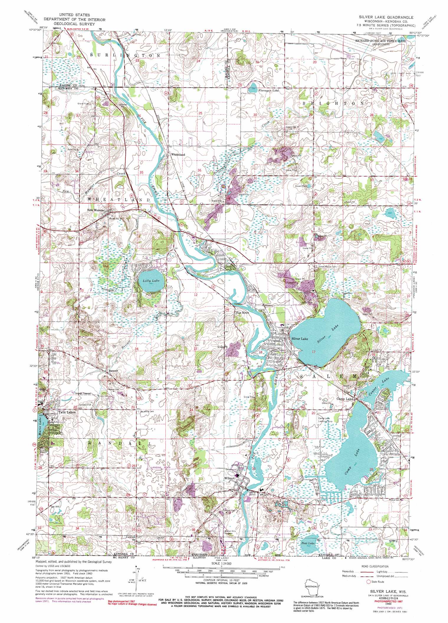
Silver Lake Topo Map Wisconsin
To zoom in, hover over the map of Silver Lake
USGS Topo Quad 42088e2 - 1:24,000 scale
| Topo Map Name: | Silver Lake |
| USGS Topo Quad ID: | 42088e2 |
| Print Size: | ca. 21 1/4" wide x 27" high |
| Southeast Coordinates: | 42.5° N latitude / 88.125° W longitude |
| Map Center Coordinates: | 42.5625° N latitude / 88.1875° W longitude |
| U.S. State: | WI |
| Filename: | o42088e2.jpg |
| Download Map JPG Image: | Silver Lake topo map 1:24,000 scale |
| Map Type: | Topographic |
| Topo Series: | 7.5´ |
| Map Scale: | 1:24,000 |
| Source of Map Images: | United States Geological Survey (USGS) |
| Alternate Map Versions: |
Silver Lake WI 1960, updated 1962 Download PDF Buy paper map Silver Lake WI 1960, updated 1972 Download PDF Buy paper map Silver Lake WI 1960, updated 1991 Download PDF Buy paper map Silver Lake WI 2010 Download PDF Buy paper map Silver Lake WI 2013 Download PDF Buy paper map Silver Lake WI 2016 Download PDF Buy paper map |
1:24,000 Topo Quads surrounding Silver Lake
East Troy |
Mukwonago |
Waterford |
North Cape |
Franksville |
Springfield |
Burlington |
Rochester |
Union Grove |
Sturtevant |
Lake Geneva |
Genoa City |
Silver Lake |
Paddock Lake |
Pleasant Prairie |
Hebron |
Richmond |
Fox Lake |
Antioch |
Wadsworth |
Woodstock |
Mchenry |
Wauconda |
Grayslake |
Libertyville |
> Back to 42088e1 at 1:100,000 scale
> Back to 42088a1 at 1:250,000 scale
> Back to U.S. Topo Maps home
Silver Lake topo map: Gazetteer
Silver Lake: Airports
Camp Lake Airport elevation 229m 751′Foxewood Airport elevation 227m 744′
Westosha Airport elevation 259m 849′
Westosha Emergency Center Heliport elevation 228m 748′
Silver Lake: Lakes
Camp Lake elevation 225m 738′Flanagan Lake elevation 233m 764′
Lilly Lake elevation 230m 754′
Silver Lake elevation 228m 748′
Silver Lake: Parks
Fox River Park elevation 233m 764′New Munster Bog Island State Natural Area elevation 241m 790′
Silver Lake Bog State Natural Area elevation 235m 770′
Silver Lake: Populated Places
Bassett elevation 238m 780′Camp Lake elevation 229m 751′
Fox River elevation 233m 764′
New Munster elevation 242m 793′
Silver Lake elevation 230m 754′
Twin Lakes elevation 244m 800′
Wheatland elevation 231m 757′
Wheatland Estates elevation 232m 761′
Wilmot elevation 229m 751′
Silver Lake: Reservoirs
Center Lake elevation 226m 741′Silver Lake: Streams
Bassett Creek elevation 227m 744′New Munster Creek elevation 228m 748′
Palmer Creek elevation 228m 748′
Peterson Creek elevation 228m 748′
Silver Lake digital topo map on disk
Buy this Silver Lake topo map showing relief, roads, GPS coordinates and other geographical features, as a high-resolution digital map file on DVD:
Northern Illinois, Northern Indiana & Southwestern Michigan
Buy digital topo maps: Northern Illinois, Northern Indiana & Southwestern Michigan