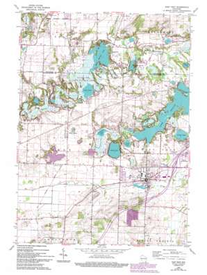
East Troy Topo Map Wisconsin
To zoom in, hover over the map of East Troy
USGS Topo Quad 42088g4 - 1:24,000 scale
| Topo Map Name: | East Troy |
| USGS Topo Quad ID: | 42088g4 |
| Print Size: | ca. 21 1/4" wide x 27" high |
| Southeast Coordinates: | 42.75° N latitude / 88.375° W longitude |
| Map Center Coordinates: | 42.8125° N latitude / 88.4375° W longitude |
| U.S. State: | WI |
| Filename: | o42088g4.jpg |
| Download Map JPG Image: | East Troy topo map 1:24,000 scale |
| Map Type: | Topographic |
| Topo Series: | 7.5´ |
| Map Scale: | 1:24,000 |
| Source of Map Images: | United States Geological Survey (USGS) |
| Alternate Map Versions: |
East Troy WI 1960, updated 1964 Download PDF Buy paper map East Troy WI 1960, updated 1972 Download PDF Buy paper map East Troy WI 1960, updated 1977 Download PDF Buy paper map East Troy WI 1960, updated 1994 Download PDF Buy paper map East Troy WI 2010 Download PDF Buy paper map East Troy WI 2013 Download PDF Buy paper map East Troy WI 2016 Download PDF Buy paper map |
1:24,000 Topo Quads surrounding East Troy
> Back to 42088e1 at 1:100,000 scale
> Back to 42088a1 at 1:250,000 scale
> Back to U.S. Topo Maps home
East Troy topo map: Gazetteer
East Troy: Bays
Broad Bay elevation 246m 807′Brooks Bay elevation 246m 807′
Hateleys Bay elevation 246m 807′
West Bay elevation 246m 807′
East Troy: Capes
Weldons Point elevation 248m 813′Wilmers Point elevation 247m 810′
East Troy: Dams
Kettle Moraine Estates 3WR1719 Dam elevation 270m 885′Kettle Morraine Estates Corporation 3WR1719 Dam elevation 268m 879′
Lake Beulah Dam elevation 247m 810′
Pabst Dam elevation 259m 849′
Wambold Dam elevation 250m 820′
East Troy: Islands
Beulah Island elevation 248m 813′Fairy Island elevation 250m 820′
Twin Islands elevation 247m 810′
East Troy: Lakes
Army Lake elevation 247m 810′Booth Lake elevation 249m 816′
Lulu Lake elevation 250m 820′
Mill Lake elevation 246m 807′
Pickerel Lake elevation 247m 810′
Rainbow Springs Lake elevation 246m 807′
Swan Lake elevation 247m 810′
Wood Lake elevation 243m 797′
East Troy: Parks
Beulah Bog State Natural Area elevation 262m 859′Eagle Centre Prairie State Natural Area elevation 288m 944′
Lulu Lake State Natural Area elevation 251m 823′
Mukwonago Park elevation 262m 859′
Pickerel Lake Fen State Natural Area elevation 248m 813′
East Troy: Populated Places
Army Lake (historical) elevation 253m 830′Eagleville elevation 250m 820′
East Troy elevation 262m 859′
Mayhews (historical) elevation 262m 859′
Skyview Terrace elevation 262m 859′
Troy elevation 265m 869′
Troy Center elevation 271m 889′
East Troy: Reservoirs
2 Reservoir elevation 270m 885′2 Reservoir elevation 268m 879′
Eagle Spring Lake elevation 252m 826′
Eagle Spring Lake 22 elevation 250m 820′
Lake Beulah elevation 247m 810′
Lake Beulah 10 elevation 246m 807′
Pabst Lake 5 elevation 259m 849′
East Troy: Streams
Jericho Creek elevation 250m 820′East Troy digital topo map on disk
Buy this East Troy topo map showing relief, roads, GPS coordinates and other geographical features, as a high-resolution digital map file on DVD:
Northern Illinois, Northern Indiana & Southwestern Michigan
Buy digital topo maps: Northern Illinois, Northern Indiana & Southwestern Michigan


