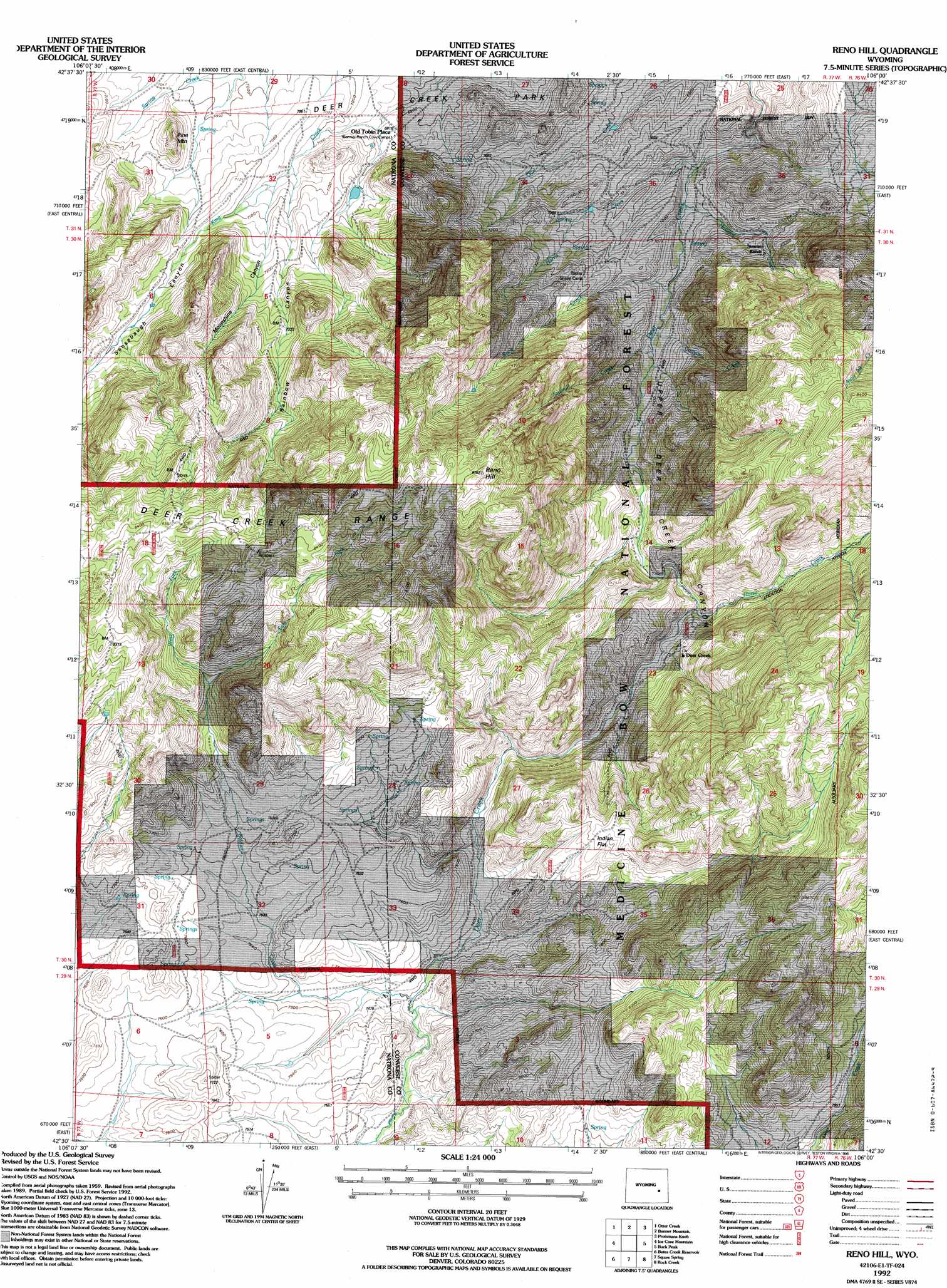
Reno Hill Topo Map Wyoming
To zoom in, hover over the map of Reno Hill
USGS Topo Quad 42106e1 - 1:24,000 scale
| Topo Map Name: | Reno Hill |
| USGS Topo Quad ID: | 42106e1 |
| Print Size: | ca. 21 1/4" wide x 27" high |
| Southeast Coordinates: | 42.5° N latitude / 106° W longitude |
| Map Center Coordinates: | 42.5625° N latitude / 106.0625° W longitude |
| U.S. State: | WY |
| Filename: | o42106e1.jpg |
| Download Map JPG Image: | Reno Hill topo map 1:24,000 scale |
| Map Type: | Topographic |
| Topo Series: | 7.5´ |
| Map Scale: | 1:24,000 |
| Source of Map Images: | United States Geological Survey (USGS) |
| Alternate Map Versions: |
Reno Hill WY 1960, updated 1965 Download PDF Buy paper map Reno Hill WY 1960, updated 1974 Download PDF Buy paper map Reno Hill WY 1960, updated 1985 Download PDF Buy paper map Reno Hill WY 1992, updated 1996 Download PDF Buy paper map Reno Hill WY 2012 Download PDF Buy paper map Reno Hill WY 2015 Download PDF Buy paper map |
| FStopo: | US Forest Service topo Reno Hill is available: Download FStopo PDF Download FStopo TIF |
1:24,000 Topo Quads surrounding Reno Hill
Casper |
Brookhurst |
Lockett |
Parkerton |
Glenrock |
Crimson Dawn |
Otter Creek |
Banner Mountain |
Protsmans Knob |
Root Creek |
Sheep Creek |
Ice Cave Mountain |
Reno Hill |
Buck Peak |
Buffalo Peak |
Mud Springs |
Bates Creek Reservoir |
Squaw Spring |
Rock Creek |
Warbonnett Peak |
Measel Spring Reservoir |
Moss Agate Reservoir |
Chalk Hills |
Pass Creek |
Marshall |
> Back to 42106e1 at 1:100,000 scale
> Back to 42106a1 at 1:250,000 scale
> Back to U.S. Topo Maps home
Reno Hill topo map: Gazetteer
Reno Hill: Flats
Indian Flat elevation 2378m 7801′Reno Hill: Streams
Buck Creek elevation 2115m 6938′Canyon Creek elevation 2118m 6948′
East Fork Soldier Creek elevation 2376m 7795′
Harris Creek elevation 2099m 6886′
Horse Creek elevation 2177m 7142′
Howard Creek elevation 2097m 6879′
Sawmill Creek elevation 2118m 6948′
Soldier Creek elevation 2257m 7404′
West Fork elevation 2376m 7795′
West Fork Soldier Creek elevation 2376m 7795′
Reno Hill: Summits
Pine Mountain elevation 2200m 7217′Reno Hill elevation 2642m 8667′
Six Horse Hill elevation 2448m 8031′
Reno Hill: Valleys
Hay Draw elevation 2557m 8389′Moonshine Canyon elevation 2155m 7070′
Rainbow Canyon elevation 2148m 7047′
Sensebaugh Canyon elevation 2177m 7142′
Upper Deer Creek Canyon elevation 2096m 6876′
Reno Hill digital topo map on disk
Buy this Reno Hill topo map showing relief, roads, GPS coordinates and other geographical features, as a high-resolution digital map file on DVD:
Eastern Wyoming & Western South Dakota
Buy digital topo maps: Eastern Wyoming & Western South Dakota