Mount Emily Topo Map Oregon
To zoom in, hover over the map of Mount Emily
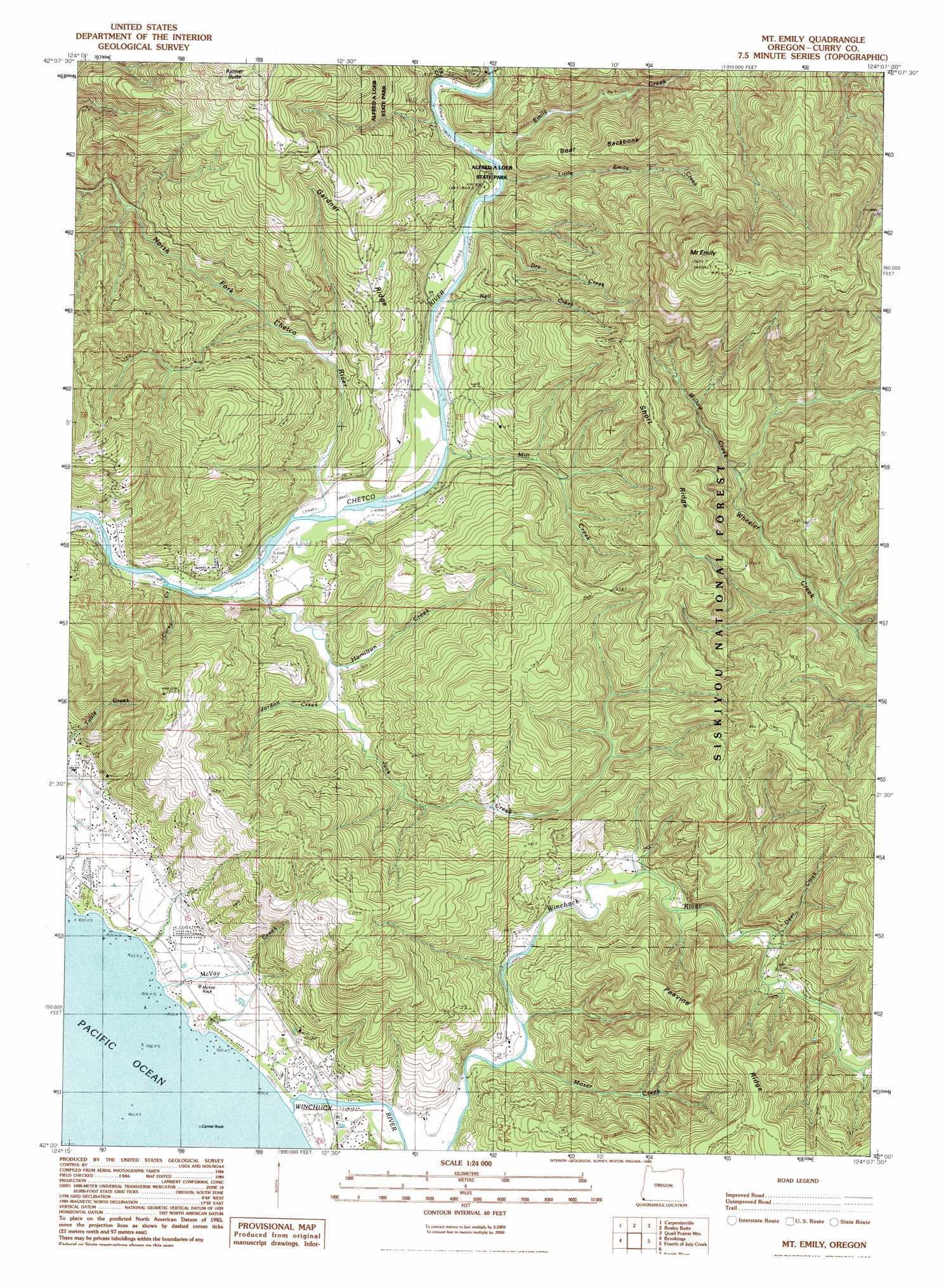
USGS Topo Quad 42124a2 - 1:24,000 scale
| Topo Map Name: | Mount Emily |
| USGS Topo Quad ID: | 42124a2 |
| Print Size: | ca. 21 1/4" wide x 27" high |
| Southeast Coordinates: | 42° N latitude / 124.125° W longitude |
| Map Center Coordinates: | 42.0625° N latitude / 124.1875° W longitude |
| U.S. State: | OR |
| Filename: | o42124a2.jpg |
| Download Map JPG Image: | Mount Emily topo map 1:24,000 scale |
| Map Type: | Topographic |
| Topo Series: | 7.5´ |
| Map Scale: | 1:24,000 |
| Source of Map Images: | United States Geological Survey (USGS) |
| Alternate Map Versions: |
Mt. Emily OR 1989, updated 1989 Download PDF Buy paper map Mount Emily OR 1996, updated 1999 Download PDF Buy paper map Mount Emily OR 2011 Download PDF Buy paper map Mount Emily OR 2014 Download PDF Buy paper map |
| FStopo: | US Forest Service topo Mount Emily is available: Download FStopo PDF Download FStopo TIF |
1:24,000 Topo Quads surrounding Mount Emily
Cape Sebastian |
Sundown Mountain |
Collier Butte |
Big Craggies |
Tincup Peak |
Mack Point |
Carpenterville |
Bosley Butte |
Quail Prairie Mountain |
Chetco Peak |
Brookings |
Mount Emily |
Fourth Of July Creek |
Biscuit Hill |
|
Smith River |
High Divide |
High Plateau Mountain |
||
Crescent City |
Hiouchi |
Gasquet |
> Back to 42124a1 at 1:100,000 scale
> Back to 42124a1 at 1:250,000 scale
> Back to U.S. Topo Maps home
Mount Emily topo map: Gazetteer
Mount Emily: Bars
Ostenbery Bar elevation 9m 29′Mount Emily: Islands
Camel Rock elevation 0m 0′Mount Emily: Parks
Alfred A Loeb State Park elevation 50m 164′Crissey Field State Park elevation 5m 16′
McVay Rock State Park elevation 14m 45′
Winchuck State Park elevation 75m 246′
Mount Emily: Pillars
McVay Rock elevation 21m 68′Tide Rock elevation 6m 19′
Mount Emily: Post Offices
Chetco Post Office (historical) elevation 42m 137′Winchuck Post Office (historical) elevation 6m 19′
Mount Emily: Ridges
Boar Backbone elevation 272m 892′Gardner Ridge elevation 339m 1112′
Peavine Ridge elevation 408m 1338′
Short Ridge elevation 409m 1341′
Mount Emily: Streams
Carey Creek elevation 8m 26′Cooley Creek elevation 5m 16′
Deer Creek elevation 25m 82′
Dry Creek elevation 12m 39′
Elk Creek elevation 23m 75′
Emily Creek elevation 15m 49′
Hamilton Creek elevation 36m 118′
Jack Creek elevation 9m 29′
Johnson Creek elevation 11m 36′
Jordan Creek elevation 27m 88′
Little Emily Creek elevation 15m 49′
McVay Creek elevation 14m 45′
Mill Creek elevation 11m 36′
Moore Creek elevation 3m 9′
Moser Creek elevation 8m 26′
Nell Creek elevation 12m 39′
North Fork Chetco River elevation 9m 29′
Ram Creek elevation 12m 39′
Wildcat Creek elevation 60m 196′
Willow Creek elevation 161m 528′
Winchuck River elevation 2m 6′
Mount Emily: Summits
Mount Emily elevation 880m 2887′Mount Emily: Trails
Elk Mountain Trail elevation 423m 1387′Mount Emily digital topo map on disk
Buy this Mount Emily topo map showing relief, roads, GPS coordinates and other geographical features, as a high-resolution digital map file on DVD: