Cape Elizabeth Topo Map Maine
To zoom in, hover over the map of Cape Elizabeth
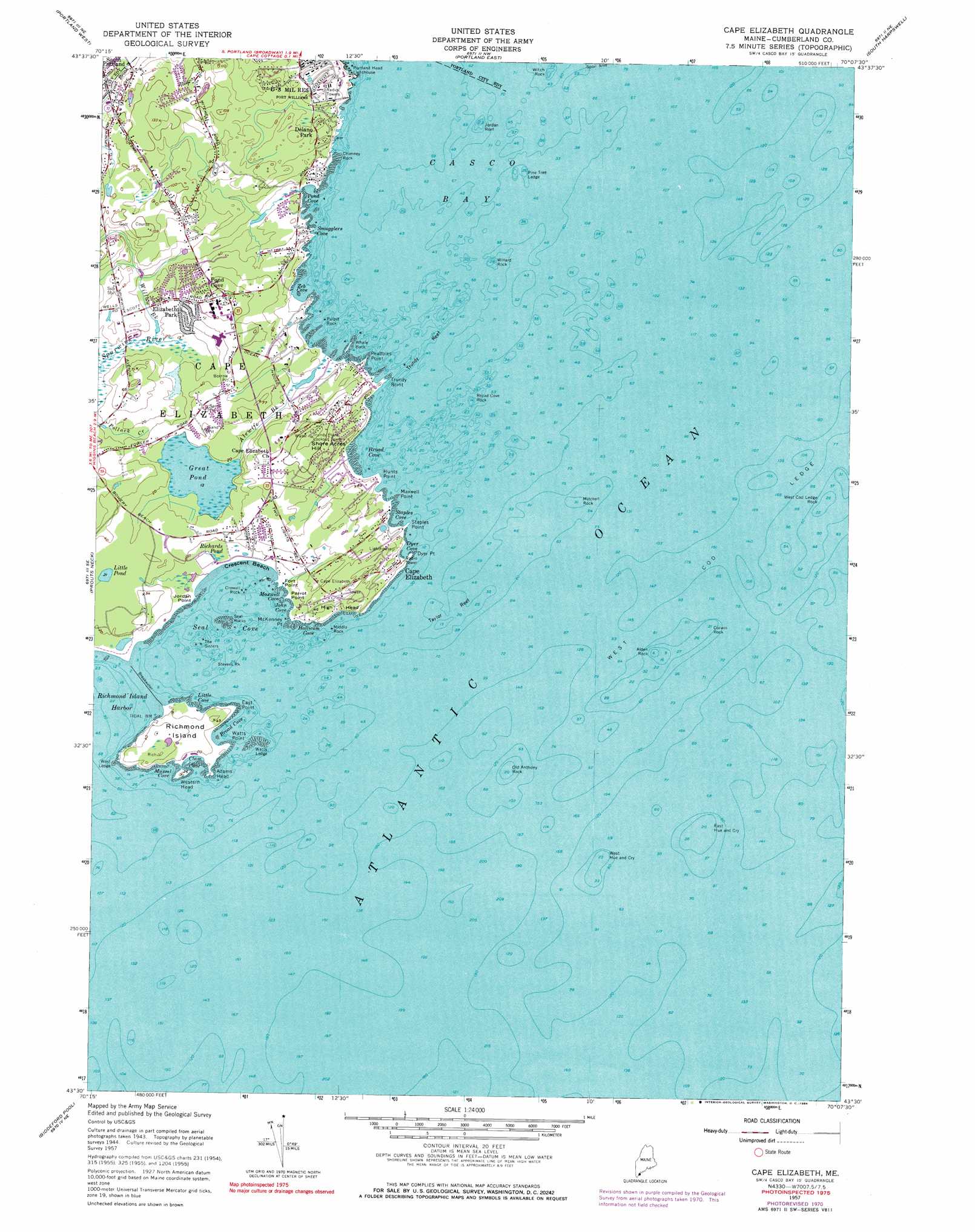
USGS Topo Quad 43070e2 - 1:24,000 scale
| Topo Map Name: | Cape Elizabeth |
| USGS Topo Quad ID: | 43070e2 |
| Print Size: | ca. 21 1/4" wide x 27" high |
| Southeast Coordinates: | 43.5° N latitude / 70.125° W longitude |
| Map Center Coordinates: | 43.5625° N latitude / 70.1875° W longitude |
| U.S. State: | ME |
| Filename: | o43070e2.jpg |
| Download Map JPG Image: | Cape Elizabeth topo map 1:24,000 scale |
| Map Type: | Topographic |
| Topo Series: | 7.5´ |
| Map Scale: | 1:24,000 |
| Source of Map Images: | United States Geological Survey (USGS) |
| Alternate Map Versions: |
Cape Elizabeth ME 1944 Download PDF Buy paper map Cape Elizabeth ME 1957, updated 1958 Download PDF Buy paper map Cape Elizabeth ME 1957, updated 1971 Download PDF Buy paper map Cape Elizabeth ME 1957, updated 1984 Download PDF Buy paper map Cape Elizabeth ME 2011 Download PDF Buy paper map Cape Elizabeth ME 2014 Download PDF Buy paper map |
1:24,000 Topo Quads surrounding Cape Elizabeth
North Windham |
Cumberland Center |
Yarmouth |
Freeport |
Orrs Island |
Gorham |
Portland West |
Portland East |
South Harpswell |
Bailey Island |
Old Orchard Beach |
Prouts Neck |
Cape Elizabeth |
||
Biddeford |
Biddeford Pool |
|||
Kennebunkport |
> Back to 43070e1 at 1:100,000 scale
> Back to 43070a1 at 1:250,000 scale
> Back to U.S. Topo Maps home
Cape Elizabeth topo map: Gazetteer
Cape Elizabeth: Bars
Alden Rock elevation 0m 0′Broad Cove Rock elevation 0m 0′
Chimney Rock elevation 0m 0′
Corwin Rock elevation 0m 0′
Crowell Rock elevation 0m 0′
East Hue and Cry elevation 0m 0′
Jordan Reef elevation 0m 0′
Middle Rock elevation 0m 0′
Mitchell Rock elevation 0m 0′
Old Anthony Rock elevation 0m 0′
Pine Tree Ledge elevation 0m 0′
Pulpit Rock elevation 0m 0′
Seal Rocks elevation 0m 0′
Stevens Rock elevation 0m 0′
Taylor Reef elevation 0m 0′
The Sisters elevation 0m 0′
Trundy Reef elevation 0m 0′
Watts Ledge elevation 0m 0′
West Cod Ledge elevation 0m 0′
West Cod Ledge Rock elevation 0m 0′
West Hue and Cry elevation 0m 0′
West Ledge elevation 0m 0′
Whale Back elevation 0m 0′
Willard Rock elevation 0m 0′
Witch Rock elevation 0m 0′
Cape Elizabeth: Bays
Boat Cove elevation 0m 0′Broad Cove elevation 0m 0′
Broad Cove elevation 0m 0′
Clam Cove elevation 0m 0′
Dyer Cove elevation 0m 0′
Hallicom Cove elevation 0m 0′
John Cove elevation 0m 0′
Little Cove elevation 0m 0′
Maxwell Cove elevation 0m 0′
Mussel Cove elevation 0m 0′
Pond Cove elevation 0m 0′
Richmond Island Harbor elevation 0m 0′
Seal Cove elevation 0m 0′
Smugglers Cove elevation 0m 0′
Spring Cove elevation 0m 0′
Staples Cove elevation 0m 0′
Zeb Cove elevation 0m 0′
Cape Elizabeth: Beaches
Crescent Beach elevation 1m 3′Cape Elizabeth: Capes
Adams Head elevation 1m 3′Cape Elizabeth elevation 3m 9′
Dyer Point elevation 0m 0′
East Point elevation 0m 0′
Fort Point elevation 1m 3′
High Head elevation 9m 29′
Hunts Point elevation 1m 3′
Jordan Point elevation 2m 6′
Maxwell Point elevation 1m 3′
McKenney Point elevation 0m 0′
Parrot Point elevation 1m 3′
Peabbles Point elevation 0m 0′
Staples Point elevation 0m 0′
Trundy Point elevation 0m 0′
Watts Point elevation 0m 0′
Western Head elevation 7m 22′
Cape Elizabeth: Islands
Richmond Island elevation 12m 39′Cape Elizabeth: Lakes
Great Pond elevation 4m 13′Little Pond elevation 6m 19′
Richards Pond elevation 3m 9′
Cape Elizabeth: Parks
Crescent Beach State Park elevation 2m 6′Fort Williams Park elevation 13m 42′
Two Lights State Park elevation 20m 65′
Cape Elizabeth: Populated Places
Cape Elizabeth elevation 6m 19′Delano Park elevation 17m 55′
Elizabeth Park elevation 15m 49′
Pond Cove elevation 32m 104′
Cape Elizabeth: Streams
Alewife Brook elevation 0m 0′Pond Cove Brook elevation 0m 0′
Willow Brook elevation 5m 16′
Cape Elizabeth: Summits
Blue Hill elevation 43m 141′Shore Acres Hill elevation 43m 141′
Cape Elizabeth digital topo map on disk
Buy this Cape Elizabeth topo map showing relief, roads, GPS coordinates and other geographical features, as a high-resolution digital map file on DVD:
Maine, New Hampshire, Rhode Island & Eastern Massachusetts
Buy digital topo maps: Maine, New Hampshire, Rhode Island & Eastern Massachusetts