Portland Topo Map Maine
To zoom in, hover over the map of Portland
USGS Topo Map 43070e1 - 1:100,000 scale
| Topo Map Name: | Portland |
| USGS Topo Quad ID: | 43070e1 |
| Print Size: | ca. 39" wide x 24" high |
| Southeast Coordinates: | 43.5° N latitude / 70° W longitude |
| Map Center Coordinates: | 43.75° N latitude / 70.5° W longitude |
| U.S. States: | ME, NH |
| Filename: | 43070e1.jpg |
| Download Map JPG Image: | Portland topo map 1:100,000 scale |
| Map Type: | Topographic |
| Topo Series: | 30´x60´ |
| Map Scale: | 1:100,000 |
| Source of Map Images: | United States Geological Survey (USGS) |
| Alternate Map Versions: |
Portland ME 1985, updated 1986 Download PDF Buy paper map Portland ME 1985, updated 1988 Download PDF Buy paper map |
1:100,000 Topos surrounding Portland
Mount Washington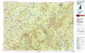 |
Lewiston |
Augusta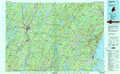 |
Lake Winnipesaukee |
Portland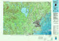 |
Bath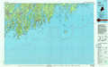 |
Concord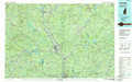 |
Kittery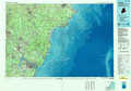 |
> Back to 43070a1 at 1:250,000 scale
> Back to U.S. Topo Maps home
1:24,000 Topo Quads covered by the spatial extent of this 100k map (Portland)
|
Brownfield 
|
Hiram 
|
North Sebago 
|
Naples 
|
Raymond 
|
Gray 
|
North Pownal 
|
Lisbon Falls South 
|
|
Kezar Falls 
|
Cornish 
|
Steep Falls 
|
Sebago Lake 
|
North Windham 
|
Cumberland Center 
|
Yarmouth 
|
Freeport 
|
|
West Newfield 
|
Limerick 
|
Limington 
|
Standish 
|
Gorham 
|
Portland West 
|
Portland East 
|
South Harpswell 
|
|
Great East Lake 
|
Mousam Lake 
|
Waterboro 
|
Bar Mills 
|
Old Orchard Beach 
|
Prouts Neck 
|
Cape Elizabeth 
|
