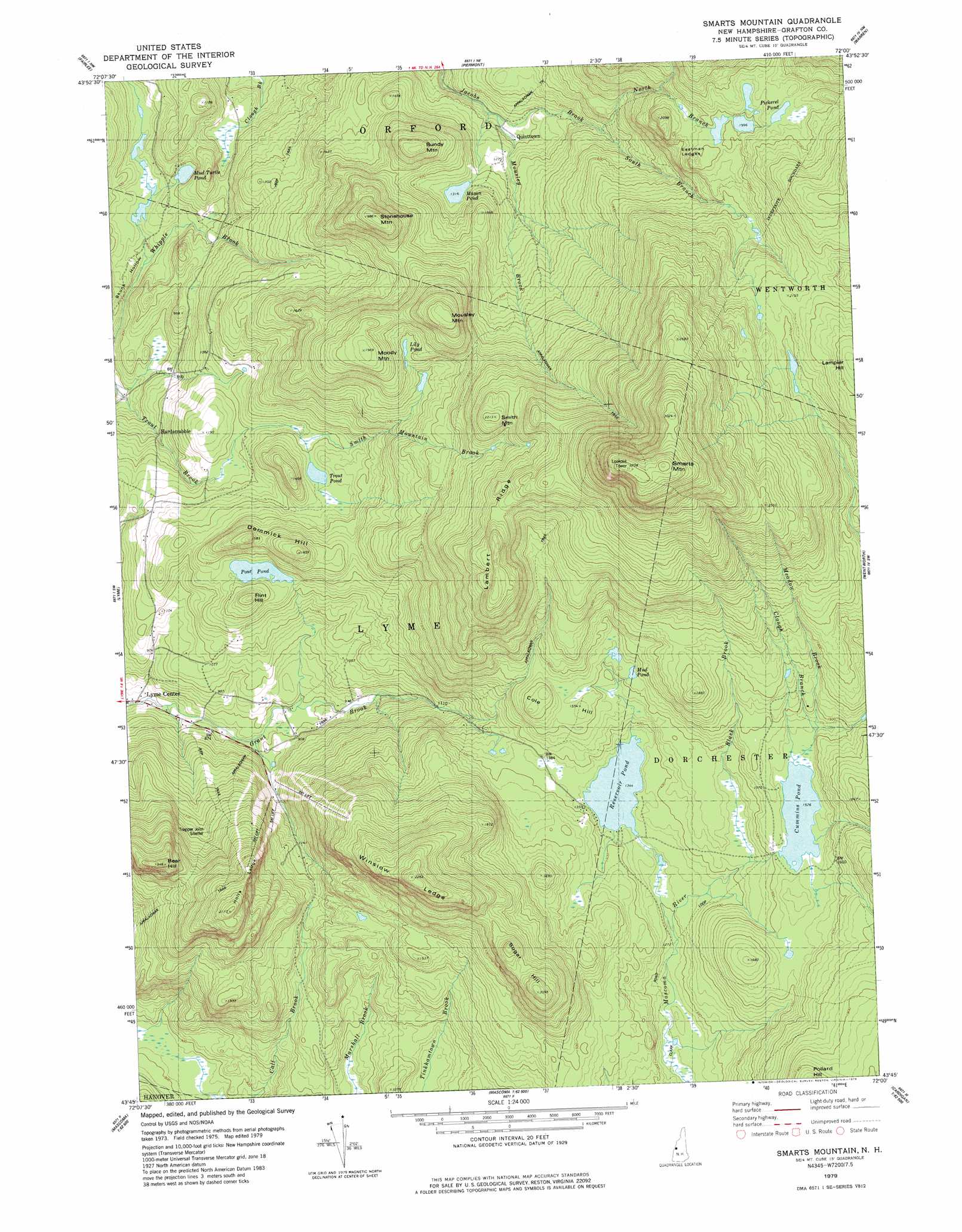
Smarts Mountain Topo Map New Hampshire
To zoom in, hover over the map of Smarts Mountain
USGS Topo Quad 43072g1 - 1:24,000 scale
| Topo Map Name: | Smarts Mountain |
| USGS Topo Quad ID: | 43072g1 |
| Print Size: | ca. 21 1/4" wide x 27" high |
| Southeast Coordinates: | 43.75° N latitude / 72° W longitude |
| Map Center Coordinates: | 43.8125° N latitude / 72.0625° W longitude |
| U.S. State: | NH |
| Filename: | o43072g1.jpg |
| Download Map JPG Image: | Smarts Mountain topo map 1:24,000 scale |
| Map Type: | Topographic |
| Topo Series: | 7.5´ |
| Map Scale: | 1:24,000 |
| Source of Map Images: | United States Geological Survey (USGS) |
| Alternate Map Versions: |
Smarts Mountain NH 1979, updated 1979 Download PDF Buy paper map Smarts Mountain NH 1996, updated 2001 Download PDF Buy paper map Smarts Mountain NH 2012 Download PDF Buy paper map Smarts Mountain NH 2015 Download PDF Buy paper map |
| FStopo: | US Forest Service topo Smarts Mountain is available: Download FStopo PDF Download FStopo TIF |
1:24,000 Topo Quads surrounding Smarts Mountain
West Topsham |
East Corinth |
Newbury |
East Haverhill |
Mount Moosilauke |
Vershire |
Fairlee |
Piermont |
Warren |
Mount Kineo |
South Strafford |
Lyme |
Smarts Mountain |
Wentworth |
Rumney |
Hanover |
Canaan |
Mount Cardigan |
Newfound Lake |
|
North Hartland |
Enfield Center |
Grafton |
Danbury |
> Back to 43072e1 at 1:100,000 scale
> Back to 43072a1 at 1:250,000 scale
> Back to U.S. Topo Maps home
Smarts Mountain topo map: Gazetteer
Smarts Mountain: Benches
Eastman Ledges elevation 580m 1902′Holts Ledge elevation 589m 1932′
Winslow Ledge elevation 693m 2273′
Smarts Mountain: Dams
Cummins Pond Dam elevation 465m 1525′Hermit Hill Farm Pond Dam elevation 247m 810′
Reservoir Pond Dam elevation 409m 1341′
Smarts Mountain: Lakes
Lily Pond elevation 514m 1686′Mason Pond elevation 400m 1312′
Mud Pond elevation 466m 1528′
Mud Turtle Pond elevation 270m 885′
Pickerel Pond elevation 623m 2043′
Pout Pond elevation 378m 1240′
Trout Pond elevation 369m 1210′
Smarts Mountain: Populated Places
Hardscrabble elevation 267m 875′Lyme Center elevation 245m 803′
Quinttown elevation 362m 1187′
Smarts Mountain: Reservoirs
Cummins Pond elevation 465m 1525′Reservoir Pond elevation 409m 1341′
Stevenson Pond elevation 247m 810′
Smarts Mountain: Ridges
Cole Hill elevation 473m 1551′Demmick Hill elevation 474m 1555′
Lambert Ridge elevation 675m 2214′
Sugar Hill elevation 585m 1919′
Smarts Mountain: Streams
Black Brook elevation 433m 1420′Clough Branch elevation 465m 1525′
Meadow Brook elevation 469m 1538′
Mousley Brook elevation 350m 1148′
North Branch Jacobs Brook elevation 422m 1384′
Smith Mountain Brook elevation 362m 1187′
South Branch Jacobs Brook elevation 422m 1384′
Smarts Mountain: Summits
Bear Hill elevation 592m 1942′Bundy Mountain elevation 535m 1755′
Flint Hill elevation 441m 1446′
Lampier Hill elevation 722m 2368′
Moody Mountain elevation 599m 1965′
Mousley Mountain elevation 654m 2145′
Smarts Mountain elevation 982m 3221′
Smith Mountain elevation 672m 2204′
Stonehouse Mountain elevation 605m 1984′
Smarts Mountain: Trails
Clark Pond Loop elevation 388m 1272′Smarts Mountain digital topo map on disk
Buy this Smarts Mountain topo map showing relief, roads, GPS coordinates and other geographical features, as a high-resolution digital map file on DVD:
New York, Vermont, Connecticut & Western Massachusetts
Buy digital topo maps: New York, Vermont, Connecticut & Western Massachusetts