Imlay City Topo Map Michigan
To zoom in, hover over the map of Imlay City
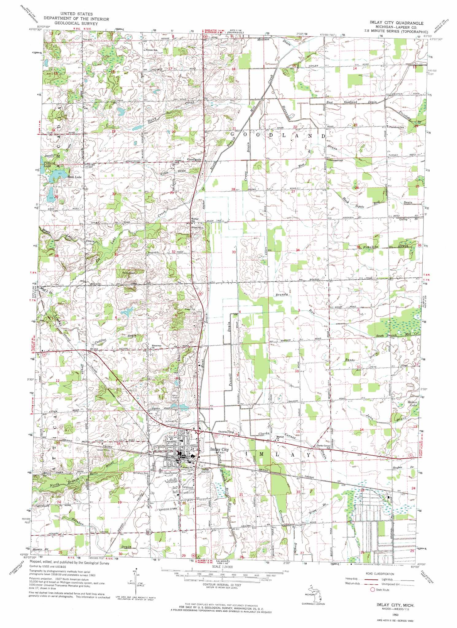
USGS Topo Quad 43083a1 - 1:24,000 scale
| Topo Map Name: | Imlay City |
| USGS Topo Quad ID: | 43083a1 |
| Print Size: | ca. 21 1/4" wide x 27" high |
| Southeast Coordinates: | 43° N latitude / 83° W longitude |
| Map Center Coordinates: | 43.0625° N latitude / 83.0625° W longitude |
| U.S. State: | MI |
| Filename: | o43083a1.jpg |
| Download Map JPG Image: | Imlay City topo map 1:24,000 scale |
| Map Type: | Topographic |
| Topo Series: | 7.5´ |
| Map Scale: | 1:24,000 |
| Source of Map Images: | United States Geological Survey (USGS) |
| Alternate Map Versions: |
Imlay City MI 1963, updated 1964 Download PDF Buy paper map Imlay City MI 1963, updated 1964 Download PDF Buy paper map Imlay City MI 2011 Download PDF Buy paper map Imlay City MI 2014 Download PDF Buy paper map Imlay City MI 2016 Download PDF Buy paper map |
1:24,000 Topo Quads surrounding Imlay City
Mayville |
Clifford |
Marlette |
Juhl |
Peck |
Barnes Lake |
North Branch |
Burnside |
Brown City |
Yale |
Lapeer |
Attica |
Imlay City |
Capac |
Brockway |
Metamora |
Thornville |
Almont |
Allenton |
Memphis |
Oxford |
Lake Orion |
Romeo |
Armada |
Richmond |
> Back to 43083a1 at 1:100,000 scale
> Back to 43082a1 at 1:250,000 scale
> Back to U.S. Topo Maps home
Imlay City topo map: Gazetteer
Imlay City: Canals
Anchor Drain elevation 245m 803′Brandy Run elevation 246m 807′
Bunde Drain elevation 246m 807′
Cadillac Drain elevation 265m 869′
Clarks Corner Drain elevation 247m 810′
Crowe Drain elevation 244m 800′
Devall Drain elevation 263m 862′
East Goodland Drain elevation 244m 800′
Hughes Drain elevation 250m 820′
Hunt Drain elevation 246m 807′
Jurn Drain elevation 244m 800′
Kruse Drain elevation 247m 810′
Lombar Drain elevation 259m 849′
Pennell Drain elevation 245m 803′
Stevenson Drain elevation 244m 800′
West Branch Stevenson Drain elevation 247m 810′
Wilkie Drain elevation 255m 836′
Imlay City: Lakes
Bass Lake elevation 261m 856′Pickerel Lake elevation 261m 856′
Imlay City: Parks
Grand Trunk Depot Historical Marker elevation 251m 823′Imlay City Historical Marker elevation 251m 823′
Kerney Park elevation 254m 833′
Lions Park elevation 249m 816′
Rotary Park elevation 248m 813′
Veteran's Park elevation 252m 826′
Imlay City: Populated Places
Goodland elevation 256m 839′Imlay City elevation 252m 826′
Maple Grove Mobile Home Communities elevation 255m 836′
Imlay City: Post Offices
Goodland Post Office (historical) elevation 256m 839′Imlay City Post Office elevation 252m 826′
Imlay Post Office (historical) elevation 275m 902′
Imlay City: Streams
Elk Lake Creek elevation 246m 807′Stony Creek elevation 244m 800′
Imlay City digital topo map on disk
Buy this Imlay City topo map showing relief, roads, GPS coordinates and other geographical features, as a high-resolution digital map file on DVD:
 map DVD")