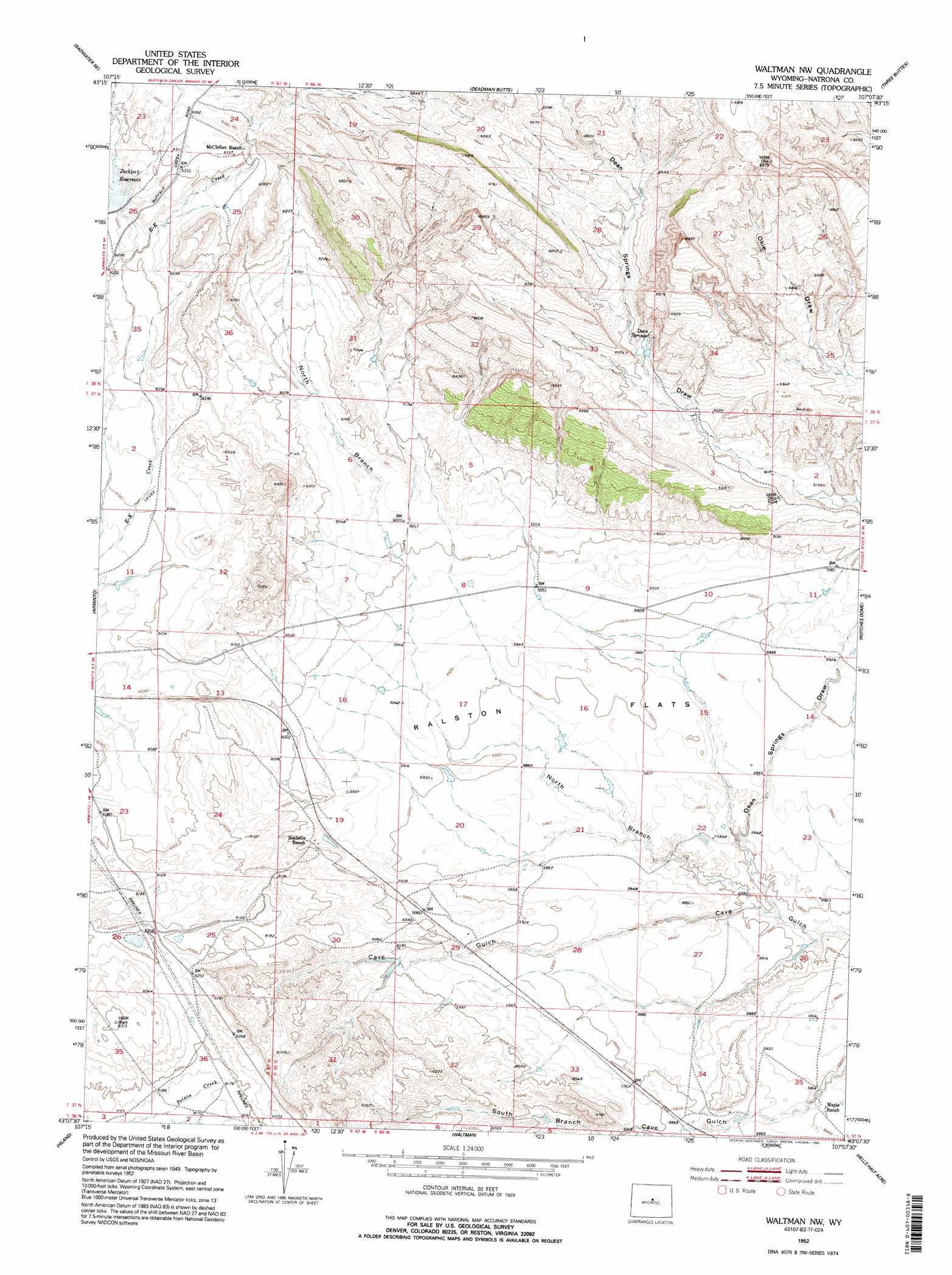
Waltman Nw Topo Map Wyoming
To zoom in, hover over the map of Waltman Nw
USGS Topo Quad 43107b2 - 1:24,000 scale
| Topo Map Name: | Waltman Nw |
| USGS Topo Quad ID: | 43107b2 |
| Print Size: | ca. 21 1/4" wide x 27" high |
| Southeast Coordinates: | 43.125° N latitude / 107.125° W longitude |
| Map Center Coordinates: | 43.1875° N latitude / 107.1875° W longitude |
| U.S. State: | WY |
| Filename: | o43107b2.jpg |
| Download Map JPG Image: | Waltman Nw topo map 1:24,000 scale |
| Map Type: | Topographic |
| Topo Series: | 7.5´ |
| Map Scale: | 1:24,000 |
| Source of Map Images: | United States Geological Survey (USGS) |
| Alternate Map Versions: |
Waltman NW WY 1952, updated 1953 Download PDF Buy paper map Waltman NW WY 1952, updated 1995 Download PDF Buy paper map Waltman NW WY 2012 Download PDF Buy paper map Waltman NW WY 2015 Download PDF Buy paper map |
1:24,000 Topo Quads surrounding Waltman Nw
Sioux Pass |
Badwater Ne |
Grave Spring |
First Water Draw |
Roughlock Hill |
Badwater |
Badwater Se |
Deadman Butte |
Three Buttes |
Flat Top Hill |
Arminto Nw |
Arminto |
Waltman Nw |
Notches Dome |
Cave Gulch Reservoir |
Arminto Sw |
Hiland |
Waltman |
Hells Half Acre |
Powder River |
Ervay Basin |
Mcrae Gap |
Broad Mesa |
Gaylord Reservoir |
Square Top Butte |
> Back to 43107a1 at 1:100,000 scale
> Back to 43106a1 at 1:250,000 scale
> Back to U.S. Topo Maps home
Waltman Nw topo map: Gazetteer
Waltman Nw: Dams
Dean Springs Dam elevation 1959m 6427′Dry Hole Dam elevation 1969m 6459′
Jack Pot Dam elevation 1897m 6223′
Rochelle Dam elevation 1807m 5928′
Rochelle Dam elevation 1839m 6033′
Waltman Nw: Flats
Ralston Flats elevation 1796m 5892′Waltman Nw: Reservoirs
Dean Springs Reservoir elevation 1959m 6427′Dry Hole Reservoir elevation 1969m 6459′
Jack Post Reservoir elevation 1897m 6223′
Rochelle Reservoir elevation 1807m 5928′
Rochelle Reservoir elevation 1839m 6033′
Waltman Nw: Springs
Dean Springs elevation 1930m 6332′Waltman Nw: Valleys
Dean Springs Draw elevation 1762m 5780′North Branch Cave Gulch elevation 1763m 5784′
Waltman Nw digital topo map on disk
Buy this Waltman Nw topo map showing relief, roads, GPS coordinates and other geographical features, as a high-resolution digital map file on DVD:
Eastern Wyoming & Western South Dakota
Buy digital topo maps: Eastern Wyoming & Western South Dakota