Alpine Topo Map Idaho
To zoom in, hover over the map of Alpine
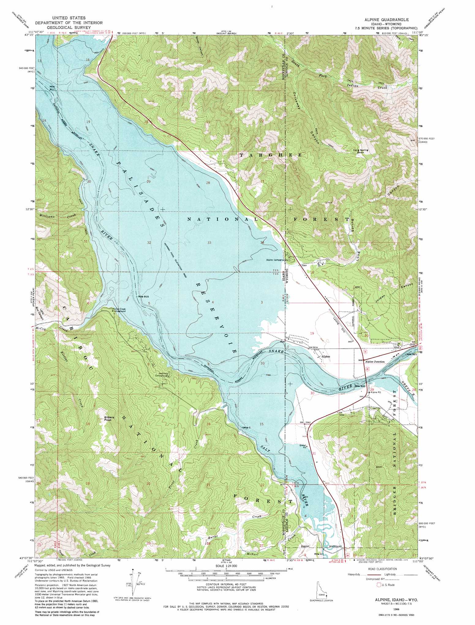
USGS Topo Quad 43111b1 - 1:24,000 scale
| Topo Map Name: | Alpine |
| USGS Topo Quad ID: | 43111b1 |
| Print Size: | ca. 21 1/4" wide x 27" high |
| Southeast Coordinates: | 43.125° N latitude / 111° W longitude |
| Map Center Coordinates: | 43.1875° N latitude / 111.0625° W longitude |
| U.S. States: | ID, WY |
| Filename: | o43111b1.jpg |
| Download Map JPG Image: | Alpine topo map 1:24,000 scale |
| Map Type: | Topographic |
| Topo Series: | 7.5´ |
| Map Scale: | 1:24,000 |
| Source of Map Images: | United States Geological Survey (USGS) |
| Alternate Map Versions: |
Alpine WY 1966, updated 1969 Download PDF Buy paper map Alpine WY 1966, updated 1979 Download PDF Buy paper map Alpine WY 1966, updated 1998 Download PDF Buy paper map Alpine WY 1966, updated 1998 Download PDF Buy paper map Alpine WY 2011 Download PDF Buy paper map Alpine WY 2015 Download PDF Buy paper map |
| FStopo: | US Forest Service topo Alpine is available: Download FStopo PDF Download FStopo TIF |
1:24,000 Topo Quads surrounding Alpine
Swan Valley |
Thompson Peak |
Palisades Peak |
Teton Pass |
Jackson |
Red Ridge |
Palisades Dam |
Mount Baird |
Observation Peak |
Munger Mountain |
Big Elk Mountain |
Poker Peak |
Alpine |
Ferry Peak |
Pine Creek |
Caribou Mountain |
Tincup Mountain |
Etna |
Stewart Peak |
Deer Creek |
Wayan East |
Stump Peak |
Thayne West |
Thayne East |
Man Peak |
> Back to 43111a1 at 1:100,000 scale
> Back to 43110a1 at 1:250,000 scale
> Back to U.S. Topo Maps home
Alpine topo map: Gazetteer
Alpine: Airports
Alpine Airport elevation 1715m 5626′Alpine: Basins
Long Spring Basin elevation 2254m 7395′Alpine: Mines
Spencer Call Sand and Gravel Pit elevation 1719m 5639′Alpine: Populated Places
Alpine elevation 1725m 5659′Alpine Junction elevation 1725m 5659′
Alpine: Post Offices
Alpine Post Office (historical) elevation 1717m 5633′Alpine: Springs
Alpine Hot Springs elevation 1714m 5623′Alpine: Streams
Bitters Creek elevation 1730m 5675′Burns Creek elevation 1714m 5623′
Greys River elevation 1719m 5639′
Indian Creek elevation 1714m 5623′
McCoy Creek elevation 1714m 5623′
McNeel Creek elevation 1714m 5623′
McNeel Creek elevation 1714m 5623′
North Fork Trout Creek elevation 1962m 6437′
Salt River elevation 1714m 5623′
Salt River elevation 1714m 5623′
Spring Run elevation 1714m 5623′
Trout Creek elevation 1715m 5626′
Williams Creek elevation 1716m 5629′
Alpine: Summits
Bitters Peak elevation 2189m 7181′Alpine: Valleys
Driveway Canyon elevation 1861m 6105′Grand Canyon elevation 1719m 5639′
Grand Valley elevation 1714m 5623′
Jordan Canyon elevation 1732m 5682′
Little Box Canyon elevation 1741m 5711′
Long Spring Canyon elevation 1717m 5633′
Alpine digital topo map on disk
Buy this Alpine topo map showing relief, roads, GPS coordinates and other geographical features, as a high-resolution digital map file on DVD: