Lucky Peak Topo Map Idaho
To zoom in, hover over the map of Lucky Peak
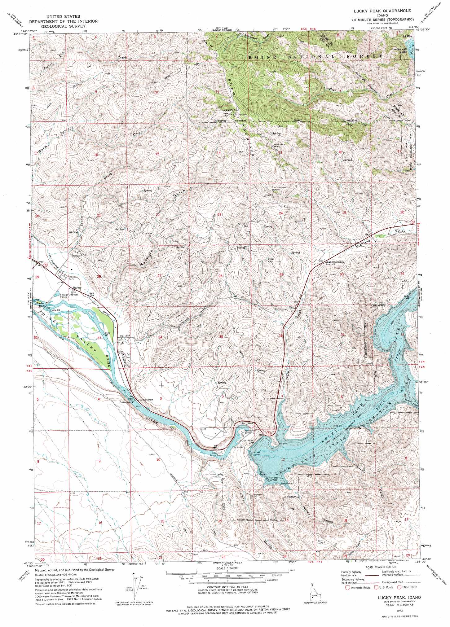
USGS Topo Quad 43116e1 - 1:24,000 scale
| Topo Map Name: | Lucky Peak |
| USGS Topo Quad ID: | 43116e1 |
| Print Size: | ca. 21 1/4" wide x 27" high |
| Southeast Coordinates: | 43.5° N latitude / 116° W longitude |
| Map Center Coordinates: | 43.5625° N latitude / 116.0625° W longitude |
| U.S. State: | ID |
| Filename: | o43116e1.jpg |
| Download Map JPG Image: | Lucky Peak topo map 1:24,000 scale |
| Map Type: | Topographic |
| Topo Series: | 7.5´ |
| Map Scale: | 1:24,000 |
| Source of Map Images: | United States Geological Survey (USGS) |
| Alternate Map Versions: |
Lucky Peak ID 1972, updated 1975 Download PDF Buy paper map Lucky Peak ID 2011 Download PDF Buy paper map Lucky Peak ID 2013 Download PDF Buy paper map |
| FStopo: | US Forest Service topo Lucky Peak is available: Download FStopo PDF Download FStopo TIF |
1:24,000 Topo Quads surrounding Lucky Peak
Pearl |
Cartwright Canyon |
Shafer Butte |
Warm Springs Point |
Idaho City |
Eagle |
Boise North |
Robie Creek |
Dunnigan Creek |
Arrowrock Reservoir Ne |
Cloverdale |
Boise South |
Lucky Peak |
Arrowrock Dam |
Grape Mountain |
Mora |
Owyhee |
Indian Creek Reservoir |
Mayfield |
Braves Creek |
Coyote Butte |
Christmas Mountain |
Orchard |
Mayfield Sw |
Mayfield Se |
> Back to 43116e1 at 1:100,000 scale
> Back to 43116a1 at 1:250,000 scale
> Back to U.S. Topo Maps home
Lucky Peak topo map: Gazetteer
Lucky Peak: Beaches
Sandy Point Beach elevation 862m 2828′Lucky Peak: Canals
Penitentiary Canal elevation 860m 2821′Lucky Peak: Dams
Barber Dam elevation 844m 2769′Boise Diversion Dam elevation 862m 2828′
Lucky Peak Dam elevation 933m 3061′
Lucky Peak: Mines
Adelmann Mine elevation 1531m 5022′Black Hornet Mine elevation 1426m 4678′
Queen Mine elevation 1234m 4048′
Lucky Peak: Parks
Barclay Bay Picnic Area elevation 941m 3087′Discovery Picnic Area elevation 860m 2821′
Lucky Peak State Recreation Area elevation 950m 3116′
Lucky Peak: Populated Places
Barber elevation 852m 2795′Lucky Peak: Reservoirs
Lucky Peak Lake elevation 933m 3061′Lucky Peak: Streams
Charcoal Creek elevation 934m 3064′Council Spring Creek elevation 856m 2808′
Sheep Creek elevation 936m 3070′
Lucky Peak: Summits
Highland Valley Summit elevation 1155m 3789′Lucky Peak elevation 1797m 5895′
Shaw Mountain elevation 1797m 5895′
Lucky Peak: Valleys
Lydle Gulch elevation 867m 2844′Maynard Gulch elevation 888m 2913′
Pipeline Gulch elevation 955m 3133′
Turner Gulch elevation 936m 3070′
Lucky Peak digital topo map on disk
Buy this Lucky Peak topo map showing relief, roads, GPS coordinates and other geographical features, as a high-resolution digital map file on DVD: