Lake Lowell Topo Map Idaho
To zoom in, hover over the map of Lake Lowell
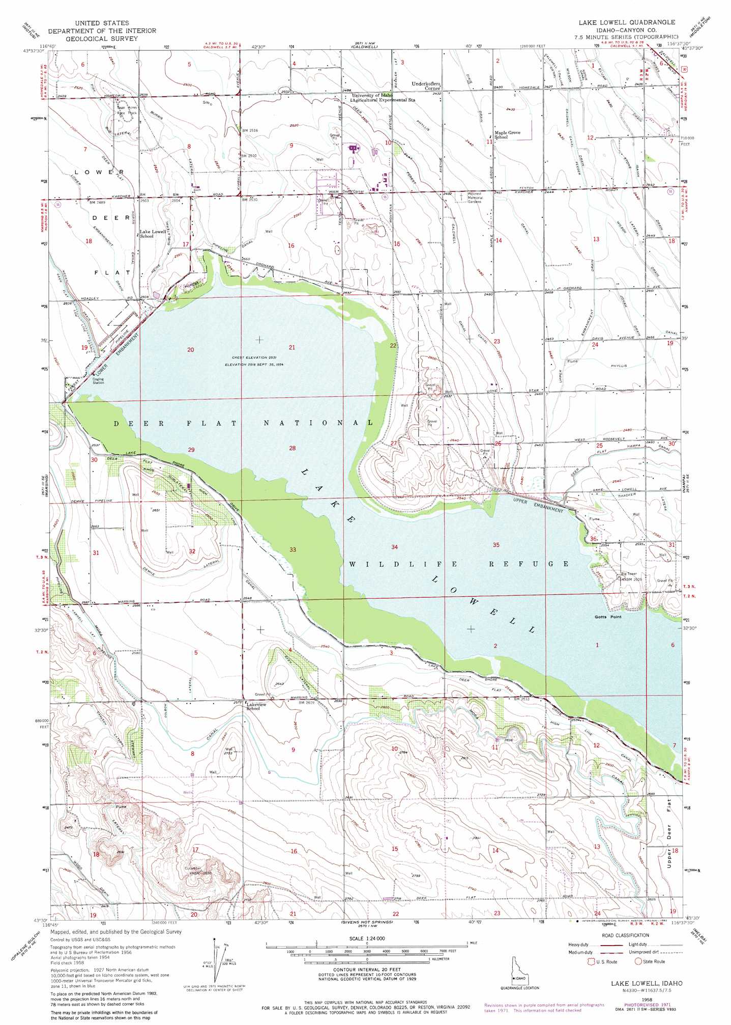
USGS Topo Quad 43116e6 - 1:24,000 scale
| Topo Map Name: | Lake Lowell |
| USGS Topo Quad ID: | 43116e6 |
| Print Size: | ca. 21 1/4" wide x 27" high |
| Southeast Coordinates: | 43.5° N latitude / 116.625° W longitude |
| Map Center Coordinates: | 43.5625° N latitude / 116.6875° W longitude |
| U.S. State: | ID |
| Filename: | o43116e6.jpg |
| Download Map JPG Image: | Lake Lowell topo map 1:24,000 scale |
| Map Type: | Topographic |
| Topo Series: | 7.5´ |
| Map Scale: | 1:24,000 |
| Source of Map Images: | United States Geological Survey (USGS) |
| Alternate Map Versions: |
Lake Lowell ID 1958, updated 1959 Download PDF Buy paper map Lake Lowell ID 1958, updated 1972 Download PDF Buy paper map Lake Lowell ID 1958, updated 1982 Download PDF Buy paper map Lake Lowell ID 2011 Download PDF Buy paper map Lake Lowell ID 2013 Download PDF Buy paper map |
1:24,000 Topo Quads surrounding Lake Lowell
Parma |
Parma Se |
Sand Hollow |
Southwest Emmett |
Southeast Emmett |
Wilder |
Notus |
Caldwell |
Middleton |
Star |
Homedale |
Marsing |
Lake Lowell |
Nampa |
Meridian |
Jump Creek Canyon |
Opalene Gulch |
Givens Hot Springs |
Melba |
Kuna |
Piute Butte |
Soldier Cap |
Wilson Peak |
Walters Butte |
Initial Point |
> Back to 43116e1 at 1:100,000 scale
> Back to 43116a1 at 1:250,000 scale
> Back to U.S. Topo Maps home
Lake Lowell topo map: Gazetteer
Lake Lowell: Canals
Aven Lateral elevation 799m 2621′Burris Lateral elevation 774m 2539′
Caldwell Canal Feeder elevation 739m 2424′
Carlson Lateral elevation 775m 2542′
Deer Flat Caldwell Canal elevation 761m 2496′
Deer Flat High Line Canal elevation 775m 2542′
Deer Flat Nampa Canal elevation 763m 2503′
Demke Lateral elevation 786m 2578′
Dolbow Lateral elevation 792m 2598′
Fenton Lateral elevation 745m 2444′
Forest Canal elevation 768m 2519′
Heine Sublateral elevation 776m 2545′
Isaiah Drain elevation 745m 2444′
Knob Sublateral elevation 786m 2578′
Messler Lateral elevation 743m 2437′
Moses Drain elevation 742m 2434′
Stewart Lateral elevation 806m 2644′
Stone Lateral elevation 745m 2444′
Thacker Lateral elevation 779m 2555′
Wilson Drain elevation 745m 2444′
Wood Drain elevation 734m 2408′
Lake Lowell: Capes
Gotts Point elevation 768m 2519′Lake Lowell: Dams
Deer Flat-Lower Dam elevation 763m 2503′Deer Flat-Middle Dam elevation 775m 2542′
Deer Flat-Upper Dam elevation 768m 2519′
Lake Lowell: Populated Places
Underkoflers Corner elevation 742m 2434′Lake Lowell: Reservoirs
Lake Lowell elevation 763m 2503′Lake Lowell: Streams
Jonah Drain elevation 745m 2444′Upper Embankment Drain elevation 746m 2447′
Lake Lowell digital topo map on disk
Buy this Lake Lowell topo map showing relief, roads, GPS coordinates and other geographical features, as a high-resolution digital map file on DVD: