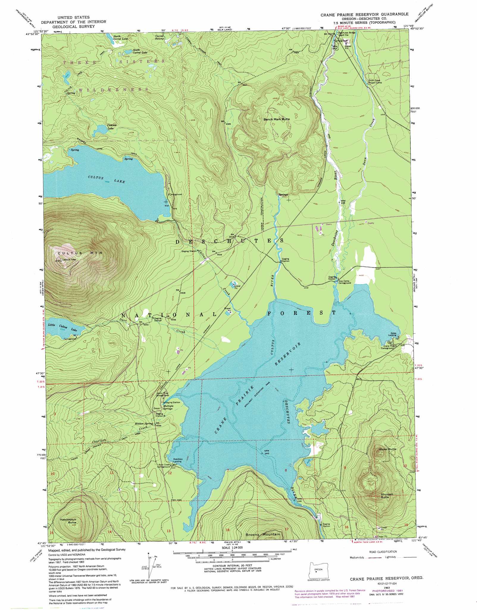
Crane Prairie Reservoir Topo Map Oregon
To zoom in, hover over the map of Crane Prairie Reservoir
USGS Topo Quad 43121g7 - 1:24,000 scale
| Topo Map Name: | Crane Prairie Reservoir |
| USGS Topo Quad ID: | 43121g7 |
| Print Size: | ca. 21 1/4" wide x 27" high |
| Southeast Coordinates: | 43.75° N latitude / 121.75° W longitude |
| Map Center Coordinates: | 43.8125° N latitude / 121.8125° W longitude |
| U.S. State: | OR |
| Filename: | o43121g7.jpg |
| Download Map JPG Image: | Crane Prairie Reservoir topo map 1:24,000 scale |
| Map Type: | Topographic |
| Topo Series: | 7.5´ |
| Map Scale: | 1:24,000 |
| Source of Map Images: | United States Geological Survey (USGS) |
| Alternate Map Versions: |
Crane Prairie Reservoir OR 1963, updated 1965 Download PDF Buy paper map Crane Prairie Reservoir OR 1963, updated 1981 Download PDF Buy paper map Crane Prairie Reservoir OR 1963, updated 1981 Download PDF Buy paper map Crane Prairie Reservoir OR 1963, updated 1992 Download PDF Buy paper map Crane Prairie Reservoir OR 2011 Download PDF Buy paper map Crane Prairie Reservoir OR 2014 Download PDF Buy paper map |
| FStopo: | US Forest Service topo Crane Prairie Reservoir is available: Download FStopo PDF Download FStopo TIF |
1:24,000 Topo Quads surrounding Crane Prairie Reservoir
French Mountain |
Substitute Point |
South Sister |
Lake Geneva |
Tumalo Falls |
Chucksney Mountain |
Packsaddle Mountain |
Elk Lake |
Bachelor Butte |
Wanoga Butte |
Waldo Mountain |
Irish Mountain |
Crane Prairie Reservoir |
Round Mountain |
Pistol Butte |
Waldo Lake |
The Twins |
Davis Mountain |
Wickiup Dam |
La Pine |
Willamette Pass |
Odell Lake |
Hamner Butte |
Cryder Butte |
Masten Butte |
> Back to 43121e1 at 1:100,000 scale
> Back to 43120a1 at 1:250,000 scale
> Back to U.S. Topo Maps home
Crane Prairie Reservoir topo map: Gazetteer
Crane Prairie Reservoir: Areas
Crane Prairie elevation 1373m 4504′Crane Prairie Reservoir: Dams
Crane Prairie Dam elevation 1376m 4514′Crane Prairie Reservoir: Lakes
Comma Lake elevation 1451m 4760′Cultus Lake elevation 1424m 4671′
Little Cultus Lake elevation 1452m 4763′
North Corral Lake elevation 1561m 5121′
South Corral Lake elevation 1562m 5124′
Crane Prairie Reservoir: Reservoirs
Crane Prairie Reservoir elevation 1357m 4452′Crane Prairie Reservoir: Springs
Hidden Spring elevation 1369m 4491′Multiple Springs elevation 1357m 4452′
Crane Prairie Reservoir: Streams
Charlton Creek elevation 1356m 4448′Cultus Creek elevation 1356m 4448′
Cultus River elevation 1356m 4448′
Deer Creek elevation 1356m 4448′
Snow Creek elevation 1356m 4448′
Crane Prairie Reservoir: Summits
Bench Mark Butte elevation 1530m 5019′Cultus Mountain elevation 2058m 6751′
Ketchketch Butte elevation 1643m 5390′
Palanush Butte elevation 1509m 4950′
Shukash Butte elevation 1593m 5226′
Wuksi Butte elevation 1568m 5144′
Crane Prairie Reservoir: Swamps
Corral Swamp elevation 1525m 5003′Crane Prairie Reservoir: Trails
Corral Swamp Trail elevation 1496m 4908′Cultus Lake Trail elevation 1541m 5055′
Twins Crane Prairie Trail elevation 1442m 4730′
Crane Prairie Reservoir digital topo map on disk
Buy this Crane Prairie Reservoir topo map showing relief, roads, GPS coordinates and other geographical features, as a high-resolution digital map file on DVD: