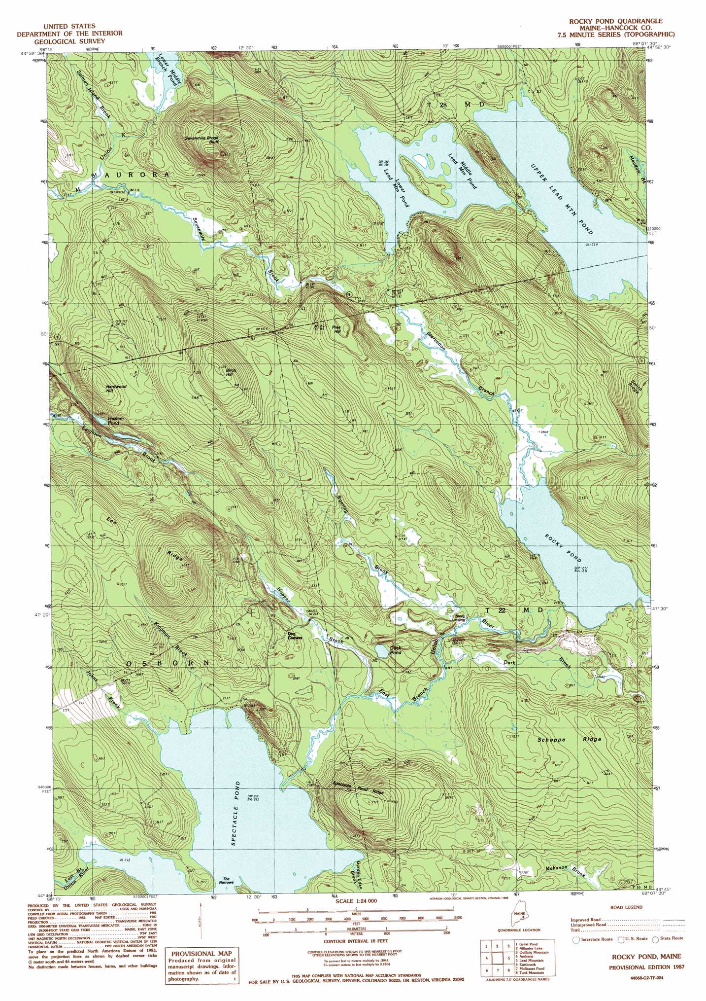
Rocky Pond Topo Map Maine
To zoom in, hover over the map of Rocky Pond
USGS Topo Quad 44068g2 - 1:24,000 scale
| Topo Map Name: | Rocky Pond |
| USGS Topo Quad ID: | 44068g2 |
| Print Size: | ca. 21 1/4" wide x 27" high |
| Southeast Coordinates: | 44.75° N latitude / 68.125° W longitude |
| Map Center Coordinates: | 44.8125° N latitude / 68.1875° W longitude |
| U.S. State: | ME |
| Filename: | o44068g2.jpg |
| Download Map JPG Image: | Rocky Pond topo map 1:24,000 scale |
| Map Type: | Topographic |
| Topo Series: | 7.5´ |
| Map Scale: | 1:24,000 |
| Source of Map Images: | United States Geological Survey (USGS) |
| Alternate Map Versions: |
Rocky Pond ME 1987, updated 1988 Download PDF Buy paper map Rocky Pond ME 2011 Download PDF Buy paper map Rocky Pond ME 2014 Download PDF Buy paper map |
1:24,000 Topo Quads surrounding Rocky Pond
Greenfield |
Brandy Pond |
West Lake |
Gassabias Lake |
Fletcher Peak |
The Horseback |
Great Pond |
Alligator Lake |
Quillpig Mountain |
Peaked Mountain |
Hopkins Pond |
Amherst |
Rocky Pond |
Lead Mountain |
Northeast Bluff |
Beech Hill Pond |
Eastbrook |
Molasses Pond |
Tunk Mountain |
Schoodic Lake |
Ellsworth |
Hancock |
Sullivan |
Tunk Lake |
Cherryfield |
> Back to 44068e1 at 1:100,000 scale
> Back to 44068a1 at 1:250,000 scale
> Back to U.S. Topo Maps home
Rocky Pond topo map: Gazetteer
Rocky Pond: Channels
The Narrows elevation 77m 252′Rocky Pond: Cliffs
Sevenmile Brook Bluff elevation 193m 633′Rocky Pond: Dams
Leighton River Dam elevation 86m 282′Lower Lead Mountain Dam elevation 103m 337′
Upper Lead Mountain Dam elevation 108m 354′
Rocky Pond: Lakes
Duck Pond elevation 83m 272′Hazlam Pond elevation 88m 288′
Middle Lead Mountain Pond elevation 103m 337′
Rocky Pond elevation 84m 275′
Spectacle Pond elevation 77m 252′
Rocky Pond: Populated Places
Dog Corners elevation 92m 301′Steep Landing elevation 81m 265′
Rocky Pond: Reservoirs
Leighton River Reservoir elevation 86m 282′Lower Lead Mountain Pond elevation 103m 337′
Upper Lead Mountain Pond elevation 108m 354′
Rocky Pond: Ridges
Een Ridge elevation 174m 570′Schoppe Ridge elevation 127m 416′
Spectacle Pond Ridge elevation 164m 538′
Rocky Pond: Streams
Dark Brook elevation 83m 272′Garden Eden Brook elevation 79m 259′
Hopper Brook elevation 80m 262′
Johns Brook elevation 77m 252′
Kingman Brook elevation 77m 252′
Roaring Brook elevation 81m 265′
Salmon Island Brook elevation 87m 285′
Sevenmile Brook elevation 82m 269′
Starvation Branch elevation 84m 275′
Rocky Pond: Summits
Birch Hill elevation 198m 649′Hardwood Hill elevation 149m 488′
Pine Hill elevation 149m 488′
Rocky Pond digital topo map on disk
Buy this Rocky Pond topo map showing relief, roads, GPS coordinates and other geographical features, as a high-resolution digital map file on DVD:
Maine, New Hampshire, Rhode Island & Eastern Massachusetts
Buy digital topo maps: Maine, New Hampshire, Rhode Island & Eastern Massachusetts