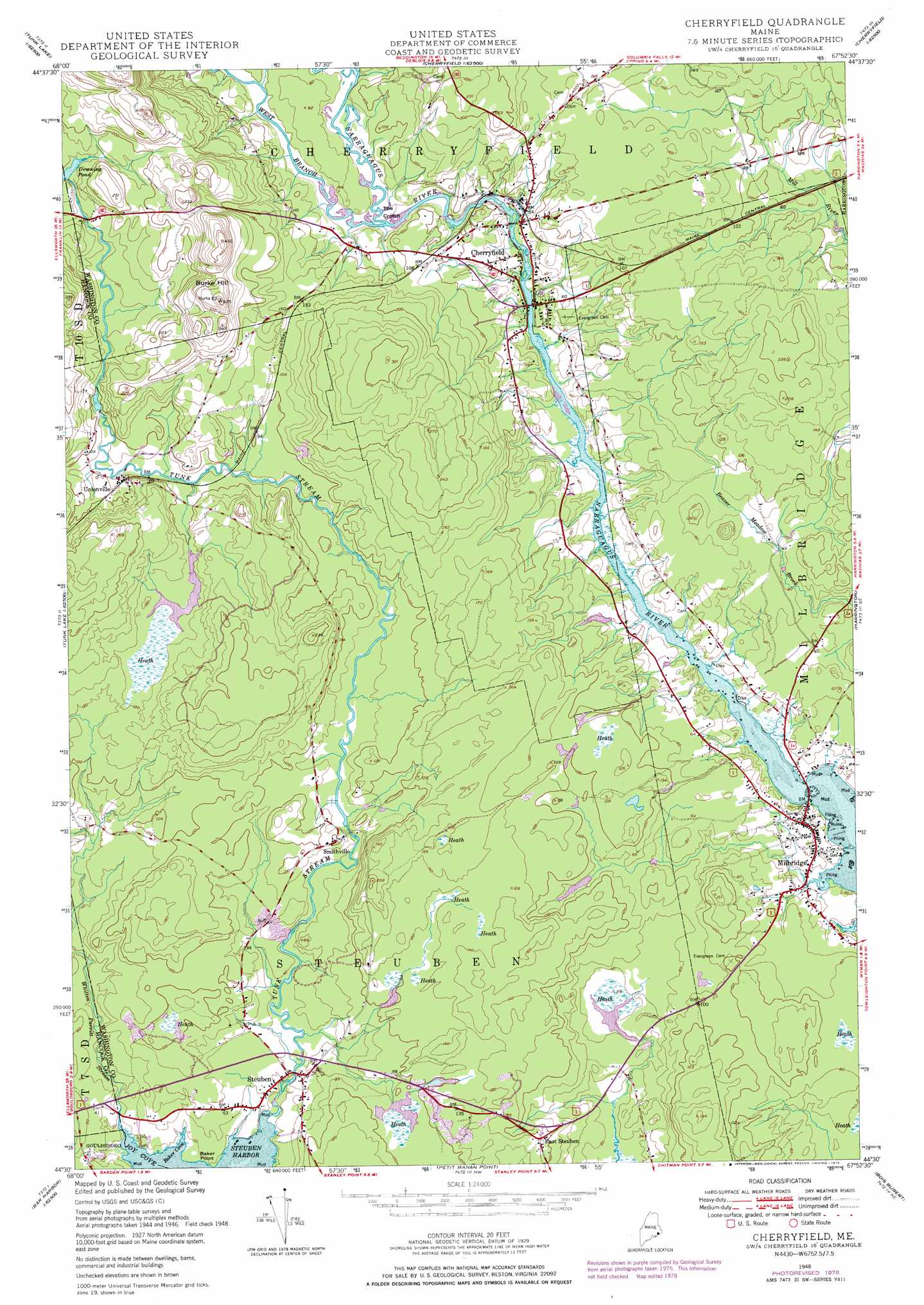
Cherryfield Topo Map Maine
To zoom in, hover over the map of Cherryfield
USGS Topo Quad 44067e8 - 1:24,000 scale
| Topo Map Name: | Cherryfield |
| USGS Topo Quad ID: | 44067e8 |
| Print Size: | ca. 21 1/4" wide x 27" high |
| Southeast Coordinates: | 44.5° N latitude / 67.875° W longitude |
| Map Center Coordinates: | 44.5625° N latitude / 67.9375° W longitude |
| U.S. State: | ME |
| Filename: | o44067e8.jpg |
| Download Map JPG Image: | Cherryfield topo map 1:24,000 scale |
| Map Type: | Topographic |
| Topo Series: | 7.5´ |
| Map Scale: | 1:24,000 |
| Source of Map Images: | United States Geological Survey (USGS) |
| Alternate Map Versions: |
Cherryfield ME 1948, updated 1978 Download PDF Buy paper map Cherryfield ME 1950 Download PDF Buy paper map Cherryfield ME 2011 Download PDF Buy paper map Cherryfield ME 2014 Download PDF Buy paper map |
1:24,000 Topo Quads surrounding Cherryfield
Rocky Pond |
Lead Mountain |
Northeast Bluff |
Montegail Pond |
Peaked Mountain Pond |
Molasses Pond |
Tunk Mountain |
Schoodic Lake |
Epping |
Columbia Falls |
Sullivan |
Tunk Lake |
Cherryfield |
Harrington |
Addison |
Bar Harbor |
Winter Harbor |
Petit Manan Point |
Bois Bubert |
Drisko Island |
Seal Harbor |
Schoodic Head |
> Back to 44067e1 at 1:100,000 scale
> Back to 44066a1 at 1:250,000 scale
> Back to U.S. Topo Maps home
Cherryfield topo map: Gazetteer
Cherryfield: Airports
Milbridge Heliport elevation 13m 42′Narraguagus Airport (historical) elevation 24m 78′
Cherryfield: Bays
Baker Cove elevation 0m 0′Steuben Harbor elevation 0m 0′
Cherryfield: Capes
Baker Point elevation 5m 16′The Crotch elevation 16m 52′
Cherryfield: Dams
Cherryfield Dam elevation 13m 42′East Steuben Dam elevation 12m 39′
Cherryfield: Parks
Cherryfield Historic District elevation 3m 9′Cherryfield: Populated Places
Cherryfield elevation 18m 59′East Steuben elevation 37m 121′
Milbridge elevation 10m 32′
Smithville elevation 32m 104′
Steuben elevation 12m 39′
Unionville elevation 25m 82′
Cherryfield: Reservoirs
East Steuben Pond elevation 12m 39′Narraguagus River Reservoir elevation 18m 59′
Cherryfield: Streams
Mahanon Branch elevation 17m 55′Tunk Stream elevation 1m 3′
West Branch Narraguagus River elevation 15m 49′
Whitten Parritt Stream elevation 0m 0′
Cherryfield: Summits
Burke Hill elevation 120m 393′Cherryfield digital topo map on disk
Buy this Cherryfield topo map showing relief, roads, GPS coordinates and other geographical features, as a high-resolution digital map file on DVD:
Maine, New Hampshire, Rhode Island & Eastern Massachusetts
Buy digital topo maps: Maine, New Hampshire, Rhode Island & Eastern Massachusetts