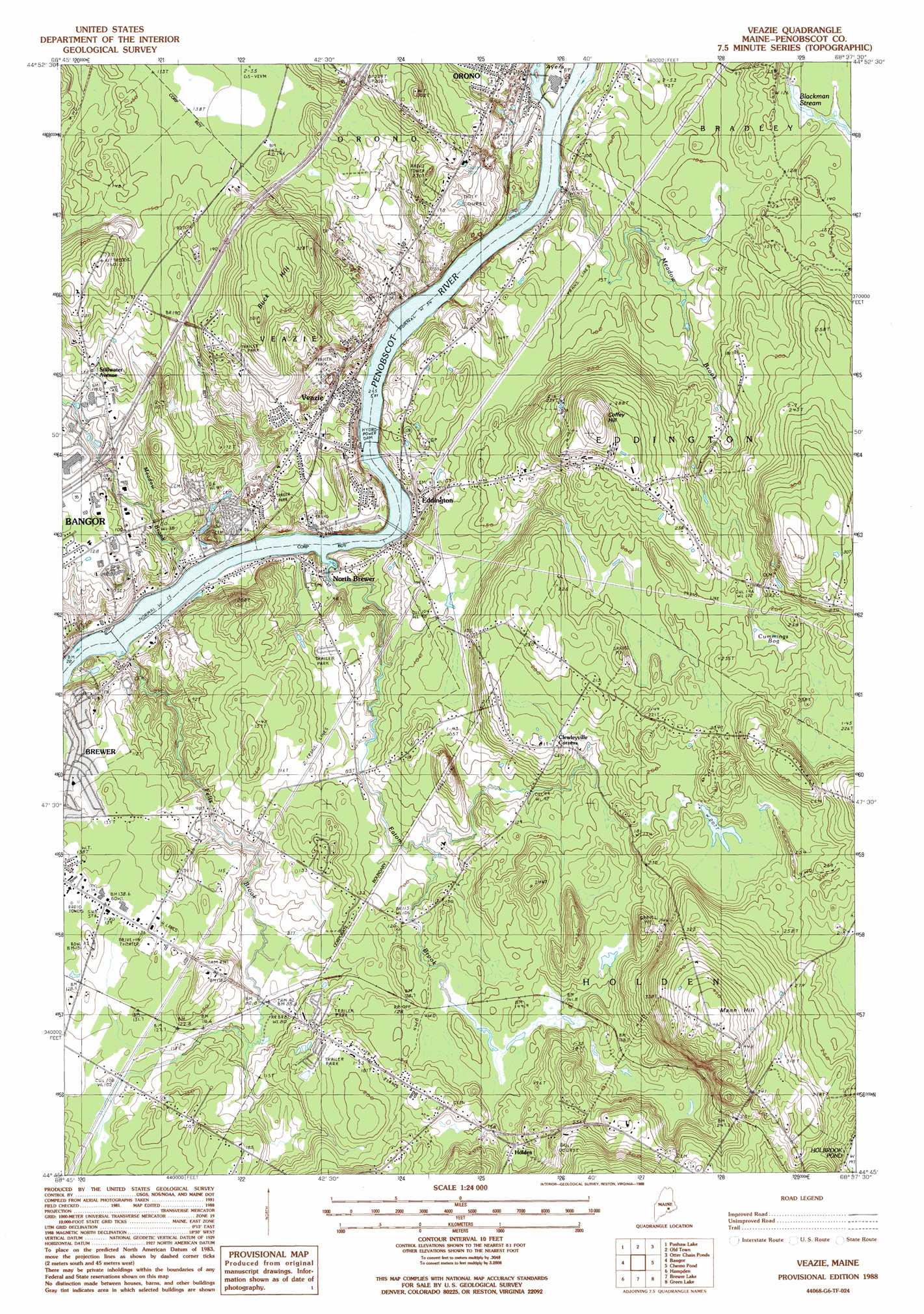
Veazie Topo Map Maine
To zoom in, hover over the map of Veazie
USGS Topo Quad 44068g6 - 1:24,000 scale
| Topo Map Name: | Veazie |
| USGS Topo Quad ID: | 44068g6 |
| Print Size: | ca. 21 1/4" wide x 27" high |
| Southeast Coordinates: | 44.75° N latitude / 68.625° W longitude |
| Map Center Coordinates: | 44.8125° N latitude / 68.6875° W longitude |
| U.S. State: | ME |
| Filename: | o44068g6.jpg |
| Download Map JPG Image: | Veazie topo map 1:24,000 scale |
| Map Type: | Topographic |
| Topo Series: | 7.5´ |
| Map Scale: | 1:24,000 |
| Source of Map Images: | United States Geological Survey (USGS) |
| Alternate Map Versions: |
Veazie ME 1988, updated 1988 Download PDF Buy paper map Veazie ME 1988, updated 1988 Download PDF Buy paper map Veazie ME 2011 Download PDF Buy paper map Veazie ME 2014 Download PDF Buy paper map |
1:24,000 Topo Quads surrounding Veazie
Bradford |
South Lagrange |
Greenbush |
Olamon |
Greenfield |
Kenduskeag |
Pushaw Lake |
Old Town |
Otter Chain Ponds |
The Horseback |
Hermon |
Bangor |
Veazie |
Chemo Pond |
Hopkins Pond |
Snow Mountain |
Hampden |
Brewer Lake |
Green Lake |
Beech Hill Pond |
Mount Waldo |
Bucksport |
Orland |
Branch Lake |
Ellsworth |
> Back to 44068e1 at 1:100,000 scale
> Back to 44068a1 at 1:250,000 scale
> Back to U.S. Topo Maps home
Veazie topo map: Gazetteer
Veazie: Crossings
Interchange 49 elevation 33m 108′Interchange 50 elevation 66m 216′
Veazie: Dams
Bangor Dam (historical) elevation 4m 13′Orono Waterworks Dam elevation 37m 121′
Veazie Dam elevation 10m 32′
Veazie: Forests
Penobscot Experimantal Forest elevation 48m 157′Veazie: Parks
Bangor Dam and Salmon Pool Park elevation 5m 16′Grotto Cascade Park elevation 7m 22′
Indian Trail Park elevation 16m 52′
Veazie: Populated Places
Basin Mills elevation 10m 32′Eddington elevation 22m 72′
Holden elevation 55m 180′
North Brewer elevation 19m 62′
Stillwater Avenue elevation 43m 141′
Veazie elevation 27m 88′
Veazie: Reservoirs
Blackman Stream elevation 37m 121′Penobscot River Reservoir elevation 10m 32′
Penobscot River Reservoir (historical) elevation 2m 6′
Veazie: Streams
Eaton Brook elevation 4m 13′Felts Brook elevation 2m 6′
Meadow Brook elevation 19m 62′
Meadow Brook elevation 14m 45′
Penjajawoc Stream elevation 4m 13′
Veazie: Summits
Buck Hill elevation 93m 305′Coffey Hill elevation 115m 377′
Mann Hill elevation 141m 462′
Veazie: Swamps
Cummings Bog elevation 57m 187′Veazie digital topo map on disk
Buy this Veazie topo map showing relief, roads, GPS coordinates and other geographical features, as a high-resolution digital map file on DVD:
Maine, New Hampshire, Rhode Island & Eastern Massachusetts
Buy digital topo maps: Maine, New Hampshire, Rhode Island & Eastern Massachusetts