Clintonville Topo Map New York
To zoom in, hover over the map of Clintonville
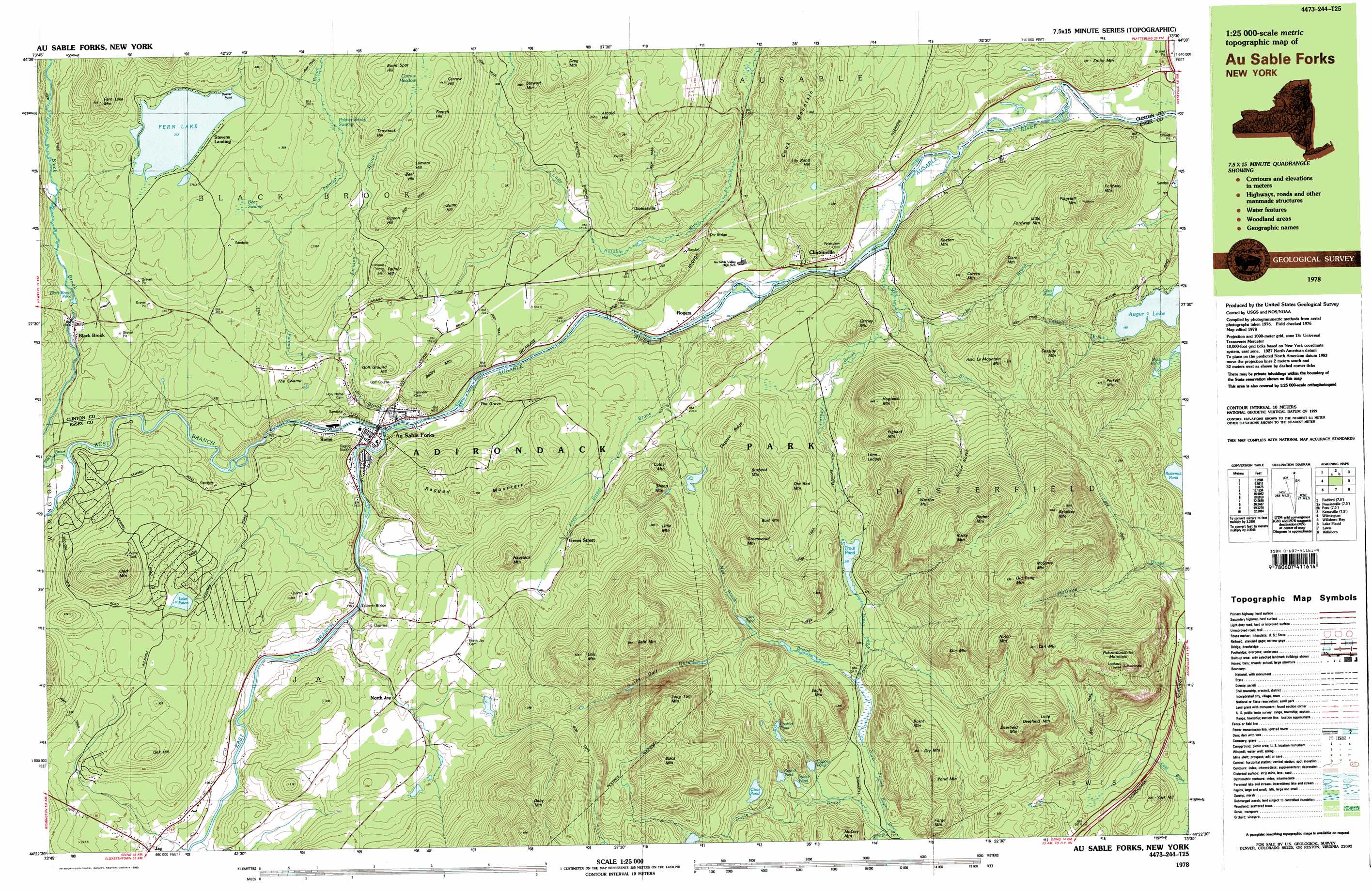
USGS Topo Quad 44073d5 - 1:25,000 scale
| Topo Map Name: | Clintonville |
| USGS Topo Quad ID: | 44073d5 |
| Print Size: | ca. 39" wide x 24" high |
| Southeast Coordinates: | 44.375° N latitude / 73.5° W longitude |
| Map Center Coordinates: | 44.4375° N latitude / 73.625° W longitude |
| U.S. State: | NY |
| Filename: | k44073d5.jpg |
| Download Map JPG Image: | Clintonville topo map 1:25,000 scale |
| Map Type: | Topographic |
| Topo Series: | 7.5´x15´ |
| Map Scale: | 1:25,000 |
| Source of Map Images: | United States Geological Survey (USGS) |
| Alternate Map Versions: |
Au Sable Forks NY 1978, updated 1979 Download PDF Buy paper map Au Sable Forks NY 1978, updated 1990 Download PDF Buy paper map Au Sable Forks NY 1978, updated 1990 Download PDF Buy paper map |
1:24,000 Topo Quads surrounding Clintonville
Moffitsville |
Dannemora |
Morrisonville |
Plattsburgh |
South Hero |
Redford |
Peasleeville |
Peru |
Keeseville |
Colchester Point |
Wilmington |
Clintonville |
Juniper Island |
||
Keene |
Lewis |
Charlotte |
||
Keene Valley |
Elizabethtown |
Vergennes West |
> Back to 44073a1 at 1:100,000 scale
> Back to 44072a1 at 1:250,000 scale
> Back to U.S. Topo Maps home
Clintonville topo map: Gazetteer
Clintonville: Airports
Catalano Airfield elevation 280m 918′Clintonville: Benches
Lime Ledges elevation 301m 987′Clintonville: Bridges
Dry Bridge elevation 200m 656′Stickney Bridge elevation 173m 567′
Clintonville: Capes
Beaver Point elevation 373m 1223′Picnic Point elevation 302m 990′
Clintonville: Flats
Carrow Meadow elevation 404m 1325′The Swamp elevation 251m 823′
Clintonville: Gaps
Noon Notch elevation 376m 1233′Clintonville: Lakes
Augur Lake elevation 168m 551′Black Brook Pond elevation 301m 987′
Clark Pond elevation 266m 872′
Clark Pond elevation 235m 770′
Clear Pond elevation 315m 1033′
Copper Pond elevation 225m 738′
Fern Lake elevation 373m 1223′
Lake Eaton elevation 295m 967′
Lockart Pond elevation 275m 902′
Mud Pond elevation 168m 551′
Nesbit Pond elevation 236m 774′
Round Pond elevation 256m 839′
Trout Pond elevation 262m 859′
Clintonville: Populated Places
Au Sable Forks elevation 168m 551′Black Brook elevation 297m 974′
Clintonville elevation 154m 505′
Green Street elevation 265m 869′
Jay elevation 216m 708′
North Jay elevation 236m 774′
Rogers elevation 151m 495′
Rome elevation 174m 570′
Stevens Landing elevation 376m 1233′
Thomasville elevation 207m 679′
Clintonville: Ridges
Gagnon Ridge elevation 336m 1102′Clintonville: Streams
Black Brook elevation 240m 787′Carney Brook elevation 135m 442′
Cassidy Brook elevation 168m 551′
Curren Brook elevation 149m 488′
Doyle Brook elevation 218m 715′
Durgan Brook elevation 228m 748′
East Branch Ausable River elevation 160m 524′
Gay Brook elevation 140m 459′
Green Street Brook elevation 140m 459′
Hale Brook elevation 217m 711′
Jackson Brook elevation 209m 685′
Mud Brook elevation 235m 770′
Palmer Brook elevation 161m 528′
Trout Pond Brook elevation 228m 748′
West Branch Ausable River elevation 160m 524′
Clintonville: Summits
Alec La Mountain Mountain elevation 362m 1187′Arnold Hill elevation 372m 1220′
Bailey Mountain elevation 293m 961′
Bald Mountain elevation 645m 2116′
Baldface Mountain elevation 673m 2208′
Barber Mountain elevation 634m 2080′
Bear Hill elevation 441m 1446′
Black Mountain elevation 649m 2129′
Burbank Mountain elevation 392m 1286′
Burnt Hill elevation 349m 1145′
Burnt Mountain elevation 466m 1528′
Burnt Spot Hill elevation 473m 1551′
Burt Mountain elevation 458m 1502′
Carl Mountain elevation 682m 2237′
Carney Mountain elevation 277m 908′
Carrow Hill elevation 440m 1443′
Cassidy Mountain elevation 332m 1089′
Clark Mountain elevation 351m 1151′
Clark Mountain elevation 477m 1564′
Colby Mountain elevation 334m 1095′
Cook Mountain elevation 336m 1102′
Curren Mountain elevation 364m 1194′
Daby Mountain elevation 623m 2043′
Deerfield Mountain elevation 637m 2089′
Drag Mountain elevation 399m 1309′
Dry Mountain elevation 491m 1610′
Eagle Mountain elevation 383m 1256′
Ellis Mountain elevation 556m 1824′
Fern Lake Mountain elevation 514m 1686′
Flagstaff Mountain elevation 420m 1377′
Fordway Mountain elevation 374m 1227′
Forge Mountain elevation 372m 1220′
French Hill elevation 435m 1427′
Golf Ground Hill elevation 280m 918′
Greenwood Mountain elevation 458m 1502′
Hamlin Mountain elevation 373m 1223′
Haystack Mountain elevation 430m 1410′
Hogback Mountain elevation 441m 1446′
Keeton Mountain elevation 334m 1095′
Kiln Mountain elevation 520m 1706′
Lamora Hill elevation 454m 1489′
Lily Pond Hill elevation 325m 1066′
Little Deerfield Mountain elevation 563m 1847′
Little Fordway Mountain elevation 348m 1141′
Little Mountain elevation 391m 1282′
Long Tom Mountain elevation 640m 2099′
McCray Mountain elevation 371m 1217′
McGuire Mountain elevation 664m 2178′
Notch Mountain elevation 632m 2073′
Oak Hill elevation 374m 1227′
Old Rang Mountain elevation 694m 2276′
Ore Bed Mountain elevation 324m 1062′
Palmer Hill elevation 352m 1154′
Perkett Mountain elevation 373m 1223′
Pigback Mountain elevation 414m 1358′
Pigeon Hill elevation 379m 1243′
Pokamoonshine Mountain elevation 659m 2162′
Pond Mountain elevation 442m 1450′
Ragged Mountain elevation 395m 1295′
Rocky Mountain elevation 665m 2181′
Sheep Mountain elevation 357m 1171′
Smith Mountain elevation 245m 803′
Tamarack Hill elevation 443m 1453′
Weston Mountain elevation 544m 1784′
York Hill elevation 324m 1062′
Clintonville: Swamps
Bear Swamp elevation 356m 1167′Palmer Brook Swamp elevation 357m 1171′
Clintonville: Valleys
The Gulf elevation 255m 836′Clintonville: Woods
The Grove elevation 219m 718′Clintonville digital topo map on disk
Buy this Clintonville topo map showing relief, roads, GPS coordinates and other geographical features, as a high-resolution digital map file on DVD:
New York, Vermont, Connecticut & Western Massachusetts
Buy digital topo maps: New York, Vermont, Connecticut & Western Massachusetts