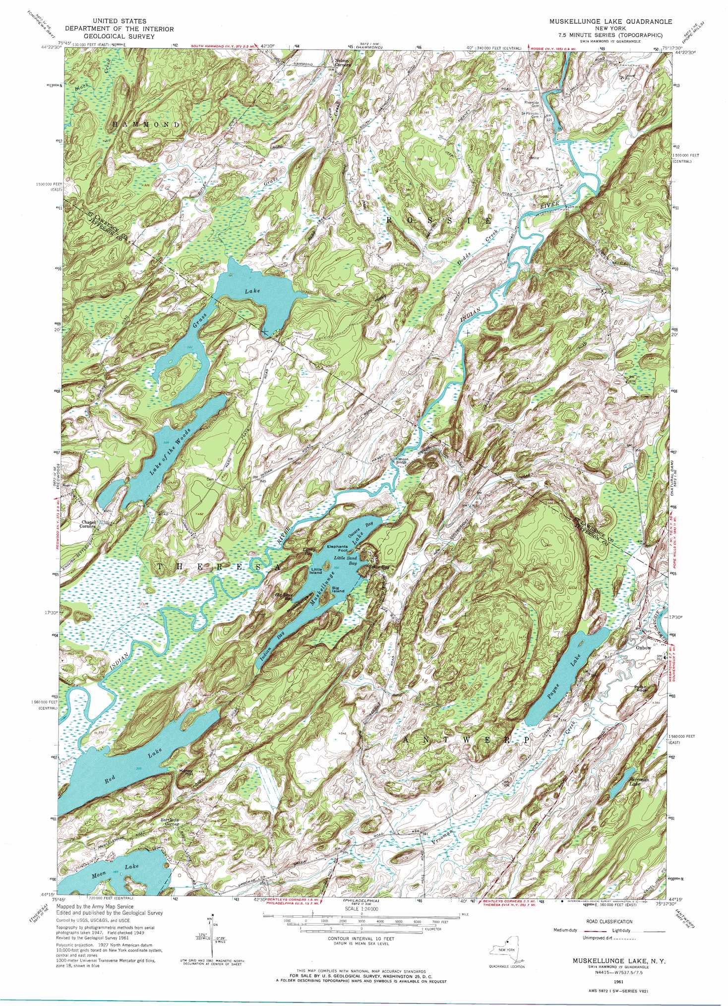
Muskellunge Lake Topo Map New York
To zoom in, hover over the map of Muskellunge Lake
USGS Topo Quad 44075c6 - 1:24,000 scale
| Topo Map Name: | Muskellunge Lake |
| USGS Topo Quad ID: | 44075c6 |
| Print Size: | ca. 21 1/4" wide x 27" high |
| Southeast Coordinates: | 44.25° N latitude / 75.625° W longitude |
| Map Center Coordinates: | 44.3125° N latitude / 75.6875° W longitude |
| U.S. State: | NY |
| Filename: | o44075c6.jpg |
| Download Map JPG Image: | Muskellunge Lake topo map 1:24,000 scale |
| Map Type: | Topographic |
| Topo Series: | 7.5´ |
| Map Scale: | 1:24,000 |
| Source of Map Images: | United States Geological Survey (USGS) |
| Alternate Map Versions: |
Muskalonge Lake NY 1951 Download PDF Buy paper map Muskellunge Lake NY 1961, updated 1964 Download PDF Buy paper map Muskellunge Lake NY 1961, updated 1964 Download PDF Buy paper map Muskellunge Lake NY 2010 Download PDF Buy paper map Muskellunge Lake NY 2013 Download PDF Buy paper map Muskellunge Lake NY 2016 Download PDF Buy paper map |
1:24,000 Topo Quads surrounding Muskellunge Lake
Morristown |
Edwardsville |
Heuvelton |
||
Chippewa Bay |
Hammond |
Pope Mills |
Richville |
|
Alexandria Bay |
Redwood |
Muskellunge Lake |
Natural Dam |
Gouverneur |
La Fargeville |
Theresa |
Philadelphia |
Antwerp |
Lake Bonaparte |
Brownville |
Black River |
Deferiet |
North Wilna |
Natural Bridge |
> Back to 44075a1 at 1:100,000 scale
> Back to 44074a1 at 1:250,000 scale
> Back to U.S. Topo Maps home
Muskellunge Lake topo map: Gazetteer
Muskellunge Lake: Bays
Big Bass Bay elevation 92m 301′Indian Bay elevation 92m 301′
Little Sand Bay elevation 92m 301′
Lucky Bay elevation 92m 301′
Oscars Bay elevation 92m 301′
Zekes Bay elevation 92m 301′
Muskellunge Lake: Bridges
Hanson Bridge elevation 95m 311′Muskellunge Lake: Capes
Elephants Foot elevation 97m 318′Muskellunge Point elevation 93m 305′
Muskellunge Lake: Islands
Big Island elevation 128m 419′Little Island elevation 107m 351′
Little Island elevation 107m 351′
Muskellunge Lake: Lakes
Grass Lake elevation 98m 321′Lake of the Woods elevation 100m 328′
Moon Lake elevation 118m 387′
Muskellunge Lake elevation 92m 301′
Payne Lake elevation 105m 344′
Red Lake elevation 93m 305′
Sherman Lake elevation 143m 469′
Muskellunge Lake: Populated Places
Bartletts Corner elevation 143m 469′Nelson Corner elevation 99m 324′
Muskellunge Lake: Streams
Dodds Creek elevation 92m 301′Muskellunge Lake: Summits
Honey Hill elevation 155m 508′Pulpit Rock elevation 150m 492′
Muskellunge Lake digital topo map on disk
Buy this Muskellunge Lake topo map showing relief, roads, GPS coordinates and other geographical features, as a high-resolution digital map file on DVD:
New York, Vermont, Connecticut & Western Massachusetts
Buy digital topo maps: New York, Vermont, Connecticut & Western Massachusetts