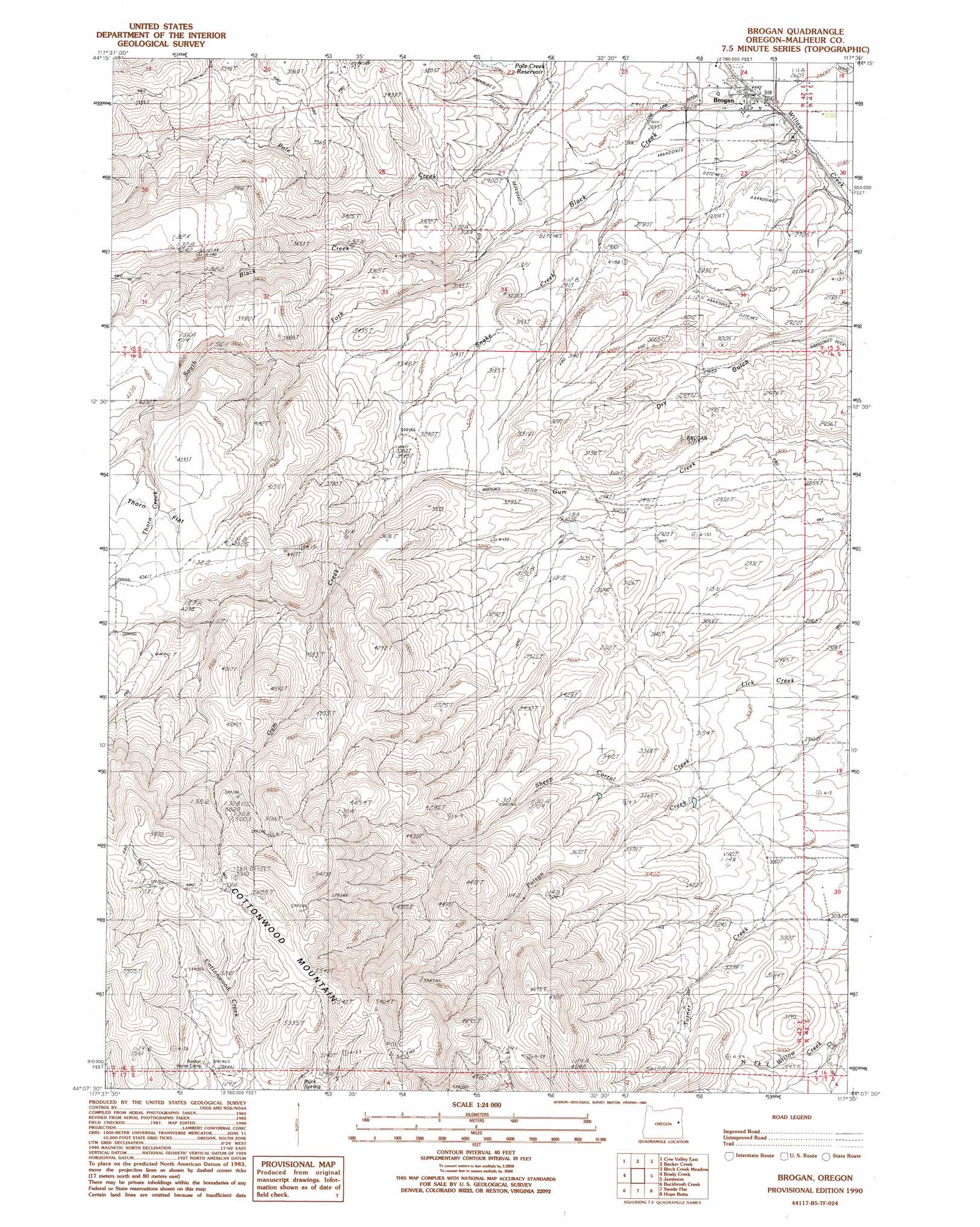
Brogan Topo Map Oregon
To zoom in, hover over the map of Brogan
USGS Topo Quad 44117b5 - 1:24,000 scale
| Topo Map Name: | Brogan |
| USGS Topo Quad ID: | 44117b5 |
| Print Size: | ca. 21 1/4" wide x 27" high |
| Southeast Coordinates: | 44.125° N latitude / 117.5° W longitude |
| Map Center Coordinates: | 44.1875° N latitude / 117.5625° W longitude |
| U.S. State: | OR |
| Filename: | o44117b5.jpg |
| Download Map JPG Image: | Brogan topo map 1:24,000 scale |
| Map Type: | Topographic |
| Topo Series: | 7.5´ |
| Map Scale: | 1:24,000 |
| Source of Map Images: | United States Geological Survey (USGS) |
| Alternate Map Versions: |
Brogan OR 1990, updated 1990 Download PDF Buy paper map Brogan OR 2011 Download PDF Buy paper map Brogan OR 2014 Download PDF Buy paper map |
1:24,000 Topo Quads surrounding Brogan
Wendt Butte |
Bridgeport |
Mormon Basin |
Rye Valley |
Lime |
Cow Valley West |
Cow Valley East |
Becker Creek |
Birch Creek Meadow |
Huntington |
Scratch Post Mountain |
Juniper Mountain |
Brogan |
Jamieson |
Mccarthy Ridge |
Log Creek |
Buckbrush Creek |
Swede Flat |
Hope Butte |
Willow Creek |
Little Black Canyon |
Westfall |
Little Valley |
Vines Hill |
Vale West |
> Back to 44117a1 at 1:100,000 scale
> Back to 44116a1 at 1:250,000 scale
> Back to U.S. Topo Maps home
Brogan topo map: Gazetteer
Brogan: Canals
High Line Ditch elevation 872m 2860′Low Line Ditch elevation 827m 2713′
Brogan: Populated Places
Brogan elevation 797m 2614′Brogan: Post Offices
Brogan Post Office elevation 797m 2614′Brogan: Reservoirs
Lockett Reservoir elevation 1031m 3382′Poison Creek Reservoir elevation 1065m 3494′
Pritchard Reservoir elevation 913m 2995′
Willow Creek Reservoir Four elevation 931m 3054′
Wood Reservoir elevation 992m 3254′
Brogan: Springs
Buck Spring elevation 1512m 4960′Shell Rock Spring elevation 1314m 4311′
Upper Turner Creek Spring elevation 1531m 5022′
Brogan: Streams
Black Creek elevation 793m 2601′Sheep Corral Creek elevation 880m 2887′
Snake Creek elevation 828m 2716′
South Fork Black Creek elevation 886m 2906′
Thorn Creek elevation 1247m 4091′
Brogan: Valleys
Dry Gulch elevation 803m 2634′Brogan digital topo map on disk
Buy this Brogan topo map showing relief, roads, GPS coordinates and other geographical features, as a high-resolution digital map file on DVD: