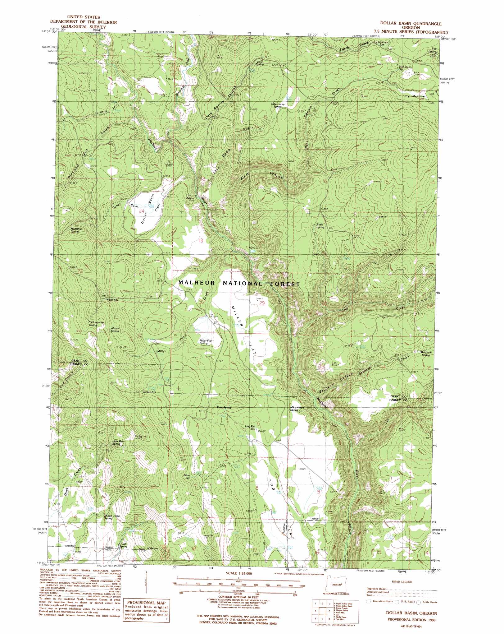
Dollar Basin Topo Map Oregon
To zoom in, hover over the map of Dollar Basin
USGS Topo Quad 44118a5 - 1:24,000 scale
| Topo Map Name: | Dollar Basin |
| USGS Topo Quad ID: | 44118a5 |
| Print Size: | ca. 21 1/4" wide x 27" high |
| Southeast Coordinates: | 44° N latitude / 118.5° W longitude |
| Map Center Coordinates: | 44.0625° N latitude / 118.5625° W longitude |
| U.S. State: | OR |
| Filename: | o44118a5.jpg |
| Download Map JPG Image: | Dollar Basin topo map 1:24,000 scale |
| Map Type: | Topographic |
| Topo Series: | 7.5´ |
| Map Scale: | 1:24,000 |
| Source of Map Images: | United States Geological Survey (USGS) |
| Alternate Map Versions: |
Dollar Basin OR 1988, updated 1988 Download PDF Buy paper map Dollar Basin OR 1996, updated 1998 Download PDF Buy paper map Dollar Basin OR 2011 Download PDF Buy paper map Dollar Basin OR 2014 Download PDF Buy paper map |
| FStopo: | US Forest Service topo Dollar Basin is available: Download FStopo PDF Download FStopo TIF |
1:24,000 Topo Quads surrounding Dollar Basin
Pine Creek Mountain |
Strawberry Mountain |
Roberts Creek |
Little Baldy Mountain |
Bullrun Rock |
Big Canyon |
Logan Valley West |
Logan Valley East |
Crane Prairie |
Flag Prairie |
Jumpoff Joe Mountain |
Magpie Table |
Dollar Basin |
Knox Mountain |
Buck Trough Spring |
Calamity Butte |
Van |
Moffit Table |
Otis Mountain |
Cottonwood Reservoir |
Telephone Butte |
Craft Point |
House Butte |
Drewsey |
Drinkwater Pass |
> Back to 44118a1 at 1:100,000 scale
> Back to 44118a1 at 1:250,000 scale
> Back to U.S. Topo Maps home
Dollar Basin topo map: Gazetteer
Dollar Basin: Basins
Dollar Basin elevation 1522m 4993′Dollar Basin: Flats
Dry Meadow elevation 1770m 5807′Hog Flat elevation 1529m 5016′
Miller Flat elevation 1570m 5150′
Dollar Basin: Springs
Altnow Spring elevation 1771m 5810′Blinn Spring elevation 1689m 5541′
Box Spring elevation 1777m 5830′
Cold Spring elevation 1703m 5587′
Hawk Spring (historical) elevation 1747m 5731′
Hog Flat Spring elevation 1548m 5078′
Jordan Spring elevation 1730m 5675′
Lake Camp Spring elevation 1743m 5718′
Little Bear Spring elevation 1638m 5374′
McAllister Spring elevation 1806m 5925′
McArthur Spring elevation 1769m 5803′
Mike Acton Spring elevation 1540m 5052′
Miller Flat Spring elevation 1585m 5200′
Rock Spring elevation 1537m 5042′
Rock Spring elevation 1729m 5672′
Sheep Corral Spring elevation 1551m 5088′
Skookum Spring elevation 1689m 5541′
Tamarack Spring elevation 1774m 5820′
Twin Spring elevation 1583m 5193′
Wade Spring elevation 1703m 5587′
Yellowjacket Spring elevation 1766m 5793′
Dollar Basin: Streams
Black Canyon Creek elevation 1456m 4776′Cliff Creek elevation 1379m 4524′
Dollar Basin Creek elevation 1476m 4842′
Lee Creek elevation 1338m 4389′
Miller Flat Creek elevation 1462m 4796′
Skookum Creek elevation 1364m 4475′
Summit Creek elevation 1494m 4901′
Tureman Creek elevation 1488m 4881′
Dollar Basin: Valleys
Black Canyon elevation 1459m 4786′Cold Spring Canyon elevation 1479m 4852′
Diamond Dot Gulch elevation 1501m 4924′
Lake Camp Gulch elevation 1459m 4786′
Skookum Canyon elevation 1362m 4468′
Dollar Basin digital topo map on disk
Buy this Dollar Basin topo map showing relief, roads, GPS coordinates and other geographical features, as a high-resolution digital map file on DVD: