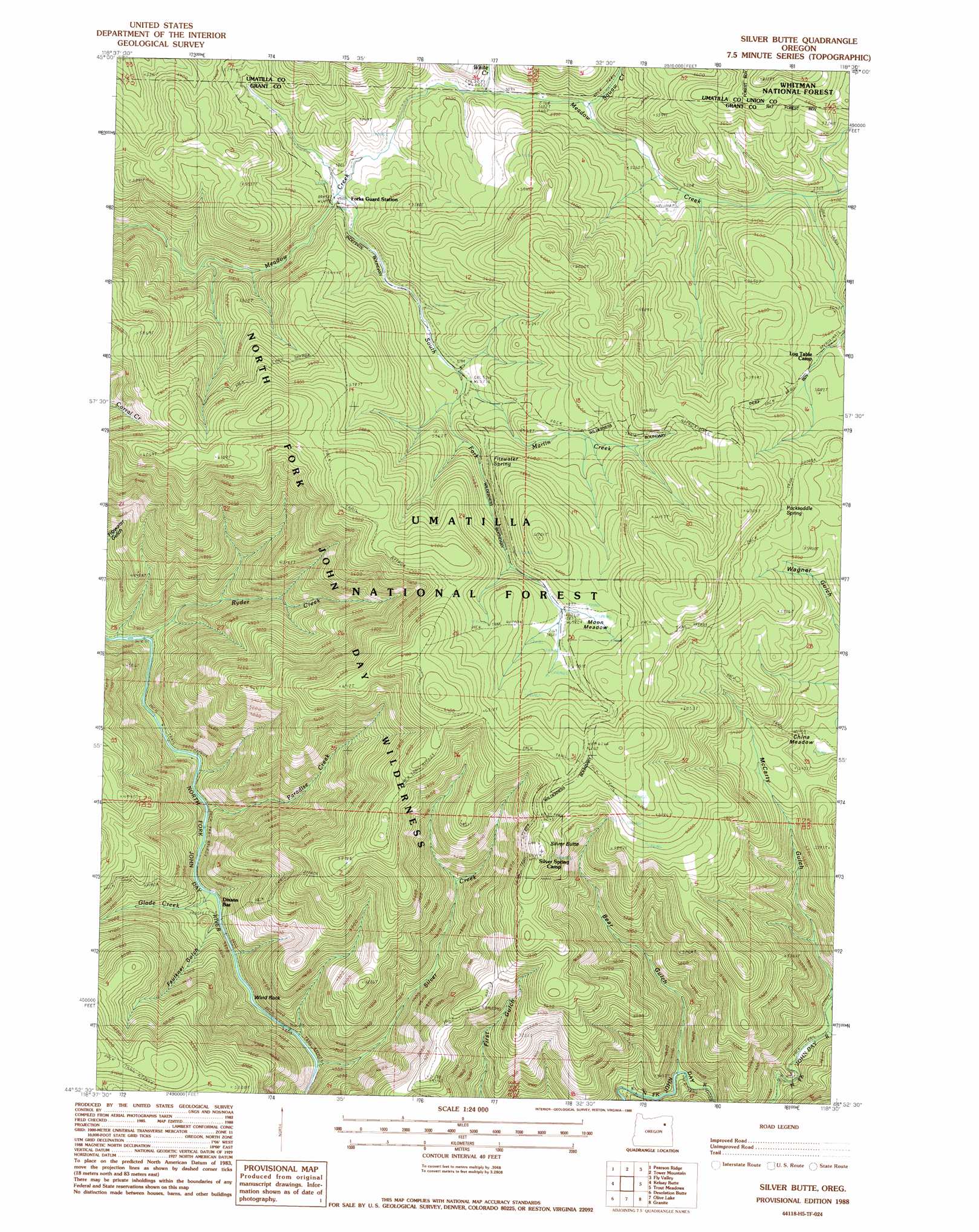
Silver Butte Topo Map Oregon
To zoom in, hover over the map of Silver Butte
USGS Topo Quad 44118h5 - 1:24,000 scale
| Topo Map Name: | Silver Butte |
| USGS Topo Quad ID: | 44118h5 |
| Print Size: | ca. 21 1/4" wide x 27" high |
| Southeast Coordinates: | 44.875° N latitude / 118.5° W longitude |
| Map Center Coordinates: | 44.9375° N latitude / 118.5625° W longitude |
| U.S. State: | OR |
| Filename: | o44118h5.jpg |
| Download Map JPG Image: | Silver Butte topo map 1:24,000 scale |
| Map Type: | Topographic |
| Topo Series: | 7.5´ |
| Map Scale: | 1:24,000 |
| Source of Map Images: | United States Geological Survey (USGS) |
| Alternate Map Versions: |
Silver Butte OR 1988, updated 1988 Download PDF Buy paper map Silver Butte OR 1995, updated 1998 Download PDF Buy paper map Silver Butte OR 2011 Download PDF Buy paper map Silver Butte OR 2014 Download PDF Buy paper map |
| FStopo: | US Forest Service topo Silver Butte is available: Download FStopo PDF Download FStopo TIF |
1:24,000 Topo Quads surrounding Silver Butte
Owens Butte |
Lehman Springs |
Sullivan Gulch |
Marley Creek |
Little Beaver Creek |
Ukiah Se |
Pearson Ridge |
Tower Mountain |
Fly Valley |
Limber Jim Creek |
The Cockscomb |
Kelsay Butte |
Silver Butte |
Trout Meadows |
Crawfish Lake |
Sharp Ridge |
Desolation Butte |
Olive Lake |
Granite |
Mount Ireland |
Susanville |
Boulder Butte |
Vinegar Hill |
Greenhorn |
Whitney |
> Back to 44118e1 at 1:100,000 scale
> Back to 44118a1 at 1:250,000 scale
> Back to U.S. Topo Maps home
Silver Butte topo map: Gazetteer
Silver Butte: Bars
Dixson Bar elevation 1133m 3717′Silver Butte: Flats
China Meadow elevation 1561m 5121′Moon Meadow elevation 1784m 5853′
Silver Butte: Ridges
Wind Rock elevation 1191m 3907′Silver Butte: Springs
Packsaddle Spring elevation 1805m 5921′Silver Butte: Streams
Badger Creek elevation 1797m 5895′Glade Creek elevation 1146m 3759′
Martin Creek elevation 1585m 5200′
Paradise Creek elevation 1140m 3740′
Ryder Creek elevation 1140m 3740′
Silver Creek elevation 1156m 3792′
South Fork Meadow Creek elevation 1521m 4990′
Squaw Creek elevation 1567m 5141′
White Creek elevation 1548m 5078′
Silver Butte: Summits
Silver Butte elevation 1862m 6108′Silver Butte: Trails
Blackwell Trail elevation 1726m 5662′Indian Trail elevation 1831m 6007′
Martin Creek Trail elevation 1837m 6026′
Meadow Creek Driveway Trail elevation 1534m 5032′
Paradise Trail elevation 1815m 5954′
Silver Butte Trail elevation 1732m 5682′
Trout Meadows Trail elevation 1826m 5990′
Wagner Gulch Trail elevation 1594m 5229′
Silver Butte: Valleys
Bear Gulch elevation 1273m 4176′Faulkner Gulch elevation 1135m 3723′
McCarty Gulch elevation 1340m 4396′
Silver Butte digital topo map on disk
Buy this Silver Butte topo map showing relief, roads, GPS coordinates and other geographical features, as a high-resolution digital map file on DVD: