Tower Mountain Topo Map Oregon
To zoom in, hover over the map of Tower Mountain
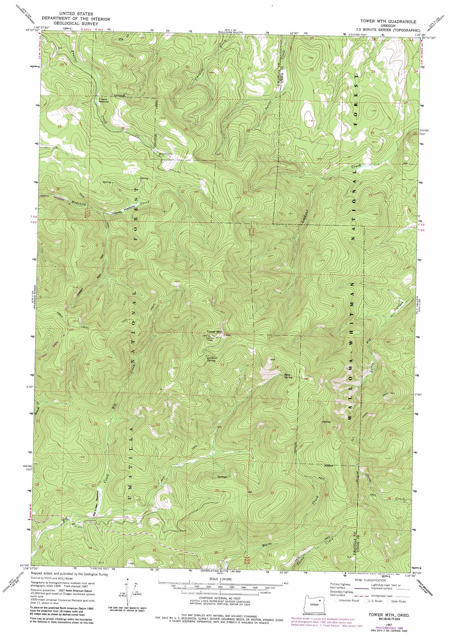
USGS Topo Quad 45118a5 - 1:24,000 scale
| Topo Map Name: | Tower Mountain |
| USGS Topo Quad ID: | 45118a5 |
| Print Size: | ca. 21 1/4" wide x 27" high |
| Southeast Coordinates: | 45° N latitude / 118.5° W longitude |
| Map Center Coordinates: | 45.0625° N latitude / 118.5625° W longitude |
| U.S. State: | OR |
| Filename: | o45118a5.jpg |
| Download Map JPG Image: | Tower Mountain topo map 1:24,000 scale |
| Map Type: | Topographic |
| Topo Series: | 7.5´ |
| Map Scale: | 1:24,000 |
| Source of Map Images: | United States Geological Survey (USGS) |
| Alternate Map Versions: |
Tower Mtn OR 1967, updated 1969 Download PDF Buy paper map Tower Mtn OR 1967, updated 1984 Download PDF Buy paper map Tower Mountain OR 1995, updated 1998 Download PDF Buy paper map Tower Mountain OR 2011 Download PDF Buy paper map Tower Mountain OR 2014 Download PDF Buy paper map |
| FStopo: | US Forest Service topo Tower Mountain is available: Download FStopo PDF Download FStopo TIF |
1:24,000 Topo Quads surrounding Tower Mountain
Granite Meadows |
Tamarack Gulch |
Bally Mountain |
Mcintyre Creek |
Kamela Se |
Owens Butte |
Lehman Springs |
Sullivan Gulch |
Marley Creek |
Little Beaver Creek |
Ukiah Se |
Pearson Ridge |
Tower Mountain |
Fly Valley |
Limber Jim Creek |
The Cockscomb |
Kelsay Butte |
Silver Butte |
Trout Meadows |
Crawfish Lake |
Sharp Ridge |
Desolation Butte |
Olive Lake |
Granite |
Mount Ireland |
> Back to 45118a1 at 1:100,000 scale
> Back to 45118a1 at 1:250,000 scale
> Back to U.S. Topo Maps home
Tower Mountain topo map: Gazetteer
Tower Mountain: Flats
Big Creek Meadow elevation 1561m 5121′Frazier Meadow elevation 1631m 5351′
Hidaway Meadows elevation 1654m 5426′
Tower Mountain: Springs
Lookout Spring elevation 1983m 6505′Reno Spring elevation 1913m 6276′
Tower Mountain: Summits
Tower Mountain elevation 2084m 6837′Tower Mountain: Trails
Fly Creek Trail elevation 1787m 5862′Tower Mountain digital topo map on disk
Buy this Tower Mountain topo map showing relief, roads, GPS coordinates and other geographical features, as a high-resolution digital map file on DVD: